TopoQuest Logo
Do you find TopoQuest useful?
Help keep TopoQuest running and adding new maps/features by donating!
Bitcoin:  19c7KJd3qBynnjoSw5npx9KScwjBe4ifkT
Litecoin:  LXs6TkuXGGXo1vDsWCkWVdjQX94eUKd6ui
Home View Maps Find Maps Find Places Resources & Links


Said Valley, California Topographic Map

USGS Map Title: Said Valley, CA
USGS Map MRC: 40120H7
DRG (GeoTIFF) Download: o40120h7.tif


Neighboring USGS Topographic Map Quads:


  Letterbox Hill, CA  
41120A8
 

  Lane Reservoir, CA  
41120A7
 

  Ash Valley, CA  
41120A6
 

  Silva Flat Reservoir, CA  
40120H8
 

  Said Valley, CA  
40120H7
 

  Whitinger Mountain, CA  
40120H6
 

  Bullard Lake, CA  
40120G8
 

  Sheepshead, CA  
40120G7
 

  Grasshopper Valley, CA  
40120G6


Map MRC Location:

N41°
W121°
N41°
W120°
H8 H7 H6 H5 H4 H3 H2 H1
G8 G7 G6 G5 G4 G3 G2 G1
F8 F7 F6 F5 F4 F3 F2 F1
E8 E7 E6 E5 E4 E3 E2 E1
D8 D7 D6 D5 D4 D3 D2 D1
C8 C7 C6 C5 C4 C3 C2 C1
B8 B7 B6 B5 B4 B3 B2 B1
A8 A7 A6 A5 A4 A3 A2 A1
N40°
W121°
N40°
W120°

Said Valley, CA USGS 1:24K Topographic Map Preview:
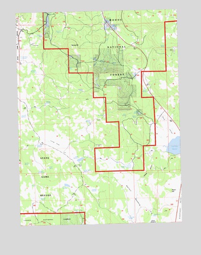
Said Valley, CA USGS Topographic Map
Click on map above to begin viewing in our Map Viewer.

This topographic map contains these locations and features:
Feature Name Type Latitude Longitude GNIS ID View Map
Abbott ReservoirReservoirN40.9061°W120.8607°1665823View Map
Abbott SpringSpringN40.9088°W120.8530°217941View Map
Acre Foot ReservoirReservoirN40.8904°W120.8605°1665824View Map
Ambrose ReservoirReservoirN40.9342°W120.8206°218221View Map
Boffengers ReservoirReservoirN40.8947°W120.8205°1665836View Map
Bosco HillSummitN40.8932°W120.7597°1665837View Map
Box SpringSpringN40.9384°W120.8091°219735View Map
Catfish ReservoirReservoirN40.9132°W120.8278°220726View Map
Chicken SpringSpringN40.9784°W120.7610°220978View Map
Clay Flat ReservoirReservoirN40.9402°W120.8700°1665848View Map
Coon Camp SpringSpringN40.8784°W120.7925°221497View Map
Dago SpringSpringN40.9657°W120.8364°275050View Map
Daisy Dean SpringSpringN40.9861°W120.8554°221981View Map
Drift Fence ReservoirReservoirN40.9738°W120.8725°1665859View Map
Four Pine SpringSpringN40.9530°W120.8253°223746View Map
Hatfield ReservoirReservoirN40.9462°W120.8547°225017View Map
Hayden HillSummitN40.9985°W120.8702°225048View Map
Hazelton ReservoirReservoirN40.9646°W120.8612°225090View Map
Hencratt CampLocaleN40.9221°W120.8158°225161View Map
Horse MeadowAreaN40.8752°W120.7738°1665868View Map
Horse Meadow SpringSpringN40.8792°W120.7742°1665870View Map
Indian SpringSpringN40.9987°W120.8504°225906View Map
Italian SpringSpringN40.9669°W120.8361°1664814View Map
Johnson CampLocaleN40.9118°W120.8300°226295View Map
Juniper SpringSpringN40.9057°W120.8263°226401View Map
Juniper Spring ReservoirReservoirN40.9055°W120.8263°1665877View Map
Long FlatFlatN40.9241°W120.8450°227556View Map
Long Flat ReservoirReservoirN40.9226°W120.8594°1665884View Map
Long ReservoirReservoirN40.8980°W120.8393°227598View Map
Mapes LakeLakeN40.9084°W120.7914°1665888View Map
Rock SpringSpringN40.9379°W120.7924°1665899View Map
Said ValleyValleyN40.9232°W120.7563°232118View Map
Said Valley ReservoirReservoirN40.9196°W120.7547°232119View Map
Six Mile SpringSpringN40.9110°W120.8719°1665906View Map
Spring HillSummitN40.9796°W120.8322°235265View Map
Spring Hill ReservoirReservoirN40.9886°W120.8404°1665909View Map
Spring Hill SpringSpringN40.9712°W120.8145°235268View Map
Stratton ReservoirReservoirN40.9389°W120.7819°1665912View Map
Stratton SpringSpringN40.9372°W120.7842°235577View Map
Totten CampLocaleN40.9766°W120.7550°236471View Map
Upper McBride SpringSpringN40.9911°W120.8017°236902View Map
Walton MeadowAreaN40.8893°W120.7872°1665922View Map
West Fork Willow CreekStreamN40.9943°W120.8069°237489View Map
Wildcat CanyonValleyN40.9188°W120.7691°1665925View Map
Willow SpringSpringN40.8828°W120.8300°237942View Map
Wing ReservoirReservoirN40.9538°W120.7773°238041View Map

Note: Coordinates in the location and feature list above are referenced to NAD83 datum.


Copyright (C) 2008-2025 Ryan Niemi / Sunset Dynamics ... All Rights Reserved