TopoQuest Logo
Do you find TopoQuest useful?
Help keep TopoQuest running and adding new maps/features by donating!
Bitcoin:  19c7KJd3qBynnjoSw5npx9KScwjBe4ifkT
Litecoin:  LXs6TkuXGGXo1vDsWCkWVdjQX94eUKd6ui
Home View Maps Find Maps Find Places Resources & Links


Lavonia, Georgia Topographic Map

USGS Map Title: Lavonia, GA
USGS Map MRC: 34083D1
DRG (GeoTIFF) Download: o34083d1.tif


Neighboring USGS Topographic Map Quads:


  Avalon, GA  
34083E2
 

  Oakway, SC  
34083E1
 

  Fair Play, SC  
34082E8
 

  Martin, GA  
34083D2
 

  Lavonia, GA  
34083D1
 

  Reed Creek, GA  
34082D8
 

  Carnesville, GA  
34083C2
 

  Royston, GA  
34083C1
 

  Hartwell, GA  
34082C8


Map MRC Location:

N35°
W84°
N35°
W83°
H8 H7 H6 H5 H4 H3 H2 H1
G8 G7 G6 G5 G4 G3 G2 G1
F8 F7 F6 F5 F4 F3 F2 F1
E8 E7 E6 E5 E4 E3 E2 E1
D8 D7 D6 D5 D4 D3 D2 D1
C8 C7 C6 C5 C4 C3 C2 C1
B8 B7 B6 B5 B4 B3 B2 B1
A8 A7 A6 A5 A4 A3 A2 A1
N34°
W84°
N34°
W83°

Lavonia, GA USGS 1:24K Topographic Map Preview:
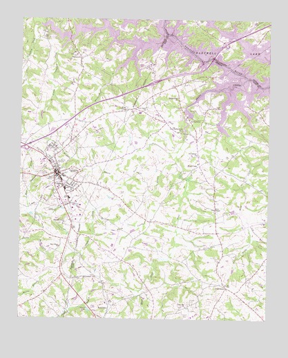
Lavonia, GA USGS Topographic Map
Click on map above to begin viewing in our Map Viewer.

This topographic map contains these locations and features:
Feature Name Type Latitude Longitude GNIS ID View Map
Bowersville City CemeteryCemeteryN34.3820°W83.0799°335609View Map
Bowersville DivisionCivilN34.4095°W83.0466°1936124View Map
Caney BranchStreamN34.4409°W83.0454°312298View Map
City of LavoniaCivilN34.4344°W83.1082°2404894View Map
Cleveland Ferry (historical)CrossingN34.4807°W83.0207°1242948View Map
Cleveland Ferry (historical)CrossingN34.4807°W83.0207°335617View Map
Crawford CreekStreamN34.4970°W83.1160°313094View Map
Cross RoadsPopulated PlaceN34.3882°W83.0201°355384View Map
Cross Roads Baptist ChurchChurchN34.3895°W83.0204°335623View Map
Crossroads CemeteryCemeteryN34.3898°W83.0213°335624View Map
Deans LakeReservoirN34.3789°W83.0901°313398View Map
Exit 58CrossingN34.4462°W83.1243°1705001View Map
Exit 59CrossingN34.4737°W83.0582°1705019View Map
First Baptist ChurchChurchN34.4373°W83.1052°349323View Map
Fred E Lee MemorialParkN34.4751°W83.0338°335634View Map
Gum Log CreekStreamN34.4982°W83.1154°328020View Map
GumlogPopulated PlaceN34.4918°W83.0965°1867242View Map
Gumlog Census Designated PlaceCensusN34.4952°W83.0975°2402557View Map
Hart County Fire Department Station 4 Shoal CreekBuildingN34.4400°W83.0353°2604439View Map
Interchange 1CrossingN34.4901°W83.0221°1228259View Map
Jones Street Residential Historic DistrictParkN34.4382°W83.1085°349333View Map
Kesse CemeteryCemeteryN34.4995°W83.0340°1223722View Map
Knox Bridge (historical)BridgeN34.4807°W83.0207°335660View Map
Knox Bridge (historical)BridgeN34.4807°W83.0207°1243038View Map
LavoniaPopulated PlaceN34.4359°W83.1068°316687View Map
Lavonia Carnegie LibraryBuildingN34.4348°W83.1038°349334View Map
Lavonia Commercial Historic DistrictParkN34.4362°W83.1065°349335View Map
Lavonia Elementary SchoolSchoolN34.4307°W83.0913°349336View Map
Lavonia Fire DepartmentBuildingN34.4283°W83.1068°2603899View Map
Lavonia High SchoolSchoolN34.4343°W83.1029°349337View Map
Lavonia Police DepartmentBuildingN34.4348°W83.1071°2733959View Map
Little Crawford CreekStreamN34.4873°W83.1052°317001View Map
Little Shoal CreekStreamN34.4515°W83.0207°317198View Map
Maret CemeteryCemeteryN34.4629°W83.0251°317686View Map
New Hope ChurchChurchN34.4051°W83.1046°319440View Map
New Light CemeteryCemeteryN34.4634°W83.0610°335679View Map
New Light ChurchChurchN34.4640°W83.0618°319470View Map
Old Salem Methodist Church (historical)ChurchN34.3812°W83.0799°335684View Map
ParkertownPopulated PlaceN34.4576°W83.0399°332611View Map
Parkertown MillPopulated PlaceN34.4540°W83.0432°332612View Map
Pleasant Grove ChurchChurchN34.4143°W83.1032°320845View Map
Poole CemeteryCemeteryN34.4270°W83.0738°321006View Map
Pooles CreekStreamN34.4454°W83.0454°321008View Map
Price ChapelChurchN34.4209°W83.0268°321135View Map
Price Chapel CemeteryCemeteryN34.4209°W83.0271°335689View Map
Providence CemeteryCemeteryN34.4434°W83.0351°335690View Map
Providence ChurchChurchN34.4434°W83.0360°321206View Map
Shoal CreekPopulated PlaceN34.4395°W83.0346°333040View Map
Shoal CreekStreamN34.4715°W83.0271°322937View Map
Shoal Creek CemeteryCemeteryN34.4676°W83.0451°335708View Map
Shoal Creek ChurchChurchN34.4673°W83.0457°322945View Map
Shoal Creek School (historical)SchoolN34.4398°W83.0354°335709View Map
Shuford Municipal Airport (historical)AirportN34.4209°W83.1088°349353View Map
Taylor MineMineN34.3848°W83.0407°347478View Map
Tugaloo State ParkParkN34.4948°W83.0679°349356View Map
Union Hill CemeteryCemeteryN34.3801°W83.0407°335713View Map
Union Hill ChurchChurchN34.3801°W83.0404°324574View Map
Viola School (historical)SchoolN34.4109°W83.0618°335715View Map
West Avenue-Roberts Street Residential Historic DistrictParkN34.4343°W83.1088°349358View Map
WhitworthPopulated PlaceN34.4840°W83.0949°326591View Map
Whitworth CreekStreamN34.4776°W83.0777°325243View Map
Williams CemeteryCemeteryN34.3895°W83.0824°335717View Map
Willis ChapelChurchN34.4623°W83.0715°325393View Map
Wrights BranchStreamN34.4479°W83.0563°325576View Map

Note: Coordinates in the location and feature list above are referenced to NAD83 datum.


Copyright (C) 2008-2025 Ryan Niemi / Sunset Dynamics ... All Rights Reserved