TopoQuest Logo
Do you find TopoQuest useful?
Help keep TopoQuest running and adding new maps/features by donating!
Bitcoin:  19c7KJd3qBynnjoSw5npx9KScwjBe4ifkT
Litecoin:  LXs6TkuXGGXo1vDsWCkWVdjQX94eUKd6ui
Home View Maps Find Maps Find Places Resources & Links


Carnesville, Georgia Topographic Map

USGS Map Title: Carnesville, GA
USGS Map MRC: 34083C2
DRG (GeoTIFF) Download: o34083c2.tif


Neighboring USGS Topographic Map Quads:


  Red Hill, GA  
34083D3
 

  Martin, GA  
34083D2
 

  Lavonia, GA  
34083D1
 

  Ashland, GA  
34083C3
 

  Carnesville, GA  
34083C2
 

  Royston, GA  
34083C1
 

  Ila, GA  
34083B3
 

  Danielsville North, GA  
34083B2
 

  Bowman, GA  
34083B1


Map MRC Location:

N35°
W84°
N35°
W83°
H8 H7 H6 H5 H4 H3 H2 H1
G8 G7 G6 G5 G4 G3 G2 G1
F8 F7 F6 F5 F4 F3 F2 F1
E8 E7 E6 E5 E4 E3 E2 E1
D8 D7 D6 D5 D4 D3 D2 D1
C8 C7 C6 C5 C4 C3 C2 C1
B8 B7 B6 B5 B4 B3 B2 B1
A8 A7 A6 A5 A4 A3 A2 A1
N34°
W84°
N34°
W83°

Carnesville, GA USGS 1:24K Topographic Map Preview:
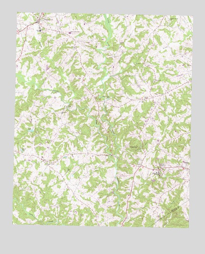
Carnesville, GA USGS Topographic Map
Click on map above to begin viewing in our Map Viewer.

This topographic map contains these locations and features:
Feature Name Type Latitude Longitude GNIS ID View Map
Atkinson BridgeBridgeN34.3198°W83.2127°310656View Map
Brays LakeReservoirN34.3054°W83.2377°311740View Map
Brays Lake DamDamN34.3059°W83.2360°339206View Map
Brooks LakeReservoirN34.2936°W83.2440°311833View Map
CarnesvillePopulated PlaceN34.3698°W83.2352°312348View Map
Carnesville Elementary SchoolSchoolN34.3644°W83.2332°349312View Map
Carnesville Volunteer Fire DepartmentBuildingN34.3683°W83.2401°2603683View Map
Carrolls ChurchChurchN34.3579°W83.1763°355002View Map
Center CemeteryCemeteryN34.2868°W83.1593°312509View Map
City of CarnesvilleCivilN34.3720°W83.2344°2403997View Map
City of Franklin SpringsCivilN34.2840°W83.1459°2403661View Map
Cross Roads ChurchChurchN34.3640°W83.2477°349316View Map
Crow CemeteryCemeteryN34.3179°W83.2160°313183View Map
Double BranchStreamN34.3409°W83.1754°355519View Map
Double Branch ChurchChurchN34.3723°W83.1410°313566View Map
Duncans Mill (historical)LocaleN34.3468°W83.1590°349318View Map
Emmanuel CollegeSchoolN34.2822°W83.1472°313941View Map
Faith Fellowship ChurchChurchN34.3601°W83.2096°349322View Map
Five Area Fire DepartmentBuildingN34.3665°W83.1524°2604229View Map
Franklin County AirportAirportN34.3414°W83.1313°351703View Map
Franklin County CourthouseBuildingN34.3698°W83.2346°349325View Map
Franklin County High SchoolSchoolN34.3635°W83.2121°349326View Map
Franklin County JailBuildingN34.3692°W83.2421°2734116View Map
Franklin County Sheriff's DepartmentBuildingN34.3691°W83.2420°2733514View Map
Franklin Memorial GardensCemeteryN34.2757°W83.1304°349328View Map
Franklin SpringsPopulated PlaceN34.2848°W83.1443°331767View Map
Franklin Springs Police DepartmentBuildingN34.2857°W83.1591°2733815View Map
Franklin Springs Volunteer Fire DepartmentBuildingN34.2840°W83.1521°2603691View Map
Gaines ChapelChurchN34.3251°W83.1574°314474View Map
Gary Memorial GardensCemeteryN34.2909°W83.2160°349329View Map
James CemeteryCemeteryN34.2612°W83.2190°316036View Map
Latner CemeteryCemeteryN34.3451°W83.1568°316662View Map
Liberty ChurchChurchN34.3545°W83.2074°316822View Map
Liberty Lookout TowerTowerN34.3640°W83.2118°344271View Map
Middle Fork Broad RiverStreamN34.2879°W83.1771°356387View Map
North Fork Broad RiverStreamN34.2876°W83.1771°329045View Map
Pennington ChapelChurchN34.2873°W83.2240°349341View Map
Poplar Springs CampgroundsLocaleN34.3362°W83.1513°321035View Map
R M Star MemorialParkN34.3204°W83.1765°349344View Map
Rice CreekStreamN34.2959°W83.1765°321558View Map
Riverside ChurchChurchN34.3162°W83.2171°321652View Map
Royston DivisionCivilN34.3192°W83.1435°1936515View Map
Sandy CrossPopulated PlaceN34.2873°W83.2260°326504View Map
Sandy Cross ChurchChurchN34.2879°W83.2290°349351View Map
Sandy Cross Volunteer Fire DepartmentBuildingN34.2891°W83.2294°2604351View Map
Starr Bridge LakeReservoirN34.3254°W83.1834°323532View Map
Stephens CreekStreamN34.3220°W83.2110°323575View Map
Unawatti CreekStreamN34.3365°W83.1871°356606View Map
Victoria Bryant State ParkParkN34.2965°W83.1599°324696View Map
Zidon (historical)Populated PlaceN34.3059°W83.2360°349359View Map
Zidon CemeteryCemeteryN34.2818°W83.2113°1705002View Map
Zidon ChurchChurchN34.2823°W83.2115°325667View Map

Note: Coordinates in the location and feature list above are referenced to NAD83 datum.


Copyright (C) 2008-2025 Ryan Niemi / Sunset Dynamics ... All Rights Reserved