TopoQuest Logo
Do you find TopoQuest useful?
Help keep TopoQuest running and adding new maps/features by donating!
Bitcoin:  19c7KJd3qBynnjoSw5npx9KScwjBe4ifkT
Litecoin:  LXs6TkuXGGXo1vDsWCkWVdjQX94eUKd6ui
Home View Maps Find Maps Find Places Resources & Links


Royston, Georgia Topographic Map

USGS Map Title: Royston, GA
USGS Map MRC: 34083C1
DRG (GeoTIFF) Download: o34083c1.tif


Neighboring USGS Topographic Map Quads:


  Martin, GA  
34083D2
 

  Lavonia, GA  
34083D1
 

  Reed Creek, GA  
34082D8
 

  Carnesville, GA  
34083C2
 

  Royston, GA  
34083C1
 

  Hartwell, GA  
34082C8
 

  Danielsville North, GA  
34083B2
 

  Bowman, GA  
34083B1
 

  Dewy Rose, GA  
34082B8


Map MRC Location:

N35°
W84°
N35°
W83°
H8 H7 H6 H5 H4 H3 H2 H1
G8 G7 G6 G5 G4 G3 G2 G1
F8 F7 F6 F5 F4 F3 F2 F1
E8 E7 E6 E5 E4 E3 E2 E1
D8 D7 D6 D5 D4 D3 D2 D1
C8 C7 C6 C5 C4 C3 C2 C1
B8 B7 B6 B5 B4 B3 B2 B1
A8 A7 A6 A5 A4 A3 A2 A1
N34°
W84°
N34°
W83°

Royston, GA USGS 1:24K Topographic Map Preview:
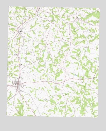
Royston, GA USGS Topographic Map
Click on map above to begin viewing in our Map Viewer.

This topographic map contains these locations and features:
Feature Name Type Latitude Longitude GNIS ID View Map
Air LineLocaleN34.3626°W83.0304°354267View Map
Air Line Elementary SchoolSchoolN34.3643°W83.0301°335599View Map
Allen CemeteryCemeteryN34.3157°W83.1090°310447View Map
Bakers BridgeBridgeN34.2737°W83.0629°310747View Map
Beaverdam Creek Structure Number 21 DamDamN34.2651°W83.0165°336466View Map
Beaverdam Creek Structure Number Six DamDamN34.2851°W83.0799°336456View Map
Beaverdam Creek Watershed Structure Number 17 DamDamN34.2984°W83.0132°336464View Map
Beaverdam Creek Watershed Structure Number Eight DamDamN34.3184°W83.0532°336460View Map
Berryman CemeteryCemeteryN34.2645°W83.1157°311120View Map
Bethany CemeteryCemeteryN34.3304°W83.0149°335604View Map
Bethany ChurchChurchN34.3301°W83.0149°354582View Map
Bowers CemeteryCemeteryN34.3490°W83.0871°311677View Map
BowersvillePopulated PlaceN34.3729°W83.0826°331215View Map
Bowersville Historic DistrictParkN34.3720°W83.0838°335610View Map
Brooks LakeReservoirN34.2979°W83.0315°311834View Map
Brooks Lake DamDamN34.2968°W83.0301°339491View Map
Brown Health Rehabilitation HospitalHospitalN34.2832°W83.1191°2611014View Map
Brown Hospital (historical)HospitalN34.2873°W83.1124°349310View Map
Browns Grove CemeteryCemeteryN34.2882°W83.0549°335612View Map
CanonPopulated PlaceN34.3462°W83.1099°354984View Map
Canon Commercial Historic DistrictParkN34.3462°W83.1101°349311View Map
Canon Police DepartmentBuildingN34.3440°W83.1094°2733914View Map
Canon Volunteer Fire DepartmentBuildingN34.3479°W83.1085°2603630View Map
Church of GodChurchN34.2807°W83.1113°349313View Map
City of CanonCivilN34.3455°W83.1107°2403986View Map
City of RoystonCivilN34.2859°W83.1097°2404653View Map
Clarks CreekStreamN34.2740°W83.0165°312693View Map
Cobb Memorial HospitalHospitalN34.2844°W83.1186°349314View Map
Duncan School (historical)SchoolN34.3320°W83.0707°335626View Map
Eagle GrovePopulated PlaceN34.2962°W83.0068°326255View Map
Eagle Grove Census Designated PlaceCensusN34.2918°W83.0043°2587033View Map
Eagle Grove Elementary SchoolSchoolN34.2943°W83.0065°335627View Map
Fowler CemeteryCemeteryN34.3301°W83.1046°314327View Map
GoldminePopulated PlaceN34.2907°W83.0460°331836View Map
Goldmine ChurchChurchN34.2757°W83.0451°314676View Map
Goldmine ChurchChurchN34.2929°W83.0243°314677View Map
Goldmine School (historical)SchoolN34.2929°W83.0454°335637View Map
Grace ChurchChurchN34.2937°W83.0860°335638View Map
Gunnels DamDamN34.3101°W83.0415°338754View Map
Gunnels LakeReservoirN34.3101°W83.0415°338755View Map
Harmony Grove CemeteryCemeteryN34.3229°W83.0943°335639View Map
Harmony Grove ChurchChurchN34.3220°W83.0932°356193View Map
Hart County Fire Department Station 3 GoldmineBuildingN34.2909°W83.0467°2604440View Map
Hart County Fire Department Station 5 BowersvilleBuildingN34.3621°W83.0736°2604441View Map
Hendrys Baptist Church (historical)ChurchN34.2901°W83.0210°335657View Map
Henrys Church MonumentParkN34.2901°W83.0210°335658View Map
Historic Churches of Canon Historic DistrictParkN34.3451°W83.1099°349331View Map
Holiness Church (historical)ChurchN34.2887°W83.1096°349332View Map
Macedonia CemeteryCemeteryN34.3395°W83.0382°335664View Map
Macedonia ChurchChurchN34.3395°W83.0385°317574View Map
Manly CemeteryCemeteryN34.3468°W83.0946°335665View Map
North Broad River Structure Number 28 DamDamN34.3701°W83.1165°336622View Map
North Hart Elementary SchoolSchoolN34.3749°W83.0021°2545558View Map
Oak View CemeteryCemeteryN34.3509°W83.1101°319852View Map
Old Canon CemeteryCemeteryN34.3584°W83.0632°335682View Map
Old Canon ChurchChurchN34.3590°W83.0632°319953View Map
Old Hendry CemeteryCemeteryN34.2895°W83.0199°319988View Map
Old Macedonia CemeteryCemeteryN34.3470°W83.0104°319995View Map
Pruitt CreekStreamN34.2748°W83.0640°321210View Map
Redwine CemeteryCemeteryN34.3090°W83.0585°335691View Map
Redwine ChurchChurchN34.3093°W83.0579°321427View Map
Reservoir 17ReservoirN34.3023°W83.0132°336465View Map
Reservoir 21ReservoirN34.2656°W83.0181°336467View Map
Reservoir 28ReservoirN34.3701°W83.1165°336623View Map
Reservoir EightReservoirN34.3215°W83.0537°336461View Map
Reservoir SixReservoirN34.2851°W83.0799°336457View Map
Rice Creek ChurchChurchN34.3190°W83.1110°321559View Map
Ridgeway Hospital (historical)HospitalN34.2843°W83.1110°349346View Map
Rose Hill CemeteryCemeteryN34.2776°W83.1065°321916View Map
Roy CemeteryCemeteryN34.2648°W83.0540°321978View Map
RoystonPopulated PlaceN34.2871°W83.1101°321981View Map
Royston Baptist ChurchChurchN34.2837°W83.1110°349347View Map
Royston City JailBuildingN34.2847°W83.1102°2734088View Map
Royston Commercial Historic DistrictParkN34.2862°W83.1101°349348View Map
Royston DivisionCivilN34.2795°W83.0596°1936516View Map
Royston Elementary SchoolSchoolN34.2891°W83.1140°349349View Map
Royston Fire DepartmentBuildingN34.2858°W83.1090°2603910View Map
Royston Police DepartmentBuildingN34.2847°W83.1101°2733942View Map
Starr CemeteryCemeteryN34.3068°W83.1021°323533View Map
Town of BowersvilleCivilN34.3727°W83.0831°2405306View Map
WBIC-AM (Royston)TowerN34.2807°W83.1190°352537View Map
White CemeteryCemeteryN34.3129°W83.0035°325147View Map
Wilders PondReservoirN34.2696°W83.0721°325288View Map
WPUP-FM (Royston)TowerN34.2807°W83.1190°352766View Map

Note: Coordinates in the location and feature list above are referenced to NAD83 datum.


Copyright (C) 2008-2024 Ryan Niemi / Sunset Dynamics ... All Rights Reserved