TopoQuest Logo
Do you find TopoQuest useful?
Help keep TopoQuest running and adding new maps/features by donating!
Bitcoin:  19c7KJd3qBynnjoSw5npx9KScwjBe4ifkT
Litecoin:  LXs6TkuXGGXo1vDsWCkWVdjQX94eUKd6ui
Home View Maps Find Maps Find Places Resources & Links


Lawrence Arroyo, New Mexico Topographic Map

USGS Map Title: Lawrence Arroyo, NM
USGS Map MRC: 36104D1
DRG (GeoTIFF) Download: o36104d1.tif


Neighboring USGS Topographic Map Quads:


  Pine Buttes, NM  
36104E2
 

  Palo Blanco Mountain, NM  
36104E1
 

  Malpie Mountain, NM  
36103E8
 

  Point of Rocks Mesa, NM  
36104D2
 

  Lawrence Arroyo, NM  
36104D1
 

  Gladstone NW, NM  
36103D8
 

  Ingram Lake, NM  
36104C2
 

  Farley, NM  
36104C1
 

  Gladstone, NM  
36103C8


Map MRC Location:

N37°
W105°
N37°
W104°
H8 H7 H6 H5 H4 H3 H2 H1
G8 G7 G6 G5 G4 G3 G2 G1
F8 F7 F6 F5 F4 F3 F2 F1
E8 E7 E6 E5 E4 E3 E2 E1
D8 D7 D6 D5 D4 D3 D2 D1
C8 C7 C6 C5 C4 C3 C2 C1
B8 B7 B6 B5 B4 B3 B2 B1
A8 A7 A6 A5 A4 A3 A2 A1
N36°
W105°
N36°
W104°

Lawrence Arroyo, NM USGS 1:24K Topographic Map Preview:
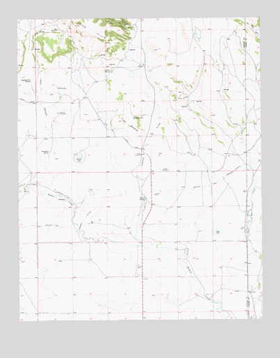
Lawrence Arroyo, NM USGS Topographic Map
Click on map above to begin viewing in our Map Viewer.

This topographic map contains these locations and features:
Feature Name Type Latitude Longitude GNIS ID View Map
Archuleta WindmillLocaleN36.4586°W104.0622°885875View Map
Barela SpringsSpringN36.4245°W104.0603°886064View Map
Cart CanyonValleyN36.4292°W104.1069°887231View Map
Cleto LakeLakeN36.4112°W104.0231°887683View Map
Coffee WindmillLocaleN36.4370°W104.0508°887728View Map
Dipping Vat SpringSpringN36.4742°W104.1186°888396View Map
Horseshoe SpringSpringN36.4448°W104.1097°890195View Map
Laird CanyonValleyN36.4961°W104.0636°890872View Map
Las MesetasSummitN36.4575°W104.0716°890956View Map
Lawrence ArroyoStreamN36.4048°W104.0541°890993View Map
Mesa WindmillLocaleN36.4956°W104.1041°891884View Map
Ojo de LlanoSpringN36.4714°W104.1047°898087View Map
Reville WindmillLocaleN36.4611°W104.1033°893873View Map
RomeroLocaleN36.4650°W104.0964°928385View Map
Rufelio SpringSpringN36.4781°W104.0766°894212View Map
Stevens LakeLakeN36.4420°W104.0922°895338View Map
Tafoya (historical)Populated PlaceN36.4459°W104.0614°933146View Map
Tafoya Post Office (historical)Post OfficeN36.4459°W104.0614°937832View Map
Tafoya WindmillLocaleN36.4436°W104.0614°895489View Map
Torcido CanyonValleyN36.4967°W104.0689°895762View Map

Note: Coordinates in the location and feature list above are referenced to NAD83 datum.


Copyright (C) 2008-2025 Ryan Niemi / Sunset Dynamics ... All Rights Reserved