TopoQuest Logo
Do you find TopoQuest useful?
Help keep TopoQuest running and adding new maps/features by donating!
Bitcoin:  19c7KJd3qBynnjoSw5npx9KScwjBe4ifkT
Litecoin:  LXs6TkuXGGXo1vDsWCkWVdjQX94eUKd6ui
Home View Maps Find Maps Find Places Resources & Links


Point of Rocks Mesa, New Mexico Topographic Map

USGS Map Title: Point of Rocks Mesa, NM
USGS Map MRC: 36104D2
DRG (GeoTIFF) Download: o36104d2.tif


Neighboring USGS Topographic Map Quads:


  Tres Hermanos Peak, NM  
36104E3
 

  Pine Buttes, NM  
36104E2
 

  Palo Blanco Mountain, NM  
36104E1
 

  Sauble Circle Dot Ranch, NM  
36104D3
 

  Point of Rocks Mesa, NM  
36104D2
 

  Lawrence Arroyo, NM  
36104D1
 

  Abbott, NM  
36104C3
 

  Ingram Lake, NM  
36104C2
 

  Farley, NM  
36104C1


Map MRC Location:

N37°
W105°
N37°
W104°
H8 H7 H6 H5 H4 H3 H2 H1
G8 G7 G6 G5 G4 G3 G2 G1
F8 F7 F6 F5 F4 F3 F2 F1
E8 E7 E6 E5 E4 E3 E2 E1
D8 D7 D6 D5 D4 D3 D2 D1
C8 C7 C6 C5 C4 C3 C2 C1
B8 B7 B6 B5 B4 B3 B2 B1
A8 A7 A6 A5 A4 A3 A2 A1
N36°
W105°
N36°
W104°

Point of Rocks Mesa, NM USGS 1:24K Topographic Map Preview:
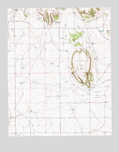
Point of Rocks Mesa, NM USGS Topographic Map
Click on map above to begin viewing in our Map Viewer.

This topographic map contains these locations and features:
Feature Name Type Latitude Longitude GNIS ID View Map
Black HillSummitN36.3992°W104.2233°899531View Map
Blackjack CanyonValleyN36.4348°W104.1730°886466View Map
ChicoPopulated PlaceN36.4867°W104.1928°902210View Map
Chico Post Office (historical)Post OfficeN36.4867°W104.1928°937982View Map
Chico SpringsSpringN36.4983°W104.2396°887510View Map
Colfax County Fire Department District 4 Farley SubstationBuildingN36.3998°W104.1521°2658217View Map
Coulter WellWellN36.4139°W104.1880°887957View Map
Dorsey Mansion State MonumentParkN36.4853°W104.1936°888469View Map
Goldmine CanyonValleyN36.4250°W104.1505°889475View Map
Halliwell WellLocaleN36.4578°W104.1778°889730View Map
HinstonLocaleN36.3959°W104.2125°924746View Map
Hogback ButteSummitN36.4350°W104.1544°890052View Map
Hollenbeck CemeteryCemeteryN36.4700°W104.1825°890075View Map
Joe Cabin ArroyoStreamN36.4267°W104.1303°890469View Map
Jones WellWellN36.4248°W104.1705°890561View Map
McBride WellWellN36.4456°W104.1961°891715View Map
McConnellLocaleN36.3959°W104.1994°927312View Map
Mexican LakeLakeN36.4767°W104.1355°891923View Map
Middle Water SpringsSpringN36.4648°W104.1486°891990View Map
Middle WellWellN36.4417°W104.1764°892012View Map
Pacheco WellWellN36.4270°W104.2344°893000View Map
Petty WellWellN36.4428°W104.1880°893223View Map
Pipeline CanyonValleyN36.4917°W104.1861°893329View Map
Point of RocksSummitN36.4250°W104.1522°899853View Map
Point of Rocks Historical MarkerParkN36.4250°W104.1522°932386View Map
Point of Rocks MesaSummitN36.4348°W104.1544°899854View Map
Rector WellWellN36.4073°W104.1330°893717View Map
Rocky ArroyoStreamN36.4492°W104.2097°894109View Map
RoundtreeLocaleN36.4970°W104.2394°928384View Map
Roundtree RanchLocaleN36.4986°W104.2403°894199View Map
Santa Fe TrailTrailN36.4109°W104.1516°910783View Map
Seward LakeLakeN36.4415°W104.2312°894738View Map
Spring CanyonValleyN36.4861°W104.1458°895252View Map
Strong CanyonValleyN36.4270°W104.1344°895392View Map
View of the Rocks Historical MarkerParkN36.4250°W104.1522°932301View Map
West Hills ArroyoStreamN36.4317°W104.1814°896375View Map
Wheatland WellWellN36.4000°W104.1705°896472View Map
Willow SpringsSpringN36.4498°W104.1428°896665View Map
Willow Springs Historical MarkerParkN36.4498°W104.1428°932385View Map
Willow Springs Post OfficePost OfficeN36.4498°W104.1428°937328View Map
Youngblood CanyonValleyN36.4231°W104.1575°896833View Map

Note: Coordinates in the location and feature list above are referenced to NAD83 datum.


Copyright (C) 2008-2025 Ryan Niemi / Sunset Dynamics ... All Rights Reserved