TopoQuest Logo
Do you find TopoQuest useful?
Help keep TopoQuest running and adding new maps/features by donating!
Bitcoin:  19c7KJd3qBynnjoSw5npx9KScwjBe4ifkT
Litecoin:  LXs6TkuXGGXo1vDsWCkWVdjQX94eUKd6ui
Home View Maps Find Maps Find Places Resources & Links


Lawtell, Louisiana Topographic Map

USGS Map Title: Lawtell, LA
USGS Map MRC: 30092E2
DRG (GeoTIFF) Download: o30092e2.tif


Neighboring USGS Topographic Map Quads:


  Ville Platte, LA  
30092F3
 

  Tate Cove, LA  
30092F2
 

  Beggs, LA  
30092F1
 

  Chataignier, LA  
30092E3
 

  Lawtell, LA  
30092E2
 

  Opelousas, LA  
30092E1
 

  Richard, LA  
30092D3
 

  Church Point, LA  
30092D2
 

  Sunset, LA  
30092D1


Map MRC Location:

N31°
W93°
N31°
W92°
H8 H7 H6 H5 H4 H3 H2 H1
G8 G7 G6 G5 G4 G3 G2 G1
F8 F7 F6 F5 F4 F3 F2 F1
E8 E7 E6 E5 E4 E3 E2 E1
D8 D7 D6 D5 D4 D3 D2 D1
C8 C7 C6 C5 C4 C3 C2 C1
B8 B7 B6 B5 B4 B3 B2 B1
A8 A7 A6 A5 A4 A3 A2 A1
N30°
W93°
N30°
W92°

Lawtell, LA USGS 1:24K Topographic Map Preview:
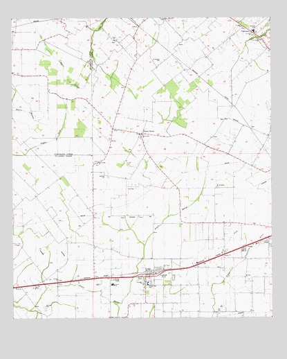
Lawtell, LA USGS Topographic Map
Click on map above to begin viewing in our Map Viewer.

This topographic map contains these locations and features:
Feature Name Type Latitude Longitude GNIS ID View Map
Bertrand CemeteryCemeteryN30.5605°W92.2060°560150View Map
Holy Family ChurchChurchN30.5205°W92.1773°1628698View Map
LawtellPopulated PlaceN30.5185°W92.1848°1627458View Map
Lawtell Census Designated PlaceCensusN30.5126°W92.1832°2586692View Map
Lawtell Elementary SchoolSchoolN30.5140°W92.2024°552620View Map
Lawtell Gas FieldOilfieldN30.5030°W92.1515°552621View Map
Lawtell Head Start Center SchoolSchoolN30.5175°W92.2002°2600234View Map
Lawtell High SchoolSchoolN30.5146°W92.2018°1629694View Map
Lawtell Post OfficePost OfficeN30.5177°W92.1829°1631983View Map
LedouxPopulated PlaceN30.6191°W92.1901°1627465View Map
Mount Hope ChurchChurchN30.5174°W92.1385°1627712View Map
Mount Triumphant ChurchChurchN30.5546°W92.1515°1627721View Map
Mount Zion ChurchChurchN30.5169°W92.2282°1628548View Map
New Bethel ChurchChurchN30.6171°W92.1312°1627759View Map
Northwest High SchoolSchoolN30.5781°W92.1892°2493458View Map
Parish Governing Authority District 1CivilN30.5418°W92.1930°1929758View Map
Parish Governing Authority District 3CivilN30.5589°W92.1473°1929975View Map
Pitre CemeteryCemeteryN30.5552°W92.1921°1627940View Map
PlaisancePopulated PlaceN30.6124°W92.1262°1627942View Map
Plaisance Elementary SchoolSchoolN30.6190°W92.1330°552648View Map
Plaisance High SchoolSchoolN30.6196°W92.1326°1629753View Map
Prairie RondePopulated PlaceN30.5769°W92.1885°1627998View Map
Prairie Ronde ChurchChurchN30.5646°W92.2090°1627999View Map
Prairie SchoolSchoolN30.6158°W92.2010°1628000View Map
Sacred Heart ChurchChurchN30.5755°W92.1882°1628703View Map
Saint Andrews CemeteryCemeteryN30.6074°W92.1782°1628094View Map
Saint Anns Catholic ChurchChurchN30.5132°W92.2387°2602372View Map
Saint Anthony ChurchChurchN30.5727°W92.1590°1628096View Map
Saint Bridget ChurchChurchN30.5155°W92.1868°1628704View Map
Saint Joseph ChurchChurchN30.6185°W92.1343°1628705View Map
Saint Landry Parish Fire District 3 Station 2BuildingN30.5189°W92.1809°2332489View Map
Saint Marks ChurchChurchN30.6216°W92.1387°1628136View Map
True Fellowship Missionary Baptist ChurchChurchN30.6125°W92.1253°2602901View Map
VeaziePopulated PlaceN30.5296°W92.1390°1628418View Map
West Fork Bayou Plaquemine BruleStreamN30.5166°W92.1482°1628472View Map
Whitaker Ultralight FlightparkAirportN30.5894°W92.2316°2717359View Map

Note: Coordinates in the location and feature list above are referenced to NAD83 datum.


Copyright (C) 2008-2024 Ryan Niemi / Sunset Dynamics ... All Rights Reserved