TopoQuest Logo
Do you find TopoQuest useful?
Help keep TopoQuest running and adding new maps/features by donating!
Bitcoin:  19c7KJd3qBynnjoSw5npx9KScwjBe4ifkT
Litecoin:  LXs6TkuXGGXo1vDsWCkWVdjQX94eUKd6ui
Home View Maps Find Maps Find Places Resources & Links


Tate Cove, Louisiana Topographic Map

USGS Map Title: Tate Cove, LA
USGS Map MRC: 30092F2
DRG (GeoTIFF) Download: o30092f2.tif


Neighboring USGS Topographic Map Quads:


  Saint Landry, LA  
30092G3
 

  Whiteville, LA  
30092G2
 

  Morrow, LA  
30092G1
 

  Ville Platte, LA  
30092F3
 

  Tate Cove, LA  
30092F2
 

  Beggs, LA  
30092F1
 

  Chataignier, LA  
30092E3
 

  Lawtell, LA  
30092E2
 

  Opelousas, LA  
30092E1


Map MRC Location:

N31°
W93°
N31°
W92°
H8 H7 H6 H5 H4 H3 H2 H1
G8 G7 G6 G5 G4 G3 G2 G1
F8 F7 F6 F5 F4 F3 F2 F1
E8 E7 E6 E5 E4 E3 E2 E1
D8 D7 D6 D5 D4 D3 D2 D1
C8 C7 C6 C5 C4 C3 C2 C1
B8 B7 B6 B5 B4 B3 B2 B1
A8 A7 A6 A5 A4 A3 A2 A1
N30°
W93°
N30°
W92°

Tate Cove, LA USGS 1:24K Topographic Map Preview:
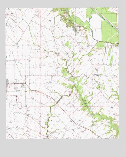
Tate Cove, LA USGS Topographic Map
Click on map above to begin viewing in our Map Viewer.

This topographic map contains these locations and features:
Feature Name Type Latitude Longitude GNIS ID View Map
Bayou Grand LouisStreamN30.6258°W92.2043°559968View Map
Bayou Grand Louis Gas FieldOilfieldN30.6766°W92.2085°545680View Map
Bayou Petite PasseStreamN30.6738°W92.1721°560048View Map
Bel Aire Cove Volunteer Fire DepartmentBuildingN30.6537°W92.2258°2691666View Map
Belair CovePopulated PlaceN30.6485°W92.2265°553579View Map
Cen-Tex Landing StripAirportN30.6424°W92.1704°552577View Map
Deville CemeteryCemeteryN30.6521°W92.2254°542114View Map
Earl Fontenot Junior Pond DamDamN30.7285°W92.1735°556850View Map
Evangeline Parish Sheriff's OfficeBuildingN30.6499°W92.2286°2334003View Map
FaubourgPopulated PlaceN30.7141°W92.1690°560786View Map
Faubourg Volunteer Fire DepartmentBuildingN30.7158°W92.1951°2691689View Map
Fontenots PondReservoirN30.7291°W92.1733°556851View Map
Frilot CovePopulated PlaceN30.6269°W92.2048°542116View Map
Grand PrairiePopulated PlaceN30.6833°W92.1476°560882View Map
Grand Prairie ChurchChurchN30.6766°W92.1462°560883View Map
Grand Prairie Elementary SchoolSchoolN30.6852°W92.1484°552608View Map
La Petite Airdrome (historical)AirportN30.6294°W92.1879°1632905View Map
Lafleur CemeteryCemeteryN30.6410°W92.2457°542117View Map
Macedonia Baptist ChurchChurchN30.6330°W92.2268°554947View Map
Morhorm ChurchChurchN30.6258°W92.1376°1627678View Map
New Hope Missionary Baptist ChurchChurchN30.6794°W92.2023°555473View Map
Old Grand Prairie CemeteryCemeteryN30.6857°W92.1537°1628702View Map
Parish Governing Authority District 10CivilN30.7406°W92.2467°1929780View Map
Parish Governing Authority District 4CivilN30.6422°W92.1357°1930034View Map
Parish Governing Authority District 9CivilN30.6975°W92.2099°1930270View Map
Sacred Heart ChapelChurchN30.6455°W92.2265°538777View Map
Saint Andrews ChurchChurchN30.6252°W92.1757°1628095View Map
Saint Landry Parish Fire District 3 Station 6BuildingN30.6683°W92.1476°2691843View Map
Saint Peter ChurchChurchN30.6771°W92.1457°1628706View Map
Soileaus CemeteryCemeteryN30.6785°W92.2023°542122View Map
Tate CovePopulated PlaceN30.7441°W92.2471°539793View Map
True Vine ChurchChurchN30.6846°W92.1287°1628385View Map
Young CemeteryCemeteryN30.6494°W92.2046°542123View Map

Note: Coordinates in the location and feature list above are referenced to NAD83 datum.


Copyright (C) 2008-2024 Ryan Niemi / Sunset Dynamics ... All Rights Reserved