TopoQuest Logo
Do you find TopoQuest useful?
Help keep TopoQuest running and adding new maps/features by donating!
Bitcoin:  19c7KJd3qBynnjoSw5npx9KScwjBe4ifkT
Litecoin:  LXs6TkuXGGXo1vDsWCkWVdjQX94eUKd6ui
Home View Maps Find Maps Find Places Resources & Links


Beggs, Louisiana Topographic Map

USGS Map Title: Beggs, LA
USGS Map MRC: 30092F1
DRG (GeoTIFF) Download: o30092f1.tif


Neighboring USGS Topographic Map Quads:


  Whiteville, LA  
30092G2
 

  Morrow, LA  
30092G1
 

  Bayou Jack, LA  
30091G8
 

  Tate Cove, LA  
30092F2
 

  Beggs, LA  
30092F1
 

  Palmetto, LA  
30091F8
 

  Lawtell, LA  
30092E2
 

  Opelousas, LA  
30092E1
 

  Port Barre, LA  
30091E8


Map MRC Location:

N31°
W93°
N31°
W92°
H8 H7 H6 H5 H4 H3 H2 H1
G8 G7 G6 G5 G4 G3 G2 G1
F8 F7 F6 F5 F4 F3 F2 F1
E8 E7 E6 E5 E4 E3 E2 E1
D8 D7 D6 D5 D4 D3 D2 D1
C8 C7 C6 C5 C4 C3 C2 C1
B8 B7 B6 B5 B4 B3 B2 B1
A8 A7 A6 A5 A4 A3 A2 A1
N30°
W93°
N30°
W92°

Beggs, LA USGS 1:24K Topographic Map Preview:
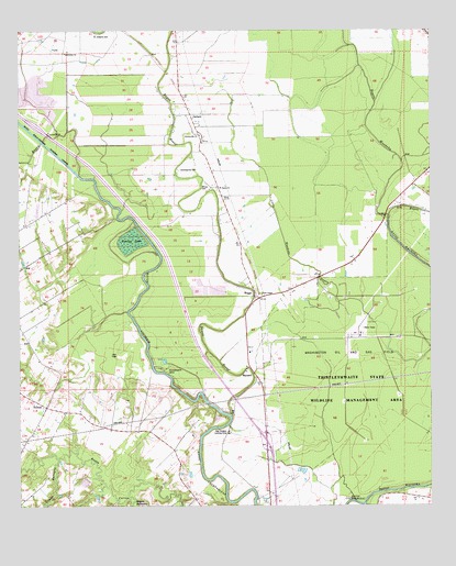
Beggs, LA USGS Topographic Map
Click on map above to begin viewing in our Map Viewer.

This topographic map contains these locations and features:
Feature Name Type Latitude Longitude GNIS ID View Map
Bayou BelleviewStreamN30.6252°W92.0910°559866View Map
Bayou BoeufStreamN30.6491°W92.0610°559877View Map
Bayou CocodrieStreamN30.6488°W92.0610°559911View Map
Bayou WaukshaStreamN30.6258°W92.0196°560109View Map
Begg Post Office (historical)Post OfficeN30.6796°W92.0535°1631961View Map
BeggsPopulated PlaceN30.6805°W92.0529°560132View Map
Chimleyville CemeteryCemeteryN30.7138°W92.0765°560419View Map
Chimleyville ChurchChurchN30.7233°W92.0696°560420View Map
Coulee GarrigueStreamN30.6383°W92.1135°560492View Map
Dry BayouStreamN30.7010°W92.0126°560656View Map
GarlandPopulated PlaceN30.7271°W92.0723°560817View Map
Grassy LakeLakeN30.6947°W92.0910°560892View Map
Macedonia ChurchChurchN30.7441°W92.1110°1628700View Map
MaclandPopulated PlaceN30.6594°W92.0532°1628701View Map
Saint Agnes ChurchChurchN30.7094°W92.0646°1628092View Map
Saint Josephs CemeteryCemeteryN30.7496°W92.1018°1628129View Map
Saint Landry Parish Fire District 3 Station 7BuildingN30.6794°W92.0537°2691718View Map
SoileauPopulated PlaceN30.6513°W92.1168°1628249View Map
Star Dusters AirportAirportN30.6442°W92.0618°1633001View Map
Thistlethwaite CampLocaleN30.6608°W92.0815°1628707View Map
Union ChapelChurchN30.6805°W92.0515°1628708View Map
Ward FiveCivilN30.6391°W92.0787°1628608View Map
Washington Oil and Gas FieldOilfieldN30.6602°W92.0062°1628444View Map
Whipp CemeteryCemeteryN30.7096°W92.0684°1628709View Map

Note: Coordinates in the location and feature list above are referenced to NAD83 datum.


Copyright (C) 2008-2025 Ryan Niemi / Sunset Dynamics ... All Rights Reserved