TopoQuest Logo
Do you find TopoQuest useful?
Help keep TopoQuest running and adding new maps/features by donating!
Bitcoin:  19c7KJd3qBynnjoSw5npx9KScwjBe4ifkT
Litecoin:  LXs6TkuXGGXo1vDsWCkWVdjQX94eUKd6ui
Home View Maps Find Maps Find Places Resources & Links


Leadbetter Island, Maine Topographic Map

USGS Map Title: Leadbetter Island, ME
USGS Map MRC: 44068A8
DRG (GeoTIFF) Download: o44068a8.tif


Neighboring USGS Topographic Map Quads:


  Camden, ME  
44069B1
 

  North Haven West, ME  
44068B8
 

  North Haven East, ME  
44068B7
 

  Rockland, ME  
44069A1
 

  Leadbetter Island, ME  
44068A8
 

  Vinalhaven, ME  
44068A7
 

  Hewett Island, ME  
43069H1


Map MRC Location:

N45°
W69°
N45°
W68°
H8 H7 H6 H5 H4 H3 H2 H1
G8 G7 G6 G5 G4 G3 G2 G1
F8 F7 F6 F5 F4 F3 F2 F1
E8 E7 E6 E5 E4 E3 E2 E1
D8 D7 D6 D5 D4 D3 D2 D1
C8 C7 C6 C5 C4 C3 C2 C1
B8 B7 B6 B5 B4 B3 B2 B1
A8 A7 A6 A5 A4 A3 A2 A1
N44°
W69°
N44°
W68°

Leadbetter Island, ME USGS 1:24K Topographic Map Preview:
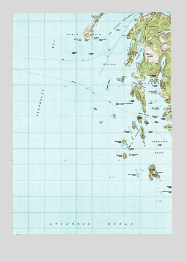
Leadbetter Island, ME USGS Topographic Map
Click on map above to begin viewing in our Map Viewer.

This topographic map contains these locations and features:
Feature Name Type Latitude Longitude GNIS ID View Map
Big Garden IslandIslandN44.0523°W68.9120°580398View Map
Big White IslandIslandN44.0440°W68.9117°580387View Map
Browns HeadCapeN44.1117°W68.9106°581396View Map
Browns Head Light StationLocaleN44.1120°W68.9092°1909424View Map
Calderwood RockBarN44.1220°W68.9081°581698View Map
Carver LedgeBarN44.0667°W68.8972°2677996View Map
Cedar IslandIslandN44.0626°W68.8964°563721View Map
Clam IslandIslandN44.0751°W68.9078°1909443View Map
Clam LedgeBarN44.0751°W68.9070°580397View Map
Conway PointCapeN44.0887°W68.8903°564307View Map
Crabtree PointCapeN44.1101°W68.9373°564444View Map
Crabtree Point LedgeBarN44.1095°W68.9325°580399View Map
Crane IslandIslandN44.0559°W68.8986°564490View Map
Crockett CoveBayN44.1012°W68.9017°564535View Map
Crockett PointCapeN44.0959°W68.9117°564539View Map
Cross Island LedgeBarN44.1231°W68.9061°581717View Map
Crotch IslandIslandN44.0604°W68.9064°564580View Map
Deadman LedgeBarN44.0256°W68.8759°579960View Map
Dog Fish BeaconLocaleN44.0959°W68.9284°580394View Map
Dogfish IslandIslandN44.0876°W68.9145°565173View Map
Dogfish LedgesBarN44.0842°W68.9231°580395View Map
Drunkard LedgeBarN44.1023°W68.9536°580401View Map
Dyer IslandIslandN44.0595°W68.8789°565468View Map
Dyer PondLakeN44.1018°W68.8924°565478View Map
Fiddlehead IslandIslandN44.0798°W68.8892°566123View Map
Fiddler LedgeBenchN44.1017°W68.9395°578921View Map
Fiddlers LedgeBarN44.1015°W68.9395°580393View Map
Fish HeadCapeN44.1206°W68.9031°566200View Map
Flat IslandIslandN44.0740°W68.8886°580383View Map
Fox EarsBarN44.1170°W68.9131°581743View Map
Fox RocksIslandN44.1079°W68.8864°566524View Map
Garden IslandIslandN44.0481°W68.9078°580389View Map
Green IslandIslandN44.0729°W68.9164°567214View Map
Green LedgeBarN44.0662°W68.9214°567241View Map
Gundell IslandIslandN44.0642°W68.8800°567396View Map
Hall IslandIslandN44.0862°W68.8886°567506View Map
Harbor IslandIslandN44.0570°W68.8925°580392View Map
Hurricane IslandIslandN44.0351°W68.8909°568504View Map
Hurricane SoundBayN44.0448°W68.8870°568511View Map
Inner Bay LedgesBarN44.0784°W68.9525°581783View Map
James and Willies LedgeBarN44.0237°W68.8831°580390View Map
Lawrys IslandIslandN44.0648°W68.8995°579980View Map
Lawrys LedgeIslandN44.0504°W68.8859°579981View Map
Lawrys NarrowsGutN44.0667°W68.8967°579982View Map
Leadbetter IslandIslandN44.0787°W68.9017°569421View Map
Leadbetter NarrowsChannelN44.0837°W68.9017°569422View Map
Little Hurricane IslandIslandN44.0337°W68.9023°569837View Map
Little White IslandIslandN44.0448°W68.9075°580388View Map
Long CoveBayN44.0940°W68.8839°570190View Map
Medric RockBarN44.0629°W68.9314°571110View Map
Middle MountainSummitN44.1009°W68.8888°571255View Map
Narrow Place BeachBeachN44.1220°W68.9331°580404View Map
Ohio IslandIslandN44.0704°W68.8906°572675View Map
Outward Bound SchoolSchoolN44.0348°W68.8867°580391View Map
Perry LedgeBarN44.0081°W68.9311°581857View Map
Pole IslandIslandN44.0634°W68.8878°580381View Map
Rasberry IslandIslandN44.0662°W68.8853°580382View Map
Sand-in-Point LedgeBarN44.1095°W68.9450°580400View Map
Seal LedgeBarN44.0709°W68.9359°580396View Map
South Big Garden IslandIslandN44.0501°W68.9134°1909636View Map
Spectacle IslandIslandN44.0542°W68.9056°576000View Map
Stand-in PointCapeN44.1106°W68.9431°576235View Map
Sugar LoavesBarN44.1148°W68.9161°576502View Map
Tiptoe MountainSummitN44.1018°W68.9045°577129View Map
Turnip IslandIslandN44.0840°W68.8886°580384View Map
White IslandIslandN44.0531°W68.9064°580014View Map
Young PointCapeN44.1231°W68.9000°578797View Map
Youngs CoveBayN44.1237°W68.8867°580385View Map

Note: Coordinates in the location and feature list above are referenced to NAD83 datum.


Copyright (C) 2008-2024 Ryan Niemi / Sunset Dynamics ... All Rights Reserved