TopoQuest Logo
Do you find TopoQuest useful?
Help keep TopoQuest running and adding new maps/features by donating!
Bitcoin:  19c7KJd3qBynnjoSw5npx9KScwjBe4ifkT
Litecoin:  LXs6TkuXGGXo1vDsWCkWVdjQX94eUKd6ui
Home View Maps Find Maps Find Places Resources & Links


Vinalhaven, Maine Topographic Map

USGS Map Title: Vinalhaven, ME
USGS Map MRC: 44068A7
DRG (GeoTIFF) Download: o44068a7.tif


Neighboring USGS Topographic Map Quads:


  North Haven West, ME  
44068B8
 

  North Haven East, ME  
44068B7
 

  Deer Isle, ME  
44068B6
 

  Leadbetter Island, ME  
44068A8
 

  Vinalhaven, ME  
44068A7
 

  Isle Au Haut West, ME  
44068A6


Map MRC Location:

N45°
W69°
N45°
W68°
H8 H7 H6 H5 H4 H3 H2 H1
G8 G7 G6 G5 G4 G3 G2 G1
F8 F7 F6 F5 F4 F3 F2 F1
E8 E7 E6 E5 E4 E3 E2 E1
D8 D7 D6 D5 D4 D3 D2 D1
C8 C7 C6 C5 C4 C3 C2 C1
B8 B7 B6 B5 B4 B3 B2 B1
A8 A7 A6 A5 A4 A3 A2 A1
N44°
W69°
N44°
W68°

Vinalhaven, ME USGS 1:24K Topographic Map Preview:
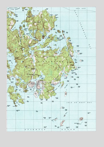
Vinalhaven, ME USGS Topographic Map
Click on map above to begin viewing in our Map Viewer.

This topographic map contains these locations and features:
Feature Name Type Latitude Longitude GNIS ID View Map
Arey CoveBayN44.0534°W68.7961°561285View Map
Arey LedgesBarN44.0201°W68.8336°561287View Map
Arey NeckCapeN44.0554°W68.7911°561288View Map
Areys Neck WoodsAreaN44.0570°W68.7911°1909415View Map
Armburst Hill Wildlife PreserveParkN44.0448°W68.8300°1909416View Map
Ash Tree PointCapeN44.1159°W68.8081°580466View Map
Barley HillSummitN44.0692°W68.7832°561614View Map
Barton IslandIslandN44.0651°W68.8742°561682View Map
Basin High MountainSummitN44.0731°W68.8576°580420View Map
Benny LedgeBarN44.0995°W68.7917°580460View Map
Big Hen IslandIslandN44.1001°W68.8014°1909421View Map
Big ShoalBarN44.0162°W68.8348°581684View Map
Bluff HeadIslandN44.1001°W68.7964°562615View Map
Boathouse CoveBayN44.1140°W68.8220°580471View Map
Bob Meadow PointCapeN44.0587°W68.7842°580457View Map
Booth Quarry PondLakeN44.0526°W68.8058°580452View Map
Booths Quarry (historical)MineN44.0520°W68.8056°1909422View Map
Brimstone IslandIslandN44.0129°W68.7695°562977View Map
Broom IslandIslandN44.1056°W68.8525°563024View Map
Browns IslandIslandN44.0804°W68.7767°563076View Map
Browns LedgeBarN44.0856°W68.7773°580456View Map
Buffalo LedgeBarN44.0045°W68.7792°580433View Map
Bunker LedgeBarN44.0270°W68.8186°581697View Map
Burnt IslandIslandN44.0840°W68.8136°579954View Map
Burying IslandIslandN44.0498°W68.8661°580424View Map
Calderwood NeckIslandN44.1042°W68.8295°563344View Map
Calderwood PointCapeN44.0642°W68.7761°563345View Map
Carrying Place BridgeBridgeN44.0919°W68.8314°580447View Map
Carver CoveBayN44.1195°W68.8356°563649View Map
Carver's Harbor Post OfficePost OfficeN44.0477°W68.8333°1909671View Map
Carvers CoveBayN44.0459°W68.8106°580442View Map
Carvers HarborBayN44.0423°W68.8364°563650View Map
Carvers IslandIslandN44.0237°W68.7975°563651View Map
Carvers PondLakeN44.0534°W68.8299°563652View Map
Cedar PondLakeN44.0651°W68.8492°563732View Map
Channel LedgeBarN44.0109°W68.8203°580435View Map
Channel RockBarN44.0131°W68.8200°563839View Map
Cherry Tree CoveBayN44.0623°W68.7784°580450View Map
Clam CoveBayN44.0420°W68.8081°580440View Map
Clam IslandIslandN44.1084°W68.8595°580403View Map
Clam LedgesBarN44.0451°W68.7911°580437View Map
Clayters BeachBeachN44.0326°W68.8253°580427View Map
Colt LedgeBarN44.0129°W68.8367°581709View Map
Coombs NeckCapeN44.0834°W68.7853°564335View Map
Cooms HillSummitN44.0880°W68.7862°564331View Map
Crosby LedgeBarN44.0384°W68.7853°581716View Map
Cummins CemeteryCemeteryN44.0466°W68.8210°580445View Map
Cunning RockBarN44.0640°W68.7753°580458View Map
Davids IslandIslandN44.0923°W68.8061°580462View Map
Days CoveBayN44.0556°W68.8289°580448View Map
Days PointCapeN44.0559°W68.8256°580443View Map
Deep CoveBayN44.0912°W68.7856°564946View Map
Diamond RockBarN44.0181°W68.7611°565086View Map
Diamond Rock LedgeBarN44.0254°W68.7686°581723View Map
Dog PointCapeN44.0548°W68.8720°580019View Map
Duck IslandIslandN44.0715°W68.7798°579961View Map
Dushane HillSummitN44.0477°W68.8066°1909454View Map
Dyers PondLakeN44.0954°W68.8523°580417View Map
Eastern LedgeBarN44.0059°W68.7659°580446View Map
Fish HookBayN44.0923°W68.8350°580481View Map
Fish House CoveBayN44.0615°W68.7825°580449View Map
Folly LedgeBarN44.0298°W68.8473°566360View Map
Folly PondLakeN44.0766°W68.8483°566361View Map
Green IslandIslandN44.0692°W68.7753°567213View Map
Green LedgeBarN44.0337°W68.8439°582255View Map
Green LedgeBarN44.0440°W68.7820°582256View Map
Greens IslandIslandN44.0362°W68.8661°567212View Map
Greens Island CoveBayN44.0392°W68.8636°1909475View Map
Greer IslandIslandN44.0545°W68.7848°580453View Map
Griffin LedgeBarN44.0476°W68.7778°580439View Map
Grindstone LedgeBarN44.1242°W68.8631°581755View Map
Gull BarBarN44.1062°W68.8061°580470View Map
Gully BrookStreamN44.1056°W68.8653°580412View Map
Gunning RockIslandN44.0645°W68.7750°1909477View Map
Halibut LedgeBarN44.0448°W68.7753°580438View Map
Hay IslandIslandN44.0865°W68.8078°567798View Map
Hay IslandsIslandN44.0167°W68.7917°580434View Map
Hen IslandIslandN44.0415°W68.8314°580421View Map
Hen IslandsIslandN44.0992°W68.8067°582258View Map
Heron NeckCapeN44.0259°W68.8631°567963View Map
Heron Neck LedgeBarN44.0206°W68.8625°567964View Map
Heron Neck Light StationLocaleN44.0254°W68.8620°1909480View Map
Hill CemeteryCemeteryN44.0956°W68.8595°580402View Map
Holden LedgeBarN44.0087°W68.7656°568184View Map
Holt PointCapeN44.1048°W68.8542°580415View Map
Hopkins PointCapeN44.1176°W68.8664°568254View Map
House LedgeBarN44.0540°W68.7770°568360View Map
Indian Camp BeachBeachN44.0667°W68.7800°580459View Map
Indian CreekBayN44.0384°W68.8286°568571View Map
Iron Point LedgeBarN44.1245°W68.8559°581786View Map
Island Community Medical CenterHospitalN44.0462°W68.8300°1909493View Map
Isle Au Haut MountainSummitN44.0629°W68.8421°568704View Map
Jennings CoveBayN44.1015°W68.8411°580477View Map
John Carver CemeteryCemeteryN44.0498°W68.8392°1909500View Map
Knubble LedgeBarN44.0073°W68.8153°581797View Map
Lane Family CemeteryCemeteryN44.0369°W68.8334°1909508View Map
Lane IslandIslandN44.0381°W68.8336°569368View Map
Lane LedgeBarN44.0040°W68.7998°1909509View Map
Lanes Island PreserveParkN44.0376°W68.8342°1909510View Map
Lawson Quarry PondLakeN44.0577°W68.8368°580422View Map
Lawsons Quarry (historical)MineN44.0567°W68.8350°1909513View Map
Lelands PointCapeN44.0951°W68.8361°580480View Map
Lincoln Elementary SchoolSchoolN44.0467°W68.8231°1909516View Map
Little Brimstone IslandIslandN44.0079°W68.7717°569710View Map
Little Hen IslandIslandN44.0995°W68.8056°1909517View Map
Little IslandIslandN44.1026°W68.8095°580469View Map
Little Smith IslandIslandN44.0917°W68.8025°580463View Map
Little Triangle LedgeBarN44.0565°W68.7686°581805View Map
Long PondLakeN44.0807°W68.8621°570275View Map
Lower LedgeBarN44.0056°W68.8084°580431View Map
Middle LedgeBarN44.0215°W68.7939°580430View Map
Mill CreekStreamN44.1029°W68.8592°580418View Map
Mill PondBayN44.1001°W68.8359°580478View Map
Mill PriviledgeBayN44.0995°W68.7917°580479View Map
Mill RiverGutN44.0990°W68.8475°571349View Map
Mink IslandIslandN44.0937°W68.7973°580464View Map
Mitten LedgeBarN44.0501°W68.7903°571479View Map
Mount Ephraim IslandIslandN44.0995°W68.8425°581631View Map
Mouse IslandIslandN44.0706°W68.8728°580423View Map
Mouse IslandIslandN44.1154°W68.8634°580856View Map
Murchs BrookStreamN44.1012°W68.8689°580416View Map
Narrows IslandIslandN44.0476°W68.7981°572048View Map
Neck IslandIslandN44.0959°W68.7942°580465View Map
Norton PointCapeN44.0398°W68.8492°572498View Map
Old Duke LedgesBarN44.0342°W68.8023°580441View Map
Old HarborBayN44.0512°W68.8675°572701View Map
Old Harbor PondLakeN44.0516°W68.8543°572702View Map
Old Horse LedgeBarN44.0045°W68.8239°580436View Map
Otter IslandIslandN44.0079°W68.7978°572820View Map
Otter Island LedgeBarN44.0040°W68.7925°580432View Map
Otter PondLakeN44.0703°W68.8537°572833View Map
Penobscot IslandIslandN44.0906°W68.8148°573179View Map
Perry CreekStreamN44.1142°W68.8648°573217View Map
Point LedgeBarN44.0287°W68.8278°582260View Map
Point LedgeBarN44.0573°W68.7795°582261View Map
Polly CoveBayN44.1162°W68.8384°580468View Map
Pooles Hill CemeteryCemeteryN44.0765°W68.7834°580454View Map
Potato IslandIslandN44.0398°W68.8392°573713View Map
Ram IslandIslandN44.0959°W68.7981°580461View Map
Red Lion IslandIslandN44.0534°W68.8267°580444View Map
Reindeer CoveBayN44.0459°W68.8675°1909580View Map
Roberts CemeteryCemeteryN44.0399°W68.8154°580426View Map
Roberts HarborBayN44.0434°W68.8048°574299View Map
Roberts IslandIslandN44.0120°W68.8053°579998View Map
Round NeckCapeN44.0326°W68.8189°580428View Map
Round PondLakeN44.0831°W68.8513°574495View Map
Round RockBarN44.0295°W68.8231°574531View Map
Salt Works CoveBayN44.1167°W68.8128°580475View Map
Sand CoveBayN44.0434°W68.8450°574824View Map
Sands CoveBayN44.0379°W68.8717°1909623View Map
Seal BayBayN44.0948°W68.7986°1909628View Map
Seal BayBayN44.0892°W68.8039°575083View Map
Seal CoveBayN44.1037°W68.8653°575089View Map
Shag RockIslandN44.0129°W68.7764°581898View Map
Sheep IslandIslandN44.0379°W68.7923°575338View Map
Sheep Island LedgeBarN44.0290°W68.7889°581899View Map
Shipwreck CoveBayN44.1223°W68.8478°580474View Map
Sister LedgeBarN44.0526°W68.7811°580451View Map
Smith CoveBayN44.0812°W68.8014°575618View Map
Smith HarborBayN44.0762°W68.7850°580455View Map
Smith IslandIslandN44.0706°W68.7711°575627View Map
Smith PointCapeN44.1109°W68.8631°582259View Map
Smith PointCapeN44.0431°W68.8414°582313View Map
Spectacle IslandIslandN44.1023°W68.8509°580473View Map
Starboard RockSummitN44.0944°W68.8232°576270View Map
Stepping Stone BrookStreamN44.0934°W68.8559°580482View Map
Stoddart IslandIslandN44.0781°W68.7734°576374View Map
Talbot IslandIslandN44.0404°W68.8628°580425View Map
Ten Cent IslandIslandN44.0945°W68.8178°580476View Map
Thayer PointCapeN44.1223°W68.8206°580467View Map
The BasinBayN44.0729°W68.8698°576751View Map
The BreakersBarN44.0179°W68.8467°581693View Map
The ReachBayN44.0451°W68.8634°576910View Map
The Swimming PoolBayN44.1156°W68.8464°580472View Map
Town of VinalhavenCivilN44.0069°W68.8124°582782View Map
Triangle LedgeBarN44.0531°W68.7664°581942View Map
Turning RockBarN44.0931°W68.8036°1909660View Map
Union Church of VinalhavenChurchN44.0481°W68.8309°1909662View Map
Vinal CoveBayN44.0787°W68.8411°577729View Map
Vinal FallsIslandN44.0854°W68.8417°580419View Map
VinalhavenPopulated PlaceN44.0481°W68.8317°577730View Map
Vinalhaven AirportAirportN44.0740°W68.8193°582241View Map
Vinalhaven Fire DepartmentBuildingN44.0472°W68.8361°2552766View Map
Vinalhaven Historical Society MuseumBuildingN44.0476°W68.8348°1909669View Map
Vinalhaven IslandIslandN44.0709°W68.8245°1909670View Map
Vinalhaven Police DepartmentBuildingN44.0459°W68.8366°2735920View Map
Vinalhaven Public LibraryBuildingN44.0485°W68.8313°1909672View Map
Vinalhaven SchoolSchoolN44.0487°W68.8214°1909668View Map
Winter HarborBayN44.0917°W68.8223°578603View Map
Wreck LedgeBarN44.0301°W68.8128°580429View Map
Yellow RockBarN44.0040°W68.8036°578757View Map
Zeke PointCapeN44.1231°W68.8528°578813View Map

Note: Coordinates in the location and feature list above are referenced to NAD83 datum.


Copyright (C) 2008-2024 Ryan Niemi / Sunset Dynamics ... All Rights Reserved