TopoQuest Logo
Do you find TopoQuest useful?
Help keep TopoQuest running and adding new maps/features by donating!
Bitcoin:  19c7KJd3qBynnjoSw5npx9KScwjBe4ifkT
Litecoin:  LXs6TkuXGGXo1vDsWCkWVdjQX94eUKd6ui
Home View Maps Find Maps Find Places Resources & Links


North Haven East, Maine Topographic Map

USGS Map Title: North Haven East, ME
USGS Map MRC: 44068B7
DRG (GeoTIFF) Download: o44068b7.tif


Neighboring USGS Topographic Map Quads:


  Islesboro, ME  
44068C8
 

  Cape Rosier, ME  
44068C7
 

  Sargentville, ME  
44068C6
 

  North Haven West, ME  
44068B8
 

  North Haven East, ME  
44068B7
 

  Deer Isle, ME  
44068B6
 

  Leadbetter Island, ME  
44068A8
 

  Vinalhaven, ME  
44068A7
 

  Isle Au Haut West, ME  
44068A6


Map MRC Location:

N45°
W69°
N45°
W68°
H8 H7 H6 H5 H4 H3 H2 H1
G8 G7 G6 G5 G4 G3 G2 G1
F8 F7 F6 F5 F4 F3 F2 F1
E8 E7 E6 E5 E4 E3 E2 E1
D8 D7 D6 D5 D4 D3 D2 D1
C8 C7 C6 C5 C4 C3 C2 C1
B8 B7 B6 B5 B4 B3 B2 B1
A8 A7 A6 A5 A4 A3 A2 A1
N44°
W69°
N44°
W68°

North Haven East, ME USGS 1:24K Topographic Map Preview:
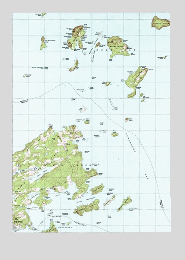
North Haven East, ME USGS Topographic Map
Click on map above to begin viewing in our Map Viewer.

This topographic map contains these locations and features:
Feature Name Type Latitude Longitude GNIS ID View Map
Apple Tree HillSummitN44.1499°W68.8404°580485View Map
Armstrong CoveBayN44.1442°W68.8467°580499View Map
Babbidge IslandIslandN44.1420°W68.7856°561386View Map
Babbidge Island LedgesBarN44.1384°W68.7834°580487View Map
Bald IslandIslandN44.1895°W68.7836°561509View Map
Banks CoveBayN44.1615°W68.8178°561563View Map
Barred IslandsIslandN44.2320°W68.8086°561633View Map
Bear IslandIslandN44.2201°W68.8259°561840View Map
Bear Island BeachBeachN44.2295°W68.8256°580519View Map
Beverage IslandIslandN44.1709°W68.8178°1909420View Map
Big Barred IslandIslandN44.2312°W68.8075°580523View Map
Big Green IslandIslandN44.1490°W68.7992°580749View Map
Big MountainSummitN44.2333°W68.7936°580515View Map
Birch IslandIslandN44.1306°W68.8417°562299View Map
Birch PointCapeN44.1304°W68.8434°580492View Map
Black LedgeBarN44.1340°W68.8000°580486View Map
Boy Scout IslandIslandN44.1640°W68.8070°580750View Map
Bradbury IslandIslandN44.2442°W68.7600°562846View Map
Bradstreet RockBarN44.1315°W68.8248°581692View Map
Brook BeachBeachN44.2287°W68.8184°580508View Map
Browns CemeteryCemeteryN44.1781°W68.8400°580504View Map
Browns CemeteryCemeteryN44.1402°W68.8732°563071View Map
Burnt IslandIslandN44.1498°W68.8089°563241View Map
Burnt IslandIslandN44.1879°W68.8170°563242View Map
Butter IslandIslandN44.2301°W68.7914°579955View Map
Calderwood IslandIslandN44.1426°W68.7986°563343View Map
Calderwood PointCapeN44.1267°W68.8450°563346View Map
Channel RockIslandN44.2134°W68.8136°563841View Map
Charley Browns PondLakeN44.1632°W68.8706°580495View Map
Compass IslandIslandN44.2142°W68.8681°564263View Map
Compass Island LedgeBarN44.2006°W68.8484°580501View Map
Cubby HoleBayN44.1454°W68.8584°564640View Map
Dagger IslandIslandN44.1829°W68.8059°564728View Map
Dagger LedgeBarN44.1870°W68.8073°564729View Map
Dobbin RockBarN44.1265°W68.8559°581725View Map
Double BeachBeachN44.2287°W68.8184°580521View Map
Downfall IslandIslandN44.1798°W68.8070°576794View Map
Driftwood BeachBeachN44.2379°W68.8270°580528View Map
Eagle IslandIslandN44.2126°W68.7767°565491View Map
Eagle Island LightBuildingN44.2176°W68.7678°1911546View Map
Eaton CemeteryCemeteryN44.2187°W68.8242°1911564View Map
Fish PointCapeN44.1382°W68.8508°579965View Map
Fish Point LedgeBarN44.1351°W68.8639°580489View Map
Fling IslandIslandN44.2101°W68.8000°566308View Map
Fox Islands ThorofareChannelN44.1315°W68.8534°566516View Map
Fresh PondLakeN44.1587°W68.8514°566586View Map
Frye CemeteryCemeteryN44.1715°W68.8325°580751View Map
Goose RocksPopulated PlaceN44.1354°W68.8317°579346View Map
Goose Rocks LighthouseLocaleN44.1354°W68.8309°580483View Map
Grass LedgeBarN44.1954°W68.7961°567070View Map
Grass LedgeBarN44.2190°W68.8520°567071View Map
Great Spruce Head IslandIslandN44.2362°W68.8245°567182View Map
Harbor BeachBeachN44.2354°W68.8203°580518View Map
Hardhead IslandIslandN44.2248°W68.7536°567597View Map
Hog IslandIslandN44.1781°W68.8178°568156View Map
Horsehead IslandIslandN44.2495°W68.8498°568295View Map
Indian PointCapeN44.1442°W68.8281°568592View Map
Iron PointCapeN44.1270°W68.8603°568675View Map
J O Browns Ferry DockLocaleN44.1270°W68.8723°1909498View Map
Kent CemeteryCemeteryN44.1490°W68.8459°580498View Map
Kent CoveBayN44.1470°W68.8353°569124View Map
Kent LedgeBarN44.1367°W68.8453°580494View Map
Lighthouse BeachBeachN44.2179°W68.7720°580510View Map
Little Barred IslandIslandN44.2326°W68.8109°580530View Map
Little Green IslandIslandN44.1440°W68.8006°580488View Map
Little MountainSummitN44.2297°W68.7851°580517View Map
Little Spruce Head IslandIslandN44.2334°W68.8495°570075View Map
Little ThorofareChannelN44.1429°W68.8192°570084View Map
Lobster LedgeBarN44.1262°W68.8656°580491View Map
Long PointCapeN44.2109°W68.7853°580507View Map
Marsh CoveBayN44.1767°W68.8236°570803View Map
Middle RockBarN44.2337°W68.7609°580512View Map
Mill StreamBayN44.1598°W68.8731°580410View Map
Mount NeboSummitN44.1331°W68.8728°580500View Map
Mullen CoveBayN44.1542°W68.8164°571975View Map
Mullen HeadCapeN44.1584°W68.8106°571976View Map
Mullen Head ParkParkN44.1606°W68.8111°1909546View Map
North HavenPopulated PlaceN44.1281°W68.8742°572346View Map
North Haven Emergency Medical ServicesBuildingN44.1444°W68.8712°2666822View Map
North Haven FerryLocaleN44.1273°W68.8739°1909551View Map
North Haven IslandIslandN44.1529°W68.8731°580411View Map
North Haven Post OfficePost OfficeN44.1278°W68.8733°1909553View Map
North Haven Public LibraryBuildingN44.1278°W68.8734°1909552View Map
North Haven Volunteer Fire DepartmentBuildingN44.1443°W68.8713°2552779View Map
North Haven Yacht ClubLocaleN44.1273°W68.8742°1909554View Map
North PointCapeN44.2420°W68.8198°580527View Map
North Point BeachBeachN44.2404°W68.8181°580535View Map
Oak HillSummitN44.1811°W68.8269°572580View Map
Oak IslandIslandN44.1956°W68.8189°572612View Map
Orchard BeachBeachN44.2329°W68.7870°580516View Map
Peak IslandIslandN44.2376°W68.8050°580531View Map
Pease IslandIslandN44.1470°W68.8323°580484View Map
Pond Hole LedgesBarN44.1884°W68.8250°580502View Map
Pond SwampSwampN44.1556°W68.8617°580497View Map
Post Office LedgeBarN44.1262°W68.8684°580490View Map
Purgatory SwampSwampN44.1748°W68.8517°580505View Map
Quinn CemeteryCemeteryN44.2126°W68.7750°580511View Map
Salt PointCapeN44.1845°W68.8320°580503View Map
Salt PondLakeN44.1616°W68.8563°580496View Map
Scrag IslandIslandN44.2237°W68.8361°575062View Map
Seaview CemeteryCemeteryN44.1478°W68.8728°1909629View Map
Sheep IslandIslandN44.1806°W68.7948°575341View Map
Sloop IslandIslandN44.2073°W68.8148°575554View Map
Sloop Island LedgeBarN44.2059°W68.8189°575555View Map
South PointCapeN44.2267°W68.8184°580520View Map
Spoon LedgeBarN44.2015°W68.8295°576065View Map
Steep Bank BeachBeachN44.2306°W68.8289°580526View Map
Stimpsons IslandIslandN44.1390°W68.8181°581496View Map
Stimpsons RockBarN44.1345°W68.8250°581924View Map
Sunken Black LedgeBarN44.1315°W68.8017°581926View Map
The Brook BeachBeachN44.2154°W68.7792°580509View Map
The Chain LinksIslandN44.2254°W68.8186°580522View Map
The HeadSummitN44.2398°W68.8234°580534View Map
The NubbleCapeN44.2262°W68.7817°580513View Map
The NubbleSummitN44.2315°W68.8291°580524View Map
The PorcupinesIslandN44.2006°W68.7714°576909View Map
The SugarloafIslandN44.2359°W68.8031°580532View Map
The Wood LandBayN44.2073°W68.7770°580506View Map
The Wood LandingLocaleN44.2070°W68.7773°1912011View Map
Three Island BeachBeachN44.2356°W68.8278°580529View Map
Walton BeachBeachN44.2326°W68.8306°580525View Map
Waterman CoveBayN44.1384°W68.8606°577890View Map
Waterman LedgeBarN44.1315°W68.8534°581953View Map
Watson Airport (historical)AirportN44.1779°W68.8342°582195View Map
Watson Landing Strip (historical)AirportN44.1759°W68.8345°580854View Map
Webster HeadCapeN44.1840°W68.8461°577959View Map
West PointCapeN44.2251°W68.7961°580514View Map
Widow IslandIslandN44.1301°W68.8314°578448View Map
Witherspoon CemeteryCemeteryN44.2284°W68.7889°1912104View Map

Note: Coordinates in the location and feature list above are referenced to NAD83 datum.


Copyright (C) 2008-2024 Ryan Niemi / Sunset Dynamics ... All Rights Reserved