TopoQuest Logo
Do you find TopoQuest useful?
Help keep TopoQuest running and adding new maps/features by donating!
Bitcoin:  19c7KJd3qBynnjoSw5npx9KScwjBe4ifkT
Litecoin:  LXs6TkuXGGXo1vDsWCkWVdjQX94eUKd6ui
Home View Maps Find Maps Find Places Resources & Links


Lebec, California Topographic Map

USGS Map Title: Lebec, CA
USGS Map MRC: 34118G7
DRG (GeoTIFF) Download: o34118g7.tif


Neighboring USGS Topographic Map Quads:


  Grapevine, CA  
34118H8
 

  Pastoria Creek, CA  
34118H7
 

  Winters Ridge, CA  
34118H6
 

  Frazier Mountain, CA  
34118G8
 

  Lebec, CA  
34118G7
 

  La Liebre Ranch, CA  
34118G6
 

  Alamo Mountain, CA  
34118F8
 

  Black Mountain, CA  
34118F7
 

  Liebre Mountain, CA  
34118F6


Map MRC Location:

N35°
W119°
N35°
W118°
H8 H7 H6 H5 H4 H3 H2 H1
G8 G7 G6 G5 G4 G3 G2 G1
F8 F7 F6 F5 F4 F3 F2 F1
E8 E7 E6 E5 E4 E3 E2 E1
D8 D7 D6 D5 D4 D3 D2 D1
C8 C7 C6 C5 C4 C3 C2 C1
B8 B7 B6 B5 B4 B3 B2 B1
A8 A7 A6 A5 A4 A3 A2 A1
N34°
W119°
N34°
W118°

Lebec, CA USGS 1:24K Topographic Map Preview:
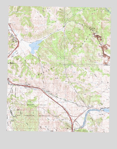
Lebec, CA USGS Topographic Map
Click on map above to begin viewing in our Map Viewer.

This topographic map contains these locations and features:
Feature Name Type Latitude Longitude GNIS ID View Map
109 Limestone QuarryMineN34.8481°W118.7711°2675037View Map
Bailey SubstationBuildingN34.7758°W118.7745°254436View Map
Bear CanyonValleyN34.8283°W118.8543°269720View Map
Castac LakeLakeN34.8351°W118.8439°270333View Map
Cement Rock QuarryMineN34.8325°W118.7606°2675422View Map
Circle Canyon CampgroundLocaleN34.7611°W118.8684°254433View Map
Crane CanyonValleyN34.8264°W118.8437°270682View Map
Freeman Canyon Cultural PreserveReserveN34.7525°W118.8436°2741207View Map
Freeman OverlookLocaleN34.7714°W118.8634°254533View Map
GormanPopulated PlaceN34.7961°W118.8526°271369View Map
Gorman Cultural PreserveReserveN34.7639°W118.8336°2741208View Map
Gorman Elementary SchoolSchoolN34.7925°W118.8538°271373View Map
Gorman SubstationBuildingN34.7900°W118.8262°254437View Map
Holland Summit (historical)Populated PlaceN34.8005°W118.8734°1693280View Map
Hungry Valley State Vehicular Recreation AreaParkN34.7503°W118.8593°254524View Map
Kern County Fire Department Station 56 LebecBuildingN34.8329°W118.8649°2665393View Map
LebecPopulated PlaceN34.8416°W118.8648°272011View Map
Lebec Post OfficePost OfficeN34.8423°W118.8656°2769443View Map
Los Angeles County Fire Department Station 77BuildingN34.7594°W118.7973°2665143View Map
Lower Quail CanalCanalN34.7672°W118.7787°273142View Map
Mount PinesSummitN34.7814°W118.8704°275513View Map
Old Bailey Ranch (historical)LocaleN34.7714°W118.7620°275510View Map
Quail Lake Inn (historical)BuildingN34.7755°W118.7737°1693281View Map
Quail Lake SchoolSchoolN34.7728°W118.7740°276733View Map
Quail Lake SchoolSchoolN34.7739°W118.7743°275511View Map
Quail PassGapN34.7553°W118.8326°254434View Map
Redtail Canyon CampgroundLocaleN34.7655°W118.8679°254432View Map
Sky RanchLocaleN34.7672°W118.7970°275512View Map
Tejon Guard Station (historical)LocaleN34.7944°W118.8690°1693282View Map
Tejon LookoutLocaleN34.8030°W118.8154°274053View Map
Trust Me CanyonValleyN34.7603°W118.8006°254435View Map
Vortog Radio Navigation Station (historical)TowerN34.8041°W118.8609°1654867View Map

Note: Coordinates in the location and feature list above are referenced to NAD83 datum.


Copyright (C) 2008-2025 Ryan Niemi / Sunset Dynamics ... All Rights Reserved