TopoQuest Logo
Do you find TopoQuest useful?
Help keep TopoQuest running and adding new maps/features by donating!
Bitcoin:  19c7KJd3qBynnjoSw5npx9KScwjBe4ifkT
Litecoin:  LXs6TkuXGGXo1vDsWCkWVdjQX94eUKd6ui
Home View Maps Find Maps Find Places Resources & Links


Black Mountain, California Topographic Map

USGS Map Title: Black Mountain, CA
USGS Map MRC: 34118F7
DRG (GeoTIFF) Download: o34118f7.tif


Neighboring USGS Topographic Map Quads:


  Frazier Mountain, CA  
34118G8
 

  Lebec, CA  
34118G7
 

  La Liebre Ranch, CA  
34118G6
 

  Alamo Mountain, CA  
34118F8
 

  Black Mountain, CA  
34118F7
 

  Liebre Mountain, CA  
34118F6
 

  Devils Heart Peak, CA  
34118E8
 

  Cobblestone Mountain, CA  
34118E7
 

  Whitaker Peak, CA  
34118E6


Map MRC Location:

N35°
W119°
N35°
W118°
H8 H7 H6 H5 H4 H3 H2 H1
G8 G7 G6 G5 G4 G3 G2 G1
F8 F7 F6 F5 F4 F3 F2 F1
E8 E7 E6 E5 E4 E3 E2 E1
D8 D7 D6 D5 D4 D3 D2 D1
C8 C7 C6 C5 C4 C3 C2 C1
B8 B7 B6 B5 B4 B3 B2 B1
A8 A7 A6 A5 A4 A3 A2 A1
N34°
W119°
N34°
W118°

Black Mountain, CA USGS 1:24K Topographic Map Preview:
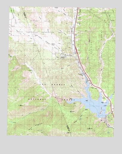
Black Mountain, CA USGS Topographic Map
Click on map above to begin viewing in our Map Viewer.

This topographic map contains these locations and features:
Feature Name Type Latitude Longitude GNIS ID View Map
Alamo Ranch (historical)LocaleN34.7205°W118.8354°1669811View Map
Apple CanyonValleyN34.6861°W118.7868°269563View Map
Bailey HomesteadLocaleN34.6492°W118.8026°269626View Map
Bailey TrailTrailN34.6486°W118.7884°269627View Map
Bear GulchValleyN34.7014°W118.8712°269739View Map
Beartrap CanyonValleyN34.6519°W118.7851°269762View Map
Beartrap Picnic AreaLocaleN34.6514°W118.7854°254485View Map
Beartrap SpringSpringN34.6422°W118.7914°269768View Map
Black MountainSummitN34.6542°W118.8615°269888View Map
Buck CreekStreamN34.6650°W118.8243°270049View Map
Buck Creek CampsiteLocaleN34.6375°W118.8687°270050View Map
Buck Creek Guard StationLocaleN34.6917°W118.8512°270051View Map
Buck Creek SpringSpringN34.6374°W118.8697°270052View Map
Buck Creek TrailTrailN34.6414°W118.8607°270053View Map
Caņada de los AlamosValleyN34.6975°W118.7945°270256View Map
Carlos CanyonValleyN34.6680°W118.7926°270300View Map
CaswellPopulated PlaceN34.7222°W118.7984°270347View Map
Chumash IslandIslandN34.6508°W118.7654°254530View Map
Coyote CanyonValleyN34.6950°W118.7934°270661View Map
Dome MountainSummitN34.6286°W118.8023°1660558View Map
Dry CreekStreamN34.7014°W118.8712°270926View Map
Emigrant LandingLocaleN34.6786°W118.7806°254479View Map
Emigrant Landing Picnic AreaLocaleN34.6780°W118.7873°275330View Map
Freeman CanyonValleyN34.7100°W118.8165°271216View Map
Glory HoleLocaleN34.6722°W118.7884°254480View Map
Gorman CreekStreamN34.6889°W118.7893°271371View Map
Gorman Creek SiphonCanalN34.7136°W118.7993°271372View Map
Governor Edmund G Brown West Branch California AqueductCanalN34.7180°W118.7990°274419View Map
Hardluck CampgroundLocaleN34.6878°W118.8465°271493View Map
Hungry ValleyValleyN34.7305°W118.8662°271689View Map
Hungry Valley SiphonCanalN34.7017°W118.7970°271690View Map
Kinsey Ranch (historical)LocaleN34.7144°W118.8254°271907View Map
Lane Ranch (historical)LocaleN34.7216°W118.8462°271977View Map
Liebre GulchValleyN34.6622°W118.7576°272028View Map
Liebre Gulch Maintenance Station (historical)LocaleN34.6555°W118.7637°1693367View Map
Liebre Pumping Station (historical)LocaleN34.6569°W118.7654°1666858View Map
Los Alamos CampgroundLocaleN34.7005°W118.8065°276621View Map
Los Alamos Recreation SiteLocaleN34.7014°W118.8051°275331View Map
Lost MineLocaleN34.6655°W118.7890°254481View Map
Lower Hungry ValleyValleyN34.7019°W118.8001°272259View Map
Mystic CanyonValleyN34.7230°W118.8037°254476View Map
Nugget PointCapeN34.6617°W118.7815°254483View Map
Peace ValleyValleyN34.7019°W118.7954°272901View Map
Peace Valley PipelineLocaleN34.7208°W118.7995°1654894View Map
Piru GorgeValleyN34.6353°W118.7534°273031View Map
Piru Guard Station (historical)LocaleN34.6933°W118.8529°1693379View Map
Posey CanyonValleyN34.6489°W118.7543°273088View Map
PriestLocaleN34.6753°W118.7868°254478View Map
Pyramid 1-066 DamDamN34.6450°W118.7643°1663267View Map
Pyramid LakeReservoirN34.6575°W118.7760°273141View Map
Pyramid RockSummitN34.6414°W118.7643°1661266View Map
Quail CanyonValleyN34.7358°W118.8006°254474View Map
Quail Canyon CampgroundLocaleN34.7497°W118.8198°254475View Map
Ridge Tavern (historical)BuildingN34.7119°W118.7976°1693368View Map
Royball SpringSpringN34.6295°W118.7586°248445View Map
Serrano Picnic AreaLocaleN34.6547°W118.7593°254529View Map
Side Hill SiphonCanalN34.6911°W118.7912°273699View Map
Slide MountainSummitN34.6330°W118.7776°254486View Map
Slide Mountain LookoutLocaleN34.6328°W118.7779°275410View Map
Smith ForkStreamN34.7022°W118.8673°273764View Map
Smith Fork Guard Station (historical)LocaleN34.7030°W118.8668°1693380View Map
Snowy CreekStreamN34.6939°W118.8615°273787View Map
Spanish PointCapeN34.6572°W118.7623°254528View Map
Tin Cup Picnic AreaLocaleN34.6569°W118.7987°254484View Map
Vaquero Picnic AreaLocaleN34.6630°W118.7651°254532View Map
West Fork Liebre GulchValleyN34.6555°W118.7631°274434View Map
White MountainSummitN34.6308°W118.8479°274471View Map
William E Warne Power PlantBuildingN34.6844°W118.7884°254477View Map
Yellow Bar Picnic AreaLocaleN34.6622°W118.7995°254482View Map

Note: Coordinates in the location and feature list above are referenced to NAD83 datum.


Copyright (C) 2008-2024 Ryan Niemi / Sunset Dynamics ... All Rights Reserved