TopoQuest Logo
Do you find TopoQuest useful?
Help keep TopoQuest running and adding new maps/features by donating!
Bitcoin:  19c7KJd3qBynnjoSw5npx9KScwjBe4ifkT
Litecoin:  LXs6TkuXGGXo1vDsWCkWVdjQX94eUKd6ui
Home View Maps Find Maps Find Places Resources & Links


Lecompte, Louisiana Topographic Map

USGS Map Title: Lecompte, LA
USGS Map MRC: 31092A4
DRG (GeoTIFF) Download: o31092a4.tif


Neighboring USGS Topographic Map Quads:


  Woodworth West, LA  
31092B5
 

  Woodworth East, LA  
31092B4
 

  Latanier, LA  
31092B3
 

  Forest Hill, LA  
31092A5
 

  Lecompte, LA  
31092A4
 

  Cheneyville, LA  
31092A3
 

  Glenmora, LA  
30092H5
 

  Cocodrie Lake, LA  
30092H4
 

  Lone Pine, LA  
30092H3


Map MRC Location:

N32°
W93°
N32°
W92°
H8 H7 H6 H5 H4 H3 H2 H1
G8 G7 G6 G5 G4 G3 G2 G1
F8 F7 F6 F5 F4 F3 F2 F1
E8 E7 E6 E5 E4 E3 E2 E1
D8 D7 D6 D5 D4 D3 D2 D1
C8 C7 C6 C5 C4 C3 C2 C1
B8 B7 B6 B5 B4 B3 B2 B1
A8 A7 A6 A5 A4 A3 A2 A1
N31°
W93°
N31°
W92°

Lecompte, LA USGS 1:24K Topographic Map Preview:
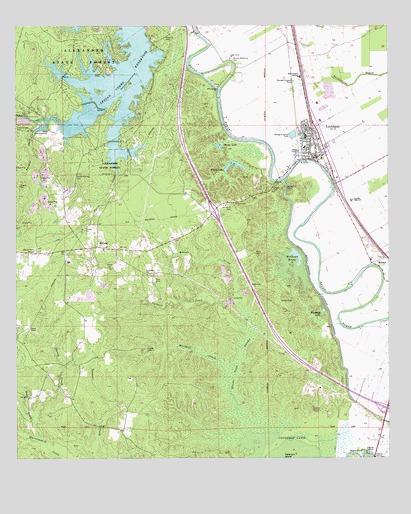
Lecompte, LA USGS Topographic Map
Click on map above to begin viewing in our Map Viewer.

This topographic map contains these locations and features:
Feature Name Type Latitude Longitude GNIS ID View Map
Alexander State ForestForestN31.1241°W92.4885°553278View Map
Ballard CemeteryCemeteryN31.0738°W92.4268°532293View Map
Bayou Cocodrie DamDamN31.0002°W92.3835°556707View Map
Beaver CreekStreamN31.0452°W92.4246°532857View Map
Beaver Creek SwampSwampN31.0062°W92.4256°553557View Map
Beechfish Fish HatcheryLocaleN31.0941°W92.4918°551670View Map
Burgess CreekStreamN31.0971°W92.4929°533554View Map
Carnal CemeteryCemeteryN31.0824°W92.4676°533770View Map
Carr CreekStreamN31.1235°W92.4396°551681View Map
Carrs CreekStreamN31.0824°W92.4662°533786View Map
Carter C Raymond Middle SchoolSchoolN31.0935°W92.4027°551682View Map
Cedar Grove ChurchChurchN31.1157°W92.4285°533839View Map
Cheney CreekStreamN31.0102°W92.4937°553964View Map
Cheneyville Ward ThreeCivilN31.0705°W92.3810°545170View Map
Chinquapin CreekStreamN31.1085°W92.4696°551687View Map
Cockrell CreekStreamN31.0385°W92.4246°554032View Map
Freeman LakeLakeN31.0432°W92.3970°554478View Map
Good Hope ChurchChurchN31.0532°W92.4562°535271View Map
Hardy LakeLakeN31.0904°W92.4318°554657View Map
Hawkins CemeteryCemeteryN31.1224°W92.4482°535565View Map
Hobson (historical)Populated PlaceN31.0305°W92.4487°551717View Map
Indian CreekStreamN31.0971°W92.4860°547508View Map
Indian Creek CemeteryCemeteryN31.0950°W92.5000°547509View Map
Indian Creek ReservoirReservoirN31.1024°W92.4710°554825View Map
Indian Creek ReservoirReservoirN31.0973°W92.4804°556717View Map
KALB-TV (Alexandria)TowerN31.0377°W92.4960°1633121View Map
KZMZ-FM (Alexandria)TowerN31.0377°W92.4960°1633030View Map
LecomptePopulated PlaceN31.0946°W92.4004°536385View Map
Lecompte CemeteryCemeteryN31.0721°W92.4271°536386View Map
Lecompte Police DepartmentBuildingN31.0873°W92.3976°2755268View Map
Lecompte Volunteer Fire Department Station 1BuildingN31.0865°W92.4002°2672942View Map
Linzay CemeteryCemeteryN31.0777°W92.4143°555045View Map
Living Tabernacle Church (historical)ChurchN31.0730°W92.4315°543868View Map
Marshall CreekStreamN31.0063°W92.4235°536911View Map
Martin Springs CemeteryCemeteryN31.0821°W92.4799°536921View Map
Mathews BrakeLakeN31.0569°W92.4055°555250View Map
Mathews CemeteryCemeteryN31.0627°W92.4140°551738View Map
MeekerPopulated PlaceN31.0566°W92.3807°543463View Map
Meeker CemeteryCemeteryN31.0455°W92.4073°537025View Map
MidwayPopulated PlaceN31.0613°W92.4726°537067View Map
Mount Lebanon Baptist ChurchChurchN31.1074°W92.4324°555393View Map
Paul CemeteryCemeteryN31.0516°W92.4540°555606View Map
Pisgah CemeteryCemeteryN31.0319°W92.4565°538218View Map
Pisgah Church (historical)ChurchN31.0321°W92.4565°551761View Map
Rapides High SchoolSchoolN31.0745°W92.3874°538495View Map
Red River Academy SchoolSchoolN31.0975°W92.3978°2462830View Map
Sartori (historical)Populated PlaceN31.0196°W92.3910°551780View Map
Smith Mill School (historical)SchoolN31.0105°W92.4690°551784View Map
Soap CreekStreamN31.0052°W92.4912°548005View Map
South Rapides AcademySchoolN31.1102°W92.4046°539511View Map
Spring Hill CemeteryCemeteryN31.0785°W92.4099°539593View Map
Town of LecompteCivilN31.0882°W92.3999°2405997View Map
Weems LakeLakeN31.0846°W92.4246°556380View Map
Wells CemeteryCemeteryN31.0594°W92.4199°540288View Map
Wilmer Memorial CemeteryCemeteryN31.1157°W92.4271°540476View Map

Note: Coordinates in the location and feature list above are referenced to NAD83 datum.


Copyright (C) 2008-2024 Ryan Niemi / Sunset Dynamics ... All Rights Reserved