TopoQuest Logo
Do you find TopoQuest useful?
Help keep TopoQuest running and adding new maps/features by donating!
Bitcoin:  19c7KJd3qBynnjoSw5npx9KScwjBe4ifkT
Litecoin:  LXs6TkuXGGXo1vDsWCkWVdjQX94eUKd6ui
Home View Maps Find Maps Find Places Resources & Links


Woodworth West, Louisiana Topographic Map

USGS Map Title: Woodworth West, LA
USGS Map MRC: 31092B5
DRG (GeoTIFF) Download: o31092b5.tif


Neighboring USGS Topographic Map Quads:


  Gardner, LA  
31092C6
 

  Rapides, LA  
31092C5
 

  Alexandria, LA  
31092C4
 

  Elmer, LA  
31092B6
 

  Woodworth West, LA  
31092B5
 

  Woodworth East, LA  
31092B4
 

  Melder, LA  
31092A6
 

  Forest Hill, LA  
31092A5
 

  Lecompte, LA  
31092A4


Map MRC Location:

N32°
W93°
N32°
W92°
H8 H7 H6 H5 H4 H3 H2 H1
G8 G7 G6 G5 G4 G3 G2 G1
F8 F7 F6 F5 F4 F3 F2 F1
E8 E7 E6 E5 E4 E3 E2 E1
D8 D7 D6 D5 D4 D3 D2 D1
C8 C7 C6 C5 C4 C3 C2 C1
B8 B7 B6 B5 B4 B3 B2 B1
A8 A7 A6 A5 A4 A3 A2 A1
N31°
W93°
N31°
W92°

Woodworth West, LA USGS 1:24K Topographic Map Preview:
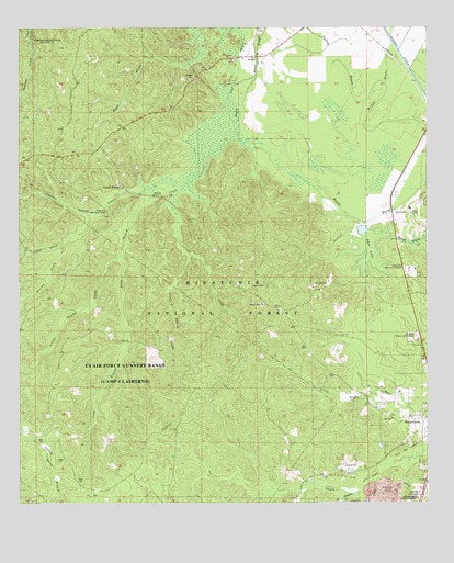
Woodworth West, LA USGS Topographic Map
Click on map above to begin viewing in our Map Viewer.

This topographic map contains these locations and features:
Feature Name Type Latitude Longitude GNIS ID View Map
Alexander Memorial GardensCemeteryN31.1866°W92.5054°546958View Map
Bayou Boeuf Natural Research AreaLocaleN31.2107°W92.5340°548224View Map
Bayou Clear School (historical)SchoolN31.1310°W92.5382°551667View Map
Bayou HospitalStreamN31.1288°W92.5212°547018View Map
Big Brushy CreekStreamN31.1938°W92.6113°547135View Map
Boggu BayouStreamN31.2466°W92.5696°547112View Map
Castor CreekStreamN31.2202°W92.5574°553919View Map
Castor Creek Scenic AreaParkN31.1924°W92.6132°548257View Map
Castor PlungePopulated PlaceN31.2085°W92.5940°547197View Map
Claiborne RangeMilitaryN31.1667°W92.6201°2512454View Map
Clear CreekStreamN31.1938°W92.6110°547226View Map
Cypress BranchStreamN31.2063°W92.5940°547278View Map
Evangeline CampLocaleN31.2321°W92.6104°548225View Map
Grassy BayouStreamN31.2496°W92.5524°547413View Map
Little Brushy CreekStreamN31.1905°W92.5940°547594View Map
Little CreekStreamN31.1907°W92.5729°547598View Map
Little Loving CreekStreamN31.1905°W92.5732°548255View Map
Long BranchStreamN31.2069°W92.5838°555135View Map
Lost BayouStreamN31.2255°W92.5588°547630View Map
Lost Bayou School (historical)SchoolN31.2402°W92.5499°551734View Map
Loving CreekStreamN31.2066°W92.5782°547633View Map
Magnolia Forest WalkTrailN31.1982°W92.5999°548256View Map
Magnolia Recreation ParkParkN31.2030°W92.5979°547643View Map
Middle BayouStreamN31.2402°W92.5521°547686View Map
Oden LakeLakeN31.1932°W92.5172°555536View Map
Rapides ParishCivilN31.1986°W92.5332°559460View Map
Saint Mark Church (historical)ChurchN31.1441°W92.6210°551775View Map
Sunrise Memorial GardensCemeteryN31.1688°W92.5032°548055View Map
Town of WoodworthCivilN31.1653°W92.5099°2406916View Map
Twin BridgesBridgeN31.2427°W92.5524°548100View Map
Twin Bridges Church (historical)ChurchN31.2474°W92.5426°551794View Map
Wild Azalea TrailTrailN31.2132°W92.6157°548207View Map
Woodworth AirportAirportN31.1262°W92.5003°557038View Map
Woodworth Lookout Tower (historical)LocaleN31.1821°W92.5588°551807View Map
Woodworth Volunteer Fire DepartmentBuildingN31.1749°W92.5035°2672938View Map

Note: Coordinates in the location and feature list above are referenced to NAD83 datum.


Copyright (C) 2008-2025 Ryan Niemi / Sunset Dynamics ... All Rights Reserved