TopoQuest Logo
Do you find TopoQuest useful?
Help keep TopoQuest running and adding new maps/features by donating!
Bitcoin:  19c7KJd3qBynnjoSw5npx9KScwjBe4ifkT
Litecoin:  LXs6TkuXGGXo1vDsWCkWVdjQX94eUKd6ui
Home View Maps Find Maps Find Places Resources & Links


Cheneyville, Louisiana Topographic Map

USGS Map Title: Cheneyville, LA
USGS Map MRC: 31092A3
DRG (GeoTIFF) Download: o31092a3.tif


Neighboring USGS Topographic Map Quads:


  Woodworth East, LA  
31092B4
 

  Latanier, LA  
31092B3
 

  Effie, LA  
31092B2
 

  Lecompte, LA  
31092A4
 

  Cheneyville, LA  
31092A3
 

  Belle d'Eau, LA  
31092A2
 

  Cocodrie Lake, LA  
30092H4
 

  Lone Pine, LA  
30092H3
 

  Bunkie, LA  
30092H2


Map MRC Location:

N32°
W93°
N32°
W92°
H8 H7 H6 H5 H4 H3 H2 H1
G8 G7 G6 G5 G4 G3 G2 G1
F8 F7 F6 F5 F4 F3 F2 F1
E8 E7 E6 E5 E4 E3 E2 E1
D8 D7 D6 D5 D4 D3 D2 D1
C8 C7 C6 C5 C4 C3 C2 C1
B8 B7 B6 B5 B4 B3 B2 B1
A8 A7 A6 A5 A4 A3 A2 A1
N31°
W93°
N31°
W92°

Cheneyville, LA USGS 1:24K Topographic Map Preview:
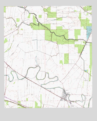
Cheneyville, LA USGS Topographic Map
Click on map above to begin viewing in our Map Viewer.

This topographic map contains these locations and features:
Feature Name Type Latitude Longitude GNIS ID View Map
Bayou CurrentStreamN31.1230°W92.2787°532552View Map
Bayou De ScottStreamN31.1196°W92.3410°551872View Map
Bayou PompeyStreamN31.1010°W92.3260°553511View Map
Bayou RougeStreamN31.0894°W92.2899°532759View Map
Bayou SansLakeN31.0596°W92.3297°553519View Map
Beulah Baptist ChurchChurchN31.0124°W92.2897°2601398View Map
Bird Pond (historical)LakeN31.0127°W92.3399°551819View Map
Calahan BayouStreamN31.0999°W92.3537°533614View Map
Cappel BayouStreamN31.1052°W92.3262°533762View Map
CheneyvillePopulated PlaceN31.0149°W92.2874°533897View Map
Cheneyville Landing StripAirportN31.0010°W92.2807°543819View Map
Cheneyville Post OfficePost OfficeN31.0114°W92.2895°1631716View Map
Cheneyville Volunteer Fire DepartmentBuildingN31.0110°W92.2867°2673095View Map
Christians CemeteryCemeteryN31.0216°W92.2882°543820View Map
Cowhead BayouGutN31.0721°W92.3585°554109View Map
Cross BayouGutN31.1141°W92.3501°551829View Map
Edgefield Baptist ChurchChurchN31.0219°W92.2912°2601587View Map
First Christian ChurchChurchN31.0134°W92.2886°2601790View Map
Fish LakeLakeN31.0763°W92.2854°551838View Map
KRBG-FM (Bunkie)TowerN31.0874°W92.3596°1632433View Map
LoydPopulated PlaceN31.0446°W92.3585°551851View Map
Lyles (historical)Populated PlaceN31.0374°W92.3446°551852View Map
Morgan BayouGutN31.0146°W92.3471°551854View Map
New Hope PlantationLocaleN31.0527°W92.3271°551857View Map
Rattlesnake BayouStreamN31.1002°W92.3537°538502View Map
RoxanaPopulated PlaceN31.1188°W92.2587°543631View Map
Saint Samuel ChurchChurchN31.0516°W92.3290°539073View Map
Second Edgefield Baptist ChurchChurchN31.0167°W92.2812°2602785View Map
Stafford CemeteryCemeteryN31.0241°W92.3040°539614View Map
Town of CheneyvilleCivilN31.0110°W92.2901°2406260View Map
Union ChapelChurchN31.0371°W92.3435°540085View Map
Vaughan Landing StripAirportN31.0305°W92.3421°557068View Map
Wilson LakeLakeN31.1247°W92.2538°556455View Map
Witchwood (historical)Populated PlaceN31.0260°W92.3224°551883View Map
Wytchwood PlantationLocaleN31.0285°W92.3229°551884View Map

Note: Coordinates in the location and feature list above are referenced to NAD83 datum.


Copyright (C) 2008-2024 Ryan Niemi / Sunset Dynamics ... All Rights Reserved