TopoQuest Logo
Do you find TopoQuest useful?
Help keep TopoQuest running and adding new maps/features by donating!
Bitcoin:  19c7KJd3qBynnjoSw5npx9KScwjBe4ifkT
Litecoin:  LXs6TkuXGGXo1vDsWCkWVdjQX94eUKd6ui
Home View Maps Find Maps Find Places Resources & Links


Leming, Texas Topographic Map

USGS Map Title: Leming, TX
USGS Map MRC: 29098A4
DRG (GeoTIFF) Download: o29098a4.tif


Neighboring USGS Topographic Map Quads:


  Thelma, TX  
29098B5
 

  Losoya, TX  
29098B4
 

  Saspamco, TX  
29098B3
 

  Poteet, TX  
29098A5
 

  Leming, TX  
29098A4
 

  Saspamco SE, TX  
29098A3
 

  Jourdanton, TX  
28098H5
 

  Pleasanton, TX  
28098H4
 

  Leal, TX  
28098H3


Map MRC Location:

N30°
W99°
N30°
W98°
H8 H7 H6 H5 H4 H3 H2 H1
G8 G7 G6 G5 G4 G3 G2 G1
F8 F7 F6 F5 F4 F3 F2 F1
E8 E7 E6 E5 E4 E3 E2 E1
D8 D7 D6 D5 D4 D3 D2 D1
C8 C7 C6 C5 C4 C3 C2 C1
B8 B7 B6 B5 B4 B3 B2 B1
A8 A7 A6 A5 A4 A3 A2 A1
N29°
W99°
N29°
W98°

Leming, TX USGS 1:24K Topographic Map Preview:
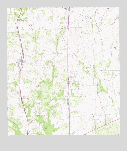
Leming, TX USGS Topographic Map
Click on map above to begin viewing in our Map Viewer.

This topographic map contains these locations and features:
Feature Name Type Latitude Longitude GNIS ID View Map
Brite CemeteryCemeteryN29.0575°W98.4453°1352904View Map
EspeyPopulated PlaceN29.1125°W98.4889°2034623View Map
Gallinas CreekStreamN29.0202°W98.4683°1357835View Map
Korus FarmsteadLocaleN29.1094°W98.4856°2032073View Map
Las GallinasPopulated PlaceN29.1125°W98.4886°1380061View Map
LemingPopulated PlaceN29.0730°W98.4842°1361075View Map
Leming Census Designated PlaceCensusN29.0683°W98.4722°2586951View Map
Leming Post OfficePost OfficeN29.0676°W98.4855°2731468View Map
LoirePopulated PlaceN29.1100°W98.3956°1380101View Map
Longs Farm Airport (historical)AirportN29.0994°W98.4658°1387070View Map
Positeus CreekStreamN29.0739°W98.4467°1365621View Map
Purtle HollowValleyN29.0885°W98.4448°1365873View Map
Rodriguez CemeteryCemeteryN29.0172°W98.4731°1366819View Map
Saint Joseph CemeteryCemeteryN29.1119°W98.4872°1367193View Map
Saint Joseph ChurchChurchN29.1130°W98.4786°1367201View Map
Saint Luke CemeteryCemeteryN29.1152°W98.3967°1367223View Map
Ten Oaks Airport (historical)AirportN29.1002°W98.4489°1387071View Map
Tuminson CemeteryCemeteryN29.0800°W98.4483°1370206View Map
VerdiPopulated PlaceN29.0500°W98.3995°1380716View Map
West Lucas CreekStreamN29.1002°W98.4045°1371179View Map

Note: Coordinates in the location and feature list above are referenced to NAD83 datum.


Copyright (C) 2008-2025 Ryan Niemi / Sunset Dynamics ... All Rights Reserved