TopoQuest Logo
Do you find TopoQuest useful?
Help keep TopoQuest running and adding new maps/features by donating!
Bitcoin:  19c7KJd3qBynnjoSw5npx9KScwjBe4ifkT
Litecoin:  LXs6TkuXGGXo1vDsWCkWVdjQX94eUKd6ui
Home View Maps Find Maps Find Places Resources & Links


Pleasanton, Texas Topographic Map

USGS Map Title: Pleasanton, TX
USGS Map MRC: 28098H4
DRG (GeoTIFF) Download: o28098h4.tif


Neighboring USGS Topographic Map Quads:


  Poteet, TX  
29098A5
 

  Leming, TX  
29098A4
 

  Saspamco SE, TX  
29098A3
 

  Jourdanton, TX  
28098H5
 

  Pleasanton, TX  
28098H4
 

  Leal, TX  
28098H3
 

  Christine West, TX  
28098G5
 

  Christine East, TX  
28098G4
 

  McCoy, TX  
28098G3


Map MRC Location:

N29°
W99°
N29°
W98°
H8 H7 H6 H5 H4 H3 H2 H1
G8 G7 G6 G5 G4 G3 G2 G1
F8 F7 F6 F5 F4 F3 F2 F1
E8 E7 E6 E5 E4 E3 E2 E1
D8 D7 D6 D5 D4 D3 D2 D1
C8 C7 C6 C5 C4 C3 C2 C1
B8 B7 B6 B5 B4 B3 B2 B1
A8 A7 A6 A5 A4 A3 A2 A1
N28°
W99°
N28°
W98°

Pleasanton, TX USGS 1:24K Topographic Map Preview:
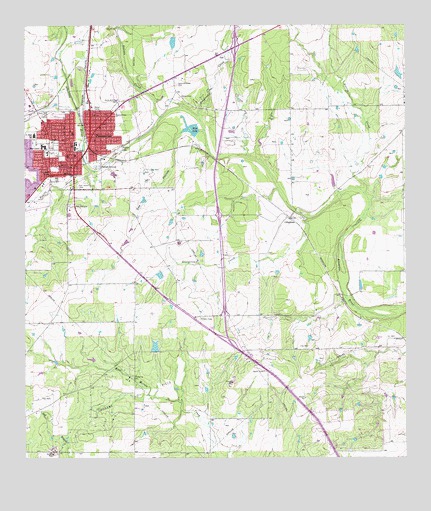
Pleasanton, TX USGS Topographic Map
Click on map above to begin viewing in our Map Viewer.

This topographic map contains these locations and features:
Feature Name Type Latitude Longitude GNIS ID View Map
Atascosa City ParkParkN28.9733°W98.4825°2028848View Map
Atascosa County Emergency Medical ServicesBuildingN28.9599°W98.4855°2655930View Map
Atascosa Cowboy Recreation CenterParkN28.9844°W98.4825°2028849View Map
Atascosa First Seventh Day Adventist ChurchChurchN28.9719°W98.4739°2016521View Map
Atascosa River ParkParkN28.9594°W98.4783°2028850View Map
Averia CreekStreamN28.9516°W98.3889°1351350View Map
Bonita CreekStreamN28.9580°W98.4781°1352660View Map
Church of ChristChurchN28.9686°W98.4847°2016517View Map
City of PleasantonCivilN28.9644°W98.4949°2411442View Map
City ParkParkN28.9736°W98.4828°2028604View Map
Community Bible Chapel ChurchChurchN28.9522°W98.4975°2016522View Map
CoughranPopulated PlaceN28.9444°W98.4136°1379602View Map
Fairview Farms DamDamN28.9852°W98.3786°1860508View Map
Fairview LakeReservoirN28.9866°W98.3775°1860509View Map
First Presbyterian ChurchChurchN28.9666°W98.4925°2016520View Map
Galvan CreekStreamN28.9736°W98.4550°1357840View Map
Georgetown CreekStreamN28.9444°W98.4075°1357962View Map
Imogene Oil FieldOilfieldN28.8978°W98.4553°1359896View Map
Lyons ParkParkN28.9747°W98.4953°2029854View Map
Oak HollowValleyN28.9696°W98.4483°1364291View Map
PleasantonPopulated PlaceN28.9672°W98.4786°1375500View Map
Pleasanton City HallBuildingN28.9596°W98.4834°2753884View Map
Pleasanton DivisionCivilN28.9922°W98.4153°1939095View Map
Pleasanton Elementary SchoolSchoolN28.9644°W98.4845°2003017View Map
Pleasanton Fire DepartmentBuildingN28.9575°W98.4901°2551971View Map
Pleasanton High SchoolSchoolN28.9661°W98.4681°2003018View Map
Pleasanton Intermediate SchoolSchoolN28.9677°W98.4967°2003019View Map
Pleasanton Police DepartmentBuildingN28.9577°W98.4915°2750329View Map
Pleasanton Post OfficePost OfficeN28.9593°W98.4850°2732026View Map
Presleano CreekStreamN28.9725°W98.4422°1365759View Map
Primera Iglesia Bautista ChurchChurchN28.9669°W98.4767°2016578View Map
Quality Ambulance ServiceBuildingN28.9649°W98.4800°2655929View Map
Quillian DamDamN28.9053°W98.4570°1860510View Map
Quillian LakeReservoirN28.9067°W98.4576°1860511View Map
Rips LakeReservoirN28.9702°W98.4431°1366500View Map
Rips Lake DamDamN28.9702°W98.4436°1860504View Map
Saint Andrew Catholic ChurchChurchN28.9711°W98.4736°2016579View Map
Saint Andrews CemeteryCemeteryN28.9786°W98.4692°1367125View Map
Saint Andrews CemeteryCemeteryN28.9833°W98.4506°1367126View Map
San Pedro Branch LibraryBuildingN28.8830°W98.4997°2014761View Map
San Ysidro CemeteryCemeteryN28.9539°W98.4831°1367544View Map
Sotelo CemeteryCemeteryN28.9794°W98.4492°1368613View Map
Texas Regional Emergency Medical ServicesBuildingN28.9743°W98.4791°2655928View Map
Thousand Oaks LibraryBuildingN28.8953°W98.4020°2014736View Map
Williams DamDamN28.9286°W98.4553°1860506View Map
Williams LakeReservoirN28.9280°W98.4563°1860507View Map

Note: Coordinates in the location and feature list above are referenced to NAD83 datum.


Copyright (C) 2008-2025 Ryan Niemi / Sunset Dynamics ... All Rights Reserved