TopoQuest Logo
Do you find TopoQuest useful?
Help keep TopoQuest running and adding new maps/features by donating!
Bitcoin:  19c7KJd3qBynnjoSw5npx9KScwjBe4ifkT
Litecoin:  LXs6TkuXGGXo1vDsWCkWVdjQX94eUKd6ui
Home View Maps Find Maps Find Places Resources & Links


Leola, Arkansas Topographic Map

USGS Map Title: Leola, AR
USGS Map MRC: 34092B5
DRG (GeoTIFF) Download: o34092b5.tif


Neighboring USGS Topographic Map Quads:


  Poyen, AR  
34092C6
 

  Prattsville, AR  
34092C5
 

  Sheridan, AR  
34092C4
 

  Willow, AR  
34092B6
 

  Leola, AR  
34092B5
 

  Millerville, AR  
34092B4
 

  Tulip, AR  
34092A6
 

  Carthage, AR  
34092A5
 

  Bunn, AR  
34092A4


Map MRC Location:

N35°
W93°
N35°
W92°
H8 H7 H6 H5 H4 H3 H2 H1
G8 G7 G6 G5 G4 G3 G2 G1
F8 F7 F6 F5 F4 F3 F2 F1
E8 E7 E6 E5 E4 E3 E2 E1
D8 D7 D6 D5 D4 D3 D2 D1
C8 C7 C6 C5 C4 C3 C2 C1
B8 B7 B6 B5 B4 B3 B2 B1
A8 A7 A6 A5 A4 A3 A2 A1
N34°
W93°
N34°
W92°

Leola, AR USGS 1:24K Topographic Map Preview:
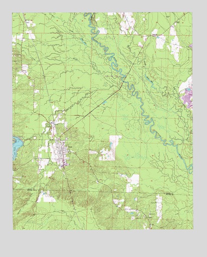
Leola, AR USGS Topographic Map
Click on map above to begin viewing in our Map Viewer.

This topographic map contains these locations and features:
Feature Name Type Latitude Longitude GNIS ID View Map
Brush CreekStreamN34.2118°W92.5496°47041View Map
CarverPopulated PlaceN34.2165°W92.6185°76539View Map
CooneyPopulated PlaceN34.1323°W92.5318°56968View Map
Cox CreekStreamN34.2029°W92.5424°76698View Map
Cox Creek LakeReservoirN34.1711°W92.6247°74767View Map
Cox Creek Lake DamDamN34.1787°W92.6224°80250View Map
Crowder CemeteryCemeteryN34.1318°W92.5404°48230View Map
DogwoodPopulated PlaceN34.2368°W92.5265°56992View Map
Guesses CreekStreamN34.1859°W92.6002°77082View Map
Herbert CreekStreamN34.2451°W92.5710°50025View Map
Hopewell ChurchChurchN34.1337°W92.5304°50307View Map
IvyPopulated PlaceN34.1282°W92.5296°57068View Map
Jenkins Ferry State ParkParkN34.2132°W92.5474°60630View Map
Katheryn's Landing Airport (historical)AirportN34.1645°W92.6013°83746View Map
LeolaPopulated PlaceN34.1695°W92.5910°58056View Map
Leola Volunteer Fire DepartmentBuildingN34.1698°W92.5909°2116706View Map
Moores CemeteryCemeteryN34.2476°W92.5182°52173View Map
Moores ChapelChurchN34.2443°W92.5115°52174View Map
Moores LakeLakeN34.2105°W92.5294°75033View Map
Moores SloughStreamN34.2029°W92.5129°52178View Map
Mud CreekStreamN34.2262°W92.5607°52515View Map
Taylor CemeteryCemeteryN34.1845°W92.5974°55462View Map
ThielPopulated PlaceN34.2454°W92.6160°57205View Map
Tolar LakeLakeN34.2332°W92.5757°75173View Map
Town of LeolaCivilN34.1701°W92.5914°2406005View Map
Township of DavisCivilN34.2477°W92.5080°66605View Map
Township of TennesseeCivilN34.2065°W92.6073°66613View Map

Note: Coordinates in the location and feature list above are referenced to NAD83 datum.


Copyright (C) 2008-2024 Ryan Niemi / Sunset Dynamics ... All Rights Reserved