TopoQuest Logo
Do you find TopoQuest useful?
Help keep TopoQuest running and adding new maps/features by donating!
Bitcoin:  19c7KJd3qBynnjoSw5npx9KScwjBe4ifkT
Litecoin:  LXs6TkuXGGXo1vDsWCkWVdjQX94eUKd6ui
Home View Maps Find Maps Find Places Resources & Links


Leslie, Missouri Topographic Map

USGS Map Title: Leslie, MO
USGS Map MRC: 38091D2
DRG (GeoTIFF) Download: o38091d2.tif


Neighboring USGS Topographic Map Quads:


  Dissen, MO  
38091E3
 

  New Haven, MO  
38091E2
 

  Washington West, MO  
38091E1
 

  Gerald, MO  
38091D3
 

  Leslie, MO  
38091D2
 

  Union, MO  
38091D1
 

  Strain, MO  
38091C3
 

  Spring Bluff, MO  
38091C2
 

  Stanton, MO  
38091C1


Map MRC Location:

N39°
W92°
N39°
W91°
H8 H7 H6 H5 H4 H3 H2 H1
G8 G7 G6 G5 G4 G3 G2 G1
F8 F7 F6 F5 F4 F3 F2 F1
E8 E7 E6 E5 E4 E3 E2 E1
D8 D7 D6 D5 D4 D3 D2 D1
C8 C7 C6 C5 C4 C3 C2 C1
B8 B7 B6 B5 B4 B3 B2 B1
A8 A7 A6 A5 A4 A3 A2 A1
N38°
W92°
N38°
W91°

Leslie, MO USGS 1:24K Topographic Map Preview:
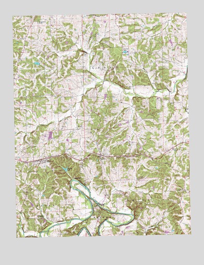
Leslie, MO USGS Topographic Map
Click on map above to begin viewing in our Map Viewer.

This topographic map contains these locations and features:
Feature Name Type Latitude Longitude GNIS ID View Map
Adams SchoolSchoolN38.4470°W91.1676°755531View Map
Anglers Lake DamDamN38.3767°W91.1435°764645View Map
BeaufortPopulated PlaceN38.4209°W91.1890°731528View Map
Beaufort - Leslie Fire Protection District Station 1BuildingN38.4231°W91.1891°2620794View Map
Beaufort - Leslie Fire Protection District Station 2BuildingN38.4185°W91.2307°2621383View Map
Beaufort Lookout TowerTowerN38.3998°W91.1299°754998View Map
Beaufort Post OfficePost OfficeN38.4170°W91.1893°2783142View Map
Butler CemeteryCemeteryN38.4534°W91.1801°715122View Map
CascoLocaleN38.4703°W91.1690°735960View Map
Casco ChurchChurchN38.4876°W91.1918°715466View Map
Clover Bottom Fish Farm Lake DamDamN38.4851°W91.1368°765482View Map
Crazy Fox Farm Lake DamDamN38.4017°W91.1518°762082View Map
Dierking BranchStreamN38.4559°W91.1460°716892View Map
Findley FieldAirportN38.4077°W91.1570°758581View Map
Flamingo LakesReservoirN38.4784°W91.1671°717981View Map
Fox CreekStreamN38.3932°W91.1909°718141View Map
GreenstreetPopulated PlaceN38.4064°W91.2032°718828View Map
Holy Family SchoolSchoolN38.4959°W91.2310°735653View Map
Janssen Lake DamDamN38.4384°W91.1735°762083View Map
LesliePopulated PlaceN38.4178°W91.2321°720921View Map
Leslie Post OfficePost OfficeN38.4183°W91.2314°2779471View Map
Leslie United Methodist CemeteryCemeteryN38.4213°W91.2237°2702126View Map
Liberty SchoolSchoolN38.4895°W91.1732°747983View Map
Little CreekStreamN38.3834°W91.2135°721205View Map
Little Creek Ford (historical)LocaleN38.3820°W91.2149°755657View Map
Little Creek SchoolSchoolN38.3862°W91.2318°747982View Map
Little Creek SpringSpringN38.3870°W91.2303°721214View Map
Lucky Nugget Lake DamDamN38.4351°W91.2235°764361View Map
McGinnis Lake DamDamN38.4551°W91.1835°762084View Map
Mineral LakeReservoirN38.4132°W91.2143°722428View Map
Mineral Lake DamDamN38.4123°W91.2135°763707View Map
Netties Greenhouse Lake DamDamN38.4734°W91.2318°764362View Map
Noser MillPopulated PlaceN38.3931°W91.1924°735754View Map
Noser Mill (historical)LocaleN38.3928°W91.1915°730593View Map
Old Beaufort SchoolSchoolN38.4384°W91.2252°747981View Map
Pleasant Hill SchoolSchoolN38.4845°W91.2185°747980View Map
Port Hudson ChurchChurchN38.4995°W91.1921°731635View Map
Port Hudson Holy Family ChurchChurchN38.4956°W91.2304°736373View Map
Port Hudson Lutheran SchoolSchoolN38.4995°W91.1918°747979View Map
Saint Johns ChurchChurchN38.4376°W91.2021°735827View Map
Saint Johns ChurchChurchN38.4839°W91.1840°735829View Map
School Number 11SchoolN38.4234°W91.1371°755392View Map
Sipe Lake DamDamN38.3850°W91.2301°764539View Map
South Beaufort SchoolSchoolN38.3981°W91.1729°747984View Map
Sunnys FieldAirportN38.4270°W91.2448°2770277View Map
Township of LyonCivilN38.4878°W91.2459°766648View Map
Village of LeslieCivilN38.4179°W91.2310°2398426View Map
Woodman CemeteryCemeteryN38.4121°W91.2355°729115View Map
Zion ChurchChurchN38.4209°W91.2238°729245View Map

Note: Coordinates in the location and feature list above are referenced to NAD83 datum.


Copyright (C) 2008-2025 Ryan Niemi / Sunset Dynamics ... All Rights Reserved