TopoQuest Logo
Do you find TopoQuest useful?
Help keep TopoQuest running and adding new maps/features by donating!
Bitcoin:  19c7KJd3qBynnjoSw5npx9KScwjBe4ifkT
Litecoin:  LXs6TkuXGGXo1vDsWCkWVdjQX94eUKd6ui
Home View Maps Find Maps Find Places Resources & Links


New Haven, Missouri Topographic Map

USGS Map Title: New Haven, MO
USGS Map MRC: 38091E2
DRG (GeoTIFF) Download: o38091e2.tif


Neighboring USGS Topographic Map Quads:


  Berger, MO  
38091F3
 

  Treloar, MO  
38091F2
 

  Marthasville, MO  
38091F1
 

  Dissen, MO  
38091E3
 

  New Haven, MO  
38091E2
 

  Washington West, MO  
38091E1
 

  Gerald, MO  
38091D3
 

  Leslie, MO  
38091D2
 

  Union, MO  
38091D1


Map MRC Location:

N39°
W92°
N39°
W91°
H8 H7 H6 H5 H4 H3 H2 H1
G8 G7 G6 G5 G4 G3 G2 G1
F8 F7 F6 F5 F4 F3 F2 F1
E8 E7 E6 E5 E4 E3 E2 E1
D8 D7 D6 D5 D4 D3 D2 D1
C8 C7 C6 C5 C4 C3 C2 C1
B8 B7 B6 B5 B4 B3 B2 B1
A8 A7 A6 A5 A4 A3 A2 A1
N38°
W92°
N38°
W91°

New Haven, MO USGS 1:24K Topographic Map Preview:
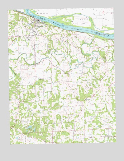
New Haven, MO USGS Topographic Map
Click on map above to begin viewing in our Map Viewer.

This topographic map contains these locations and features:
Feature Name Type Latitude Longitude GNIS ID View Map
Air Port Hudson AirportAirportN38.5061°W91.2493°2679409View Map
Alder CemeteryCemeteryN38.5606°W91.2129°713193View Map
Assumption CemeteryCemeteryN38.6048°W91.2418°713460View Map
Baltimore School (historical)SchoolN38.6120°W91.2443°730569View Map
Baltimore SettlementPopulated PlaceN38.6098°W91.2418°730571View Map
Bethlehem Lutheran ChurchChurchN38.5481°W91.2432°731535View Map
Bethlehem Lutheran Church CemeteryCemeteryN38.5484°W91.2435°2702117View Map
Big Berger CreekStreamN38.6209°W91.2290°729441View Map
Boeuf CreekStreamN38.6000°W91.1485°731536View Map
Boeuf IslandAreaN38.6170°W91.1426°731537View Map
Boeuf Island School (historical)SchoolN38.6139°W91.1451°730392View Map
Bucklick CreekStreamN38.5825°W91.2007°731542View Map
Bucklick SchoolSchoolN38.5506°W91.1763°747959View Map
CampbelltonPopulated PlaceN38.5401°W91.1607°736287View Map
Campbellton SchoolSchoolN38.5514°W91.1438°715315View Map
Cedar CemeteryCemeteryN38.5734°W91.2363°715576View Map
City of New HavenCivilN38.6048°W91.2179°2395200View Map
Deppermann Lake DamDamN38.5101°W91.1802°765486View Map
Enoch KnobSummitN38.5789°W91.1365°717603View Map
Gerding School (historical)SchoolN38.5725°W91.2357°747956View Map
Goose IslandIslandN38.6098°W91.1615°718593View Map
Kasel CemeteryCemeteryN38.5648°W91.1511°720478View Map
Kent (historical)LocaleN38.5984°W91.1510°740106View Map
KielPopulated PlaceN38.5217°W91.2438°740984View Map
Little Boeuf CreekStreamN38.5923°W91.1251°721160View Map
Luecker Lake DamDamN38.5234°W91.1535°765484View Map
LyonPopulated PlaceN38.5117°W91.1740°721701View Map
Maupin SchoolSchoolN38.5392°W91.2379°747957View Map
Miller School (historical)SchoolN38.5937°W91.2188°730570View Map
Mount Calvary CemeteryCemeteryN38.5062°W91.1337°722717View Map
Mud CreekStreamN38.5603°W91.2013°723011View Map
Nauser CemeteryCemeteryN38.5617°W91.2015°723132View Map
New HavenPopulated PlaceN38.6084°W91.2190°731625View Map
New Haven Berger Fire ProtectionBuildingN38.6016°W91.2142°2621724View Map
New Haven CemeteryCemeteryN38.5924°W91.2202°723215View Map
New Haven Police DepartmentBuildingN38.6150°W91.2152°2752526View Map
Newton Lake DamDamN38.5151°W91.1468°765485View Map
Nortmann CemeteryCemeteryN38.6114°W91.2463°723519View Map
Pin Oak CreekStreamN38.5839°W91.2332°735779View Map
Robert Stallman LakeReservoirN38.5057°W91.2418°763632View Map
Saint Peter CemeteryCemeteryN38.6087°W91.2285°725886View Map
Schall CemeteryCemeteryN38.5538°W91.1523°726092View Map
Schepp Lake DamDamN38.5117°W91.1785°765487View Map
Stallman Lake DamDamN38.5067°W91.2418°763631View Map
Struebbes DamDamN38.5750°W91.1668°764615View Map
Struebbes LakeReservoirN38.5759°W91.1681°764616View Map
Township of New HavenCivilN38.6048°W91.2179°766650View Map
Trinity CemeteryCemeteryN38.6004°W91.2383°727779View Map
United School (historical)SchoolN38.5198°W91.1627°747960View Map
Viedt CemeteryCemeteryN38.5614°W91.1511°728200View Map
Whispering Valley LakeReservoirN38.5157°W91.2265°764372View Map
Whispering Valley Lake Number 1 DamDamN38.5167°W91.2252°764371View Map
Whispering Valley Lake Number 2 DamDamN38.5151°W91.2202°764360View Map
Whispering Valley Lake Number 3 DamDamN38.5134°W91.2302°765222View Map
Wildcat CreekStreamN38.5803°W91.2290°728831View Map
Yates School (historical)SchoolN38.5896°W91.1719°747958View Map
Yeager LandingLocaleN38.6167°W91.2002°736193View Map

Note: Coordinates in the location and feature list above are referenced to NAD83 datum.


Copyright (C) 2008-2024 Ryan Niemi / Sunset Dynamics ... All Rights Reserved