TopoQuest Logo
Do you find TopoQuest useful?
Help keep TopoQuest running and adding new maps/features by donating!
Bitcoin:  19c7KJd3qBynnjoSw5npx9KScwjBe4ifkT
Litecoin:  LXs6TkuXGGXo1vDsWCkWVdjQX94eUKd6ui
Home View Maps Find Maps Find Places Resources & Links


Leslie, Georgia Topographic Map

USGS Map Title: Leslie, GA
USGS Map MRC: 31084H1
DRG (GeoTIFF) Download: o31084h1.tif


Neighboring USGS Topographic Map Quads:


  Americus, GA  
32084A2
 

  Methvins, GA  
32084A1
 

  Drayton, GA  
32083A8
 

  Smithville East, GA  
31084H2
 

  Leslie, GA  
31084H1
 

  Cobb, GA  
31083H8
 

  Neyami, GA  
31084G2
 

  Leslie SE, GA  
31084G1
 

  Warwick, GA  
31083G8


Map MRC Location:

N32°
W85°
N32°
W84°
H8 H7 H6 H5 H4 H3 H2 H1
G8 G7 G6 G5 G4 G3 G2 G1
F8 F7 F6 F5 F4 F3 F2 F1
E8 E7 E6 E5 E4 E3 E2 E1
D8 D7 D6 D5 D4 D3 D2 D1
C8 C7 C6 C5 C4 C3 C2 C1
B8 B7 B6 B5 B4 B3 B2 B1
A8 A7 A6 A5 A4 A3 A2 A1
N31°
W85°
N31°
W84°

Leslie, GA USGS 1:24K Topographic Map Preview:
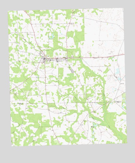
Leslie, GA USGS Topographic Map
Click on map above to begin viewing in our Map Viewer.

This topographic map contains these locations and features:
Feature Name Type Latitude Longitude GNIS ID View Map
Antioch ChurchChurchN31.8974°W84.0460°310568View Map
Carlan Airport (historical)AirportN31.9702°W84.0649°343425View Map
ChokeePopulated PlaceN31.8938°W84.0496°331397View Map
City of De SotoCivilN31.9548°W84.0636°2404203View Map
City of LeslieCivilN31.9545°W84.0864°2404915View Map
Davis Grove ChurchChurchN31.9868°W84.0574°313351View Map
Davis Grove School (historical)SchoolN31.9871°W84.0574°334912View Map
De Soto Lookout TowerTowerN31.9871°W84.0580°334913View Map
DeSotoPopulated PlaceN31.9554°W84.0621°355464View Map
DeSoto CemeteryCemeteryN31.9529°W84.0599°343434View Map
DeSoto Methodist ChurchChurchN31.9529°W84.0616°343435View Map
Desoto Volunteer Fire Department Station 5BuildingN31.9545°W84.0642°2604434View Map
Dry Branch CreekStreamN31.8927°W84.0202°313637View Map
Howell School (historical)SchoolN31.9868°W84.0996°343453View Map
Jackson Grove ChurchChurchN31.9302°W84.0055°316014View Map
Jones Store (historical)LocaleN31.8946°W84.1127°343388View Map
Kaylor LakeReservoirN31.8918°W84.0599°337664View Map
Kaylor Lake DamDamN31.8918°W84.0599°337663View Map
LesliePopulated PlaceN31.9554°W84.0866°316768View Map
Leslie City CemeteryCemeteryN31.9516°W84.0818°343459View Map
Leslie Fire DepartmentBuildingN31.9555°W84.0869°2603850View Map
Leslie Police DepartmentBuildingN31.9553°W84.0869°2733734View Map
Leslie Post OfficePost OfficeN31.9549°W84.0863°352149View Map
Leslie-De Soto DivisionCivilN31.9684°W84.0606°1936358View Map
Marthanna Grove ChurchChurchN31.9099°W84.1080°317731View Map
Mount Zion CemeteryCemeteryN31.9235°W84.1193°318922View Map
Mount Zion Church (historical)ChurchN31.9232°W84.1193°334914View Map
New Hope Church (historical)ChurchN31.8974°W84.1185°343395View Map
Parkers (historical)Populated PlaceN31.9768°W84.1127°343477View Map
Perry Grove ChurchChurchN31.9779°W84.1038°320393View Map
Piney Grove ChurchChurchN31.8793°W84.1013°320705View Map
Sadlers MillpondReservoirN31.8925°W84.0333°322040View Map
Sadlers Millpond DamDamN31.8921°W84.0341°341660View Map
Saint Johns ChurchChurchN31.9049°W84.0716°322118View Map
Shiloh ChurchChurchN31.9560°W84.0496°322864View Map
Southeast SchoolSchoolN31.9521°W84.0730°323295View Map
The PitSwampN31.9029°W84.1010°343399View Map
Union High SchoolSchoolN31.9538°W84.0805°324560View Map
Whitlen Grove Church (historical)ChurchN31.9707°W84.1218°343516View Map
Wilson LakeReservoirN31.9739°W84.0781°338040View Map
Wilson Lake DamDamN31.9752°W84.0766°338039View Map
Zion Hope ChurchChurchN31.9466°W84.0588°325709View Map
Zion Hope School (historical)SchoolN31.9468°W84.0588°334916View Map

Note: Coordinates in the location and feature list above are referenced to NAD83 datum.


Copyright (C) 2008-2024 Ryan Niemi / Sunset Dynamics ... All Rights Reserved