TopoQuest Logo
Do you find TopoQuest useful?
Help keep TopoQuest running and adding new maps/features by donating!
Bitcoin:  19c7KJd3qBynnjoSw5npx9KScwjBe4ifkT
Litecoin:  LXs6TkuXGGXo1vDsWCkWVdjQX94eUKd6ui
Home View Maps Find Maps Find Places Resources & Links


Levee, Kentucky Topographic Map

USGS Map Title: Levee, KY
USGS Map MRC: 37083H8
DRG (GeoTIFF) Download: o37083h8.tif


Neighboring USGS Topographic Map Quads:


  Sideview, KY  
38084A1
 

  Mount Sterling, KY  
38083A8
 

  Preston, KY  
38083A7
 

  Hedges, KY  
37084H1
 

  Levee, KY  
37083H8
 

  Means, KY  
37083H7
 

  Palmer, KY  
37084G1
 

  Clay City, KY  
37083G8
 

  Stanton, KY  
37083G7


Map MRC Location:

N38°
W84°
N38°
W83°
H8 H7 H6 H5 H4 H3 H2 H1
G8 G7 G6 G5 G4 G3 G2 G1
F8 F7 F6 F5 F4 F3 F2 F1
E8 E7 E6 E5 E4 E3 E2 E1
D8 D7 D6 D5 D4 D3 D2 D1
C8 C7 C6 C5 C4 C3 C2 C1
B8 B7 B6 B5 B4 B3 B2 B1
A8 A7 A6 A5 A4 A3 A2 A1
N37°
W84°
N37°
W83°

Levee, KY USGS 1:24K Topographic Map Preview:
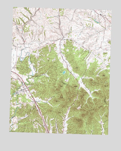
Levee, KY USGS Topographic Map
Click on map above to begin viewing in our Map Viewer.

This topographic map contains these locations and features:
Feature Name Type Latitude Longitude GNIS ID View Map
Argyle Railroad Station (historical)LocaleN37.9063°W83.9693°2420676View Map
Ashgrove (historical)LocaleN37.9687°W83.9971°2508431View Map
Barlow RidgeRidgeN37.9540°W83.9513°486365View Map
Black Creek (historical)Populated PlaceN37.8905°W83.9270°2420699View Map
Black Creek United ChurchChurchN37.9146°W83.9130°2420668View Map
Bowles BranchStreamN37.9806°W83.8813°487734View Map
Bowling ForkStreamN37.9773°W83.8902°487742View Map
Brushy Lick ForkStreamN37.9520°W83.9777°507365View Map
CamargoPopulated PlaceN37.9942°W83.8877°488655View Map
Camargo Post Office (historical)Post OfficeN37.9971°W83.8938°2491588View Map
Camp McKee Boy Scout ReservationLocaleN37.9367°W83.9346°488705View Map
Camp Richard ClarkLocaleN37.9390°W83.9763°2508433View Map
City of CamargoCivilN37.9970°W83.8926°2403973View Map
Combs BranchStreamN37.9523°W83.9966°489901View Map
Cooperas CreekStreamN37.9292°W83.9771°490065View Map
Cream Alley BranchStreamN37.9729°W83.9352°490316View Map
Crooked Ash BranchStreamN37.9965°W83.9702°518071View Map
Douglas PointSummitN37.9223°W83.9196°491063View Map
Dry BranchStreamN37.9881°W83.9766°507363View Map
Faith Pentecostal ChurchChurchN37.9437°W83.9290°2491599View Map
Falls BranchStreamN37.8829°W83.9958°491964View Map
Ficklin KnobSummitN37.9565°W83.8813°492056View Map
Grape KnobSummitN37.9223°W83.9374°493125View Map
Gravel KnobSummitN37.9412°W83.9149°493179View Map
Hardwicks BranchStreamN37.9862°W83.9791°507362View Map
Hidden ValleyValleyN37.8844°W83.9893°2420757View Map
Hisle FieldAirportN37.9462°W83.9964°2444086View Map
Hog CreekStreamN37.9681°W83.9371°494342View Map
Hollywood SpringsLocaleN37.9481°W83.9866°494429View Map
Indian FieldsLocaleN37.9392°W83.9977°494944View Map
Indian Fields HillSummitN37.9406°W83.9806°2508434View Map
Indian Fields Post Office (historical)Post OfficeN37.9395°W83.9970°2508435View Map
Indian Fields Railroad Station (historical)LocaleN37.9394°W83.9972°2508573View Map
Indian Old FieldsLocaleN37.9459°W83.9999°499845View Map
Indian Old Fields BranchStreamN37.9519°W83.9881°2508569View Map
KiddvillePopulated PlaceN37.9598°W83.9930°495721View Map
Kiddville Post Office (historical)Post OfficeN37.9602°W83.9934°2508331View Map
Kit PointSummitN37.8959°W83.9388°495818View Map
LeveePopulated PlaceN37.9712°W83.9352°508449View Map
Levee Post Office (historical)Post OfficeN37.9711°W83.9350°2491616View Map
Levee School (historical)SchoolN37.9649°W83.9400°2491617View Map
Macedonia ChurchChurchN37.9692°W83.9363°497419View Map
Macedonia ChurchChurchN37.9380°W83.9264°2491619View Map
Mary Jane MountainSummitN37.9237°W83.8819°497644View Map
McKenzies ChapelChurchN37.9598°W83.9661°2491620View Map
Montgomery County Fire District Station 3BuildingN37.9947°W83.8907°2636968View Map
Montgomery County Fire District Station 4 LeveeBuildingN37.9530°W83.9374°2636969View Map
Morris MountainSummitN37.9054°W83.8808°514072View Map
Mount Gilead Cumberland Presbyterian ChurchChurchN37.9793°W83.9388°2491624View Map
Mount Sterling ChurchChurchN37.9923°W83.9430°498866View Map
New Providence (historical)Populated PlaceN37.9468°W83.9887°2508570View Map
New Providence Baptist ChurchChurchN37.9488°W83.9855°2508432View Map
North Branch Lulbegrud CreekStreamN37.9598°W83.9830°499536View Map
Oil SpringsLocaleN37.9384°W83.9769°499785View Map
Oil Springs BranchStreamN37.9398°W83.9758°2508571View Map
Oldham PondReservoirN37.9651°W83.9565°2491633View Map
Paint Creek (historical)Populated PlaceN37.8842°W83.8820°2420713View Map
Pilot KnobSummitN37.9112°W83.9358°500647View Map
Pine Grove ChurchChurchN37.9103°W83.9756°2420672View Map
Piolet Knob Historical MarkerParkN37.9055°W83.9684°2744702View Map
Potato KnobSummitN37.9342°W83.8841°501187View Map
Right Fork Hog CreekStreamN37.9136°W83.8979°2420751View Map
Rotten PointSummitN37.9095°W83.9252°502372View Map
Sage PointSummitN37.9079°W83.9421°502559View Map
Spencer Morton PreserveParkN37.9099°W83.9256°2420697View Map
Still House BranchStreamN37.9651°W83.9674°507359View Map
Thomas MillLocaleN37.9453°W83.9077°2491652View Map
Toler MountainSummitN37.9131°W83.9077°505322View Map
Trimble (historical)Populated PlaceN37.9565°W83.8970°2491653View Map
VirdenPopulated PlaceN37.8820°W83.9549°509293View Map
Virden Post Office (historical)Post OfficeN37.8825°W83.9546°2420737View Map
Virden Railroad Station (historical)LocaleN37.8817°W83.9544°2420693View Map
Ware PointSummitN37.8976°W83.9494°506223View Map
Welch KnobSummitN37.9676°W83.8758°516261View Map
WestbendPopulated PlaceN37.9059°W83.9691°506484View Map
Westbend ChurchChurchN37.9170°W83.9805°506485View Map
Westbend Post Office (historical)Post OfficeN37.9067°W83.9694°2420739View Map
Westbrook MountainSummitN37.9262°W83.8902°506487View Map
White Rock MountainSummitN37.8881°W83.9138°506639View Map
White Rock QuarryMineN37.9017°W83.9113°506640View Map
Wildcat KnobSummitN37.8940°W83.8766°506740View Map
Willoughby CemeteryCemeteryN37.9498°W83.8824°506853View Map

Note: Coordinates in the location and feature list above are referenced to NAD83 datum.


Copyright (C) 2008-2024 Ryan Niemi / Sunset Dynamics ... All Rights Reserved