TopoQuest Logo
Do you find TopoQuest useful?
Help keep TopoQuest running and adding new maps/features by donating!
Bitcoin:  19c7KJd3qBynnjoSw5npx9KScwjBe4ifkT
Litecoin:  LXs6TkuXGGXo1vDsWCkWVdjQX94eUKd6ui
Home View Maps Find Maps Find Places Resources & Links


Stanton, Kentucky Topographic Map

USGS Map Title: Stanton, KY
USGS Map MRC: 37083G7
DRG (GeoTIFF) Download: o37083g7.tif


Neighboring USGS Topographic Map Quads:


  Levee, KY  
37083H8
 

  Means, KY  
37083H7
 

  Frenchburg, KY  
37083H6
 

  Clay City, KY  
37083G8
 

  Stanton, KY  
37083G7
 

  Slade, KY  
37083G6
 

  Irvine, KY  
37083F8
 

  Cobhill, KY  
37083F7
 

  Zachariah, KY  
37083F6


Map MRC Location:

N38°
W84°
N38°
W83°
H8 H7 H6 H5 H4 H3 H2 H1
G8 G7 G6 G5 G4 G3 G2 G1
F8 F7 F6 F5 F4 F3 F2 F1
E8 E7 E6 E5 E4 E3 E2 E1
D8 D7 D6 D5 D4 D3 D2 D1
C8 C7 C6 C5 C4 C3 C2 C1
B8 B7 B6 B5 B4 B3 B2 B1
A8 A7 A6 A5 A4 A3 A2 A1
N37°
W84°
N37°
W83°

Stanton, KY USGS 1:24K Topographic Map Preview:
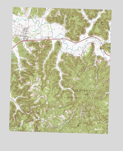
Stanton, KY USGS Topographic Map
Click on map above to begin viewing in our Map Viewer.

This topographic map contains these locations and features:
Feature Name Type Latitude Longitude GNIS ID View Map
Anderson BranchStreamN37.8492°W83.8133°510265View Map
Billings CemeteryCemeteryN37.7607°W83.8344°2440409View Map
Boone BranchStreamN37.8617°W83.8585°510847View Map
BowenPopulated PlaceN37.8412°W83.7719°510864View Map
Bowen Elementary SchoolSchoolN37.8317°W83.7841°510870View Map
Buffalo LicksLocaleN37.7628°W83.8394°2440562View Map
Campton Road (historical)Populated PlaceN37.8446°W83.8367°2420700View Map
Cane CreekStreamN37.8334°W83.7980°511187View Map
Cane Creek ChurchChurchN37.8645°W83.7769°511192View Map
Cat CreekStreamN37.8392°W83.8080°511245View Map
Cat Creek (historical)Populated PlaceN37.8111°W83.8106°2420701View Map
Cat Creek ChurchChurchN37.8109°W83.8110°511246View Map
Chop Chestnut RidgeRidgeN37.8045°W83.7877°511358View Map
City of StantonCivilN37.8475°W83.8571°2405520View Map
Civil War Court House Burnings Historical MarkerParkN37.8531°W83.8595°2744701View Map
Cow CreekStreamN37.8323°W83.7607°511589View Map
Cow Creek MountainSummitN37.8111°W83.7639°2420753View Map
Daniel Boone National Forest Cumberland Ranger District Stanton OfficeBuildingN37.8461°W83.8710°2637446View Map
Daniel BranchStreamN37.7815°W83.8710°511711View Map
East Fork Hatcher CreekStreamN37.8701°W83.8313°511988View Map
Estill Furnace RuinsLocaleN37.7609°W83.8335°512090View Map
Ewen BranchStreamN37.8617°W83.8416°512104View Map
FurnacePopulated PlaceN37.7620°W83.8316°512266View Map
Furnace LakeReservoirN37.7604°W83.8032°2420741View Map
Glencairn Railroad Station (historical)LocaleN37.7653°W83.7653°2420679View Map
Hall BranchStreamN37.8337°W83.7913°512517View Map
Halls CemeteryCemeteryN37.8305°W83.7854°2420666View Map
Hatcher CreekStreamN37.8584°W83.8377°512584View Map
Hatcher Creek ChurchChurchN37.8654°W83.8383°512585View Map
Hatton Creek (historical)Populated PlaceN37.8182°W83.8650°2420705View Map
Hatton Creek CemeteryCemeteryN37.8137°W83.8616°512589View Map
Hatton Creek ChurchChurchN37.8176°W83.8646°512590View Map
Hemlock Lodge (historical)Populated PlaceN37.7753°W83.7753°2420706View Map
High Rock Lookout TowerTowerN37.7884°W83.7777°517174View Map
High RocksLocaleN37.7886°W83.7782°2420680View Map
Judy CreekStreamN37.8611°W83.8715°513089View Map
KnowltonPopulated PlaceN37.7862°W83.8374°513168View Map
Lions Club ParkParkN37.8658°W83.8521°2420696View Map
Lower Cane CreekStreamN37.8551°W83.7752°513680View Map
McKinney CliffCliffN37.8365°W83.7555°513879View Map
Middle Fork Red RiverStreamN37.8409°W83.7630°513934View Map
Mill KnobSummitN37.8384°W83.8155°513994View Map
Morris CreekStreamN37.8640°W83.8574°514066View Map
Morris Creek First Church of GodChurchN37.8684°W83.8585°514067View Map
Mount Canaan ChapelChurchN37.7967°W83.8394°514085View Map
North BendBendN37.8454°W83.8232°2420658View Map
North Bend (historical)Populated PlaceN37.8488°W83.8488°2420710View Map
Pecks CreekStreamN37.8445°W83.8205°514477View Map
Pecks Creek (historical)Populated PlaceN37.8200°W83.8321°2420714View Map
Powell CountyCivilN37.8311°W83.8238°516945View Map
Powell County Ambulance ServiceBuildingN37.8528°W83.8590°2719146View Map
Powell County Historical MarkerParkN37.8522°W83.8599°2745105View Map
Powell County Sheriff's OfficeBuildingN37.8532°W83.8598°2767574View Map
Raven RockSummitN37.8670°W83.7994°514848View Map
Rest Haven CemeteryCemeteryN37.8699°W83.8581°2420667View Map
Right Fork Cane CreekStreamN37.8551°W83.7752°514935View Map
Rogers ChapelLocaleN37.7715°W83.7827°515089View Map
RosslynPopulated PlaceN37.8406°W83.8121°515119View Map
Rosslyn Post Office (historical)Post OfficeN37.8134°W83.8408°2420729View Map
South Fork Red RiverStreamN37.8237°W83.7521°515547View Map
StantonPopulated PlaceN37.8456°W83.8583°515661View Map
Stanton AirportAirportN37.8493°W83.8472°517493View Map
Stanton DivisionCivilN37.8228°W83.7655°1937275View Map
Stanton Fire DepartmentBuildingN37.8536°W83.8585°2636797View Map
Stanton Fire DepartmentBuildingN37.8536°W83.8585°2637130View Map
Stanton InterchangeCrossingN37.8412°W83.8580°517289View Map
Stanton Police DepartmentBuildingN37.8532°W83.8581°2767623View Map
Stanton Ranger StationBuildingN37.8459°W83.8708°516745View Map
State RockSummitN37.7690°W83.8402°515665View Map
The Devils GulchLocaleN37.7784°W83.7784°2420690View Map
Upper Cane (historical)Populated PlaceN37.8693°W83.7646°2420719View Map
Vinton Post Office (historical)Post OfficeN37.7963°W83.8108°2420736View Map
West Fork Hatcher CreekStreamN37.8701°W83.8313°516274View Map
West HollowValleyN37.8722°W83.7654°516277View Map
Wildwood ChurchChurchN37.7879°W83.8374°2420674View Map
WSKV-FM (Stanton)TowerN37.7620°W83.8433°518028View Map
Xena Post Office (historical)Post OfficeN37.7718°W83.7835°2420740View Map

Note: Coordinates in the location and feature list above are referenced to NAD83 datum.


Copyright (C) 2008-2025 Ryan Niemi / Sunset Dynamics ... All Rights Reserved