TopoQuest Logo
Do you find TopoQuest useful?
Help keep TopoQuest running and adding new maps/features by donating!
Bitcoin:  19c7KJd3qBynnjoSw5npx9KScwjBe4ifkT
Litecoin:  LXs6TkuXGGXo1vDsWCkWVdjQX94eUKd6ui
Home View Maps Find Maps Find Places Resources & Links


Clay City, Kentucky Topographic Map

USGS Map Title: Clay City, KY
USGS Map MRC: 37083G8
DRG (GeoTIFF) Download: o37083g8.tif


Neighboring USGS Topographic Map Quads:


  Hedges, KY  
37084H1
 

  Levee, KY  
37083H8
 

  Means, KY  
37083H7
 

  Palmer, KY  
37084G1
 

  Clay City, KY  
37083G8
 

  Stanton, KY  
37083G7
 

  Panola, KY  
37084F1
 

  Irvine, KY  
37083F8
 

  Cobhill, KY  
37083F7


Map MRC Location:

N38°
W84°
N38°
W83°
H8 H7 H6 H5 H4 H3 H2 H1
G8 G7 G6 G5 G4 G3 G2 G1
F8 F7 F6 F5 F4 F3 F2 F1
E8 E7 E6 E5 E4 E3 E2 E1
D8 D7 D6 D5 D4 D3 D2 D1
C8 C7 C6 C5 C4 C3 C2 C1
B8 B7 B6 B5 B4 B3 B2 B1
A8 A7 A6 A5 A4 A3 A2 A1
N37°
W84°
N37°
W83°

Clay City, KY USGS 1:24K Topographic Map Preview:
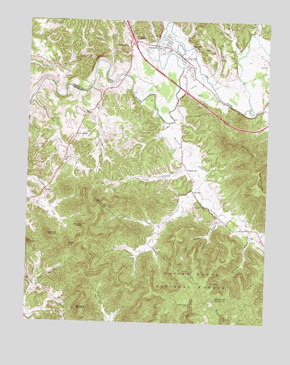
Clay City, KY USGS Topographic Map
Click on map above to begin viewing in our Map Viewer.

This topographic map contains these locations and features:
Feature Name Type Latitude Longitude GNIS ID View Map
Ballard BranchStreamN37.7945°W83.9002°510377View Map
Beech ForkStreamN37.8606°W83.8908°510518View Map
Black CreekStreamN37.8726°W83.9294°510748View Map
Bradley RocksCliffN37.7590°W83.9010°2440428View Map
Bradleys RocksLocaleN37.7590°W83.9022°2420677View Map
Branham BranchStreamN37.7854°W83.8830°510896View Map
Brush CreekStreamN37.8592°W83.9330°510969View Map
Buzzard RoostSummitN37.7895°W83.9702°511114View Map
Calloway Creek (historical)Populated PlaceN37.7703°W83.9884°2440557View Map
Camp BurnamwoodParkN37.7727°W83.9811°2440446View Map
City of Clay CityCivilN37.8622°W83.9277°2404065View Map
Clark CemeteryCemeteryN37.8223°W83.9224°511372View Map
Clark CemeteryCemeteryN37.8654°W83.8988°511373View Map
Clay CityPopulated PlaceN37.8592°W83.9185°511380View Map
Clay City CemeteryCemeteryN37.8620°W83.9302°512004View Map
Clay City DivisionCivilN37.8452°W83.9223°1936936View Map
Clay City Fire DepartmentBuildingN37.8527°W83.9172°2636653View Map
Clay City InterchangeCrossingN37.8659°W83.9452°517112View Map
Clay City Police DepartmentBuildingN37.8613°W83.9229°2767698View Map
Combs BranchStreamN37.7859°W83.9046°511485View Map
Combs RidgeRidgeN37.7873°W83.9208°511491View Map
Cottage Furnace Historical MarkerParkN37.7575°W83.9143°2744288View Map
Cottage Furnace Picnic AreaLocaleN37.7573°W83.9144°516655View Map
Cottage Furnace Post Office (historical)Post OfficeN37.7570°W83.9145°2440476View Map
Cottage Furnace RuinsLocaleN37.7573°W83.9141°511560View Map
Fife Lick CreekStreamN37.8664°W83.9206°2420749View Map
Frames BranchStreamN37.8151°W83.9177°512238View Map
Grassy KnobSummitN37.7820°W83.9780°512389View Map
Great Red River North BendBendN37.8739°W83.9272°2420657View Map
Happy Top (historical)Populated PlaceN37.8269°W83.9556°2420704View Map
Hardwick CreekStreamN37.8326°W83.9263°512561View Map
Hardwick Creek ChurchChurchN37.7979°W83.9066°512562View Map
Hatton CreekStreamN37.8367°W83.8824°512588View Map
Iron and Timber Works Historical MarkerParkN37.8606°W83.9211°2744703View Map
Irvine DivisionCivilN37.7705°W83.9906°1937072View Map
Jackson ChapelChurchN37.8173°W83.9799°512967View Map
Jackson Chapel CemeteryCemeteryN37.8171°W83.9796°2440561View Map
Kaincaid MountainSummitN37.8131°W83.8794°513092View Map
Kennon CemeteryCemeteryN37.7920°W83.9007°513122View Map
KimbrellPopulated PlaceN37.8042°W83.9910°513139View Map
Kimbrell Chapel (historical)ChurchN37.8028°W83.9916°2440426View Map
Kimbrell Post Office (historical)Post OfficeN37.8030°W83.9914°2440486View Map
Kueshner BranchStreamN37.7870°W83.9316°513182View Map
Lewis Martin Grist MillLocaleN37.8644°W83.9336°2420681View Map
Little Hardwick CreekStreamN37.8062°W83.9105°513488View Map
Little Hardwick Creek School (historical)SchoolN37.7851°W83.9303°2420744View Map
Lone Oak (historical)Populated PlaceN37.8574°W83.9912°2420708View Map
Lone Oak SchoolSchoolN37.8614°W83.9930°2420745View Map
Lords Valley Methodist ChurchChurchN37.8651°W83.9146°513637View Map
Marbleyard (historical)Populated PlaceN37.7570°W83.9139°2440546View Map
Marbleyard RidgeRidgeN37.7574°W83.9338°2440516View Map
McKinney MountainSummitN37.7556°W83.9730°513880View Map
Mill Seat CreekStreamN37.8409°W83.9991°513999View Map
Old Clay City Road (historical)Populated PlaceN37.8624°W83.8806°2420711View Map
Paint CreekStreamN37.8698°W83.8830°514419View Map
Piggville (historical)Populated PlaceN37.8641°W83.9066°2420715View Map
Plum BranchStreamN37.8470°W83.9671°514662View Map
Pompeii BranchStreamN37.8492°W83.9044°514688View Map
Pompeii Church Of GodChurchN37.8634°W83.9058°514689View Map
Powell ValleyPopulated PlaceN37.8651°W83.9477°514754View Map
Red River Iron Works (historical)LocaleN37.8654°W83.9349°2420687View Map
Salem ChurchChurchN37.8365°W83.9694°515182View Map
Shawnee Railroad Station (historical)LocaleN37.8654°W83.9350°2420688View Map
Ships BranchStreamN37.8720°W83.9488°515361View Map
Skinner BranchStreamN37.8662°W83.9330°515454View Map
Spout SpringsPopulated PlaceN37.8270°W83.9746°515601View Map
Spout Springs Post Office (historical)Post OfficeN37.8284°W83.9617°2420733View Map
Sproutsprings Post Office (historical)Post OfficeN37.8273°W83.9752°2440507View Map
Stanton Post Office (historical)Post OfficeN37.8489°W83.8898°2420734View Map
Sugarloaf MountainSummitN37.7859°W83.9888°515800View Map
Thorpe BranchStreamN37.8684°W83.8941°515933View Map
Todd ChurchChurchN37.8237°W83.9549°2420673View Map
Tug BranchStreamN37.8515°W83.9591°516032View Map
Union Hall Post Office (historical)Post OfficeN37.7582°W83.9044°2440551View Map
Vaughn MillLocaleN37.8236°W83.9193°2420692View Map
Vaughn Mill Post Office (historical)Post OfficeN37.8228°W83.9334°2420735View Map
Vaughn Mill SchoolSchoolN37.8177°W83.9205°2420747View Map
Vaughns MillPopulated PlaceN37.8131°W83.9166°516178View Map
Vaughns Mill First Church of GodChurchN37.8042°W83.9138°516179View Map
WaltersvillePopulated PlaceN37.8648°W83.9344°516219View Map
Waltersville Post Office (historical)Post OfficeN37.8645°W83.9342°2420738View Map
Watersville BridgeBridgeN37.8647°W83.9332°2420660View Map
White SchoolSchoolN37.8645°W83.9071°2420748View Map

Note: Coordinates in the location and feature list above are referenced to NAD83 datum.


Copyright (C) 2008-2024 Ryan Niemi / Sunset Dynamics ... All Rights Reserved