TopoQuest Logo
Do you find TopoQuest useful?
Help keep TopoQuest running and adding new maps/features by donating!
Bitcoin:  19c7KJd3qBynnjoSw5npx9KScwjBe4ifkT
Litecoin:  LXs6TkuXGGXo1vDsWCkWVdjQX94eUKd6ui
Home View Maps Find Maps Find Places Resources & Links


Basin, Mississippi Topographic Map

USGS Map Title: Basin, MS
USGS Map MRC: 30088G6
DRG (GeoTIFF) Download: o30088g6.tif


Neighboring USGS Topographic Map Quads:


  Avent, MS  
30088H7
 

  Merrill, MS  
30088H6
 

  Lucedale, MS  
30088H5
 

  Benndale, MS  
30088G7
 

  Basin, MS  
30088G6
 

  Agricola, MS  
30088G5
 

  Vestry, MS  
30088F7
 

  Easen Hill, MS  
30088F6
 

  Harleston, MS  
30088F5


Map MRC Location:

N31°
W89°
N31°
W88°
H8 H7 H6 H5 H4 H3 H2 H1
G8 G7 G6 G5 G4 G3 G2 G1
F8 F7 F6 F5 F4 F3 F2 F1
E8 E7 E6 E5 E4 E3 E2 E1
D8 D7 D6 D5 D4 D3 D2 D1
C8 C7 C6 C5 C4 C3 C2 C1
B8 B7 B6 B5 B4 B3 B2 B1
A8 A7 A6 A5 A4 A3 A2 A1
N30°
W89°
N30°
W88°

Basin, MS USGS 1:24K Topographic Map Preview:
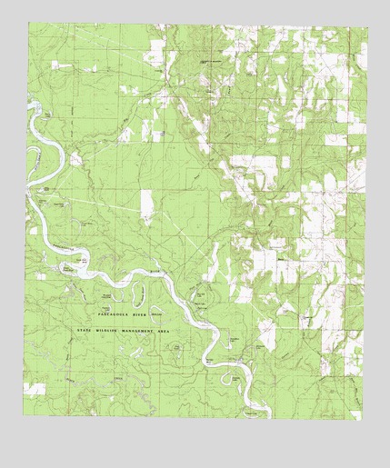
Basin, MS USGS Topographic Map
Click on map above to begin viewing in our Map Viewer.

This topographic map contains these locations and features:
Feature Name Type Latitude Longitude GNIS ID View Map
BasinLocaleN30.8030°W88.6628°666556View Map
Basin Post Office (historical)Post OfficeN30.7821°W88.6481°712621View Map
Basin SchoolSchoolN30.7991°W88.6400°666558View Map
Basin Volunteer Fire DepartmentBuildingN30.8003°W88.6402°2667723View Map
Big CreekStreamN30.8332°W88.7361°667097View Map
Big Creek Boat RampLocaleN30.8334°W88.7355°2596388View Map
Bilbo BasinLakeN30.8217°W88.7443°667162View Map
Bilbo Dead RiverLakeN30.7863°W88.7250°667163View Map
Blue Gill LakeLakeN30.7894°W88.6877°690691View Map
Boneyard LakeLakeN30.7730°W88.6659°667424View Map
Bream LakeLakeN30.7864°W88.6879°690693View Map
Bull Bay BendBendN30.7677°W88.6831°667767View Map
Byrd CemeteryCemeteryN30.7591°W88.6353°690698View Map
Byrd Mill BranchStreamN30.7630°W88.6370°667890View Map
Byrd-Helveston CemeteryCemeteryN30.8041°W88.6606°690700View Map
Calvary ChurchChurchN30.8544°W88.6814°690702View Map
Crossroads ChurchChurchN30.8602°W88.7000°690710View Map
Fairley CemeteryCemeteryN30.8182°W88.6656°690718View Map
Garnett BranchStreamN30.7544°W88.6620°670324View Map
George CountyCivilN30.8626°W88.6440°695744View Map
Gibson CemeteryCemeteryN30.7841°W88.6553°670378View Map
Gibson LandingPopulated PlaceN30.7674°W88.6703°691882View Map
Gibson Landing Boat RampLocaleN30.7684°W88.6709°2596293View Map
Goff Dead RiverLakeN30.7861°W88.7066°670448View Map
Green Dead RiverLakeN30.7950°W88.7327°690726View Map
Harrison LakeLakeN30.7610°W88.6752°670981View Map
Hog PondLakeN30.7739°W88.6941°671265View Map
Horseshoe LakeLakeN30.7726°W88.6752°671484View Map
Howell CemeteryCemeteryN30.8666°W88.6775°671536View Map
Lingum LakeLakeN30.7507°W88.6641°672514View Map
Lower Rines LakeLakeN30.8124°W88.7316°672924View Map
McCrea Dead RiverLakeN30.8286°W88.7467°673322View Map
Mengel Lumber CampLocaleN30.7999°W88.6900°673477View Map
Mountain (historical)Populated PlaceN30.8510°W88.6934°687107View Map
Pascagoula River State Wildlife Management AreaParkN30.7794°W88.7167°705311View Map
Perch LakeLakeN30.7847°W88.6867°690750View Map
Peterson LakeLakeN30.7836°W88.7188°675658View Map
Pierce LakeLakeN30.8442°W88.7425°675721View Map
Pleasant Hill ChurchChurchN30.7821°W88.6478°676057View Map
Plum Bluff CutoffBendN30.7924°W88.6845°676151View Map
Reed FlatFlatN30.8594°W88.6725°676563View Map
Reed Flat CreekStreamN30.7921°W88.6953°690754View Map
Sandy Wash BendBendN30.7999°W88.7314°677398View Map
Scott Paper Company Lake DamDamN30.7602°W88.7267°680490View Map
Smith CutoffGutN30.7757°W88.7270°677932View Map
Supervisor District 3CivilN30.8112°W88.6445°711855View Map
Upper Rines LakeLakeN30.8179°W88.7346°679156View Map
Wells LakeLakeN30.7805°W88.7021°679441View Map
White CreekStreamN30.7932°W88.6842°679583View Map
Wilkerson FerryCrossingN30.8166°W88.7456°679684View Map
Wilkerson Ferry Boat RampLocaleN30.8156°W88.7471°2596689View Map
Willie Cockran Estate Lake DamDamN30.8585°W88.6550°680521View Map
Willie Holcomb Lake DamDamN30.7669°W88.6284°680492View Map
Woodard Dead RiverLakeN30.7871°W88.7146°679835View Map

Note: Coordinates in the location and feature list above are referenced to NAD83 datum.


Copyright (C) 2008-2025 Ryan Niemi / Sunset Dynamics ... All Rights Reserved