TopoQuest Logo
Do you find TopoQuest useful?
Help keep TopoQuest running and adding new maps/features by donating!
Bitcoin:  19c7KJd3qBynnjoSw5npx9KScwjBe4ifkT
Litecoin:  LXs6TkuXGGXo1vDsWCkWVdjQX94eUKd6ui
Home View Maps Find Maps Find Places Resources & Links


Lewisville, Arkansas Topographic Map

USGS Map Title: Lewisville, AR
USGS Map MRC: 33093C5
DRG (GeoTIFF) Download: o33093c5.tif


Neighboring USGS Topographic Map Quads:


  Boyd Hill, AR  
33093D6
 

  Old Town, AR  
33093D5
 

  Falcon, AR  
33093D4
 

  Garland, AR  
33093C6
 

  Lewisville, AR  
33093C5
 

  Buckner, AR  
33093C4
 

  Canfield, AR  
33093B6
 

  Bradley NE, AR  
33093B5
 

  Bussey, AR  
33093B4


Map MRC Location:

N34°
W94°
N34°
W93°
H8 H7 H6 H5 H4 H3 H2 H1
G8 G7 G6 G5 G4 G3 G2 G1
F8 F7 F6 F5 F4 F3 F2 F1
E8 E7 E6 E5 E4 E3 E2 E1
D8 D7 D6 D5 D4 D3 D2 D1
C8 C7 C6 C5 C4 C3 C2 C1
B8 B7 B6 B5 B4 B3 B2 B1
A8 A7 A6 A5 A4 A3 A2 A1
N33°
W94°
N33°
W93°

Lewisville, AR USGS 1:24K Topographic Map Preview:
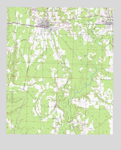
Lewisville, AR USGS Topographic Map
Click on map above to begin viewing in our Map Viewer.

This topographic map contains these locations and features:
Feature Name Type Latitude Longitude GNIS ID View Map
Battle CreekStreamN33.3507°W93.5743°46156View Map
Bethel ChurchChurchN33.2648°W93.5682°46438View Map
City of LewisvilleCivilN33.3574°W93.5746°2404919View Map
Crooked BranchStreamN33.3432°W93.5185°48169View Map
Crossroads ChurchChurchN33.3432°W93.6074°48219View Map
Hickory Grove ChurchChurchN33.3162°W93.5602°50061View Map
Kress CityPopulated PlaceN33.2943°W93.6049°57082View Map
Lafayette County Ambulance ServiceBuildingN33.3600°W93.5613°2119030View Map
Lafayette County Middle SchoolSchoolN33.3581°W93.5882°2039361View Map
Lafayette County Sheriff's OfficeBuildingN33.3576°W93.5770°2118900View Map
Lafayette County West Elementary SchoolSchoolN33.3613°W93.5790°2039360View Map
LewisvillePopulated PlaceN33.3585°W93.5777°77484View Map
Lewisville High SchoolSchoolN33.3585°W93.5882°62483View Map
Lewisville Middle SchoolSchoolN33.3618°W93.5791°62484View Map
Lewisville Oil and Gas FieldOilfieldN33.3446°W93.5377°62485View Map
Lewisville Police DepartmentBuildingN33.3559°W93.5812°2118899View Map
Lewisville Post OfficePost OfficeN33.3557°W93.5749°2781878View Map
Lewisville Volunteer Fire StationBuildingN33.3559°W93.5812°2116710View Map
Mars HillLocaleN33.2596°W93.5338°77599View Map
Mars Hill CemeteryCemeteryN33.2621°W93.5421°51686View Map
Mars Hill Oil and Gas FieldOilfieldN33.2535°W93.5516°62486View Map
Mars Hill Volunteer Fire DepartmentBuildingN33.2595°W93.5324°2116767View Map
Rawls CreekStreamN33.3073°W93.6243°53917View Map
Red BranchStreamN33.3229°W93.5216°53935View Map
Saint James ChurchChurchN33.3598°W93.6152°54338View Map
Steel CreekStreamN33.2907°W93.5438°55186View Map
Tatum BranchStreamN33.3654°W93.5216°55452View Map
Township of Mars HillCivilN33.2620°W93.5592°66777View Map

Note: Coordinates in the location and feature list above are referenced to NAD83 datum.


Copyright (C) 2008-2024 Ryan Niemi / Sunset Dynamics ... All Rights Reserved