TopoQuest Logo
Do you find TopoQuest useful?
Help keep TopoQuest running and adding new maps/features by donating!
Bitcoin:  19c7KJd3qBynnjoSw5npx9KScwjBe4ifkT
Litecoin:  LXs6TkuXGGXo1vDsWCkWVdjQX94eUKd6ui
Home View Maps Find Maps Find Places Resources & Links


Old Town, Arkansas Topographic Map

USGS Map Title: Old Town, AR
USGS Map MRC: 33093D5
DRG (GeoTIFF) Download: o33093d5.tif


Neighboring USGS Topographic Map Quads:


  Spring Hill, AR  
33093E6
 

  Patmos, AR  
33093E5
 

  Bodcaw, AR  
33093E4
 

  Boyd Hill, AR  
33093D6
 

  Old Town, AR  
33093D5
 

  Falcon, AR  
33093D4
 

  Garland, AR  
33093C6
 

  Lewisville, AR  
33093C5
 

  Buckner, AR  
33093C4


Map MRC Location:

N34°
W94°
N34°
W93°
H8 H7 H6 H5 H4 H3 H2 H1
G8 G7 G6 G5 G4 G3 G2 G1
F8 F7 F6 F5 F4 F3 F2 F1
E8 E7 E6 E5 E4 E3 E2 E1
D8 D7 D6 D5 D4 D3 D2 D1
C8 C7 C6 C5 C4 C3 C2 C1
B8 B7 B6 B5 B4 B3 B2 B1
A8 A7 A6 A5 A4 A3 A2 A1
N33°
W94°
N33°
W93°

Old Town, AR USGS 1:24K Topographic Map Preview:
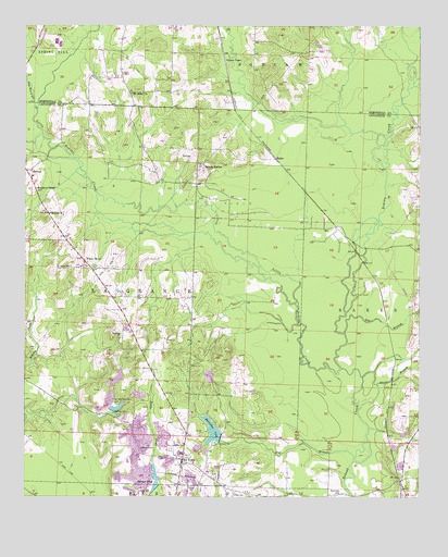
Old Town, AR USGS Topographic Map
Click on map above to begin viewing in our Map Viewer.

This topographic map contains these locations and features:
Feature Name Type Latitude Longitude GNIS ID View Map
BakerPopulated PlaceN33.4648°W93.5460°57301View Map
Barmes PondReservoirN33.3778°W93.5839°76234View Map
Big BranchStreamN33.3843°W93.5213°46508View Map
Bog BranchStreamN33.4190°W93.5241°46792View Map
Buehler Herndon Lake Number One DamDamN33.3968°W93.5968°80576View Map
Buehler Herndon Lake Number TwoReservoirN33.4067°W93.5956°80575View Map
Buehler Herndon Number One ReservoirReservoirN33.3968°W93.5968°80577View Map
Buehler-Herndon Lake Number Two DamDamN33.4051°W93.5968°80574View Map
Cook BranchStreamN33.4451°W93.5021°47972View Map
Davis BranchStreamN33.4068°W93.5185°48378View Map
Dobson StationLocaleN33.4637°W93.5707°48540View Map
Flat Bois d'Arc CreekStreamN33.4782°W93.6213°49088View Map
Hennessey (historical)Populated PlaceN33.4798°W93.5596°61468View Map
Knighton ChapelChurchN33.4568°W93.6216°50895View Map
Little Bodcau CreekStreamN33.4093°W93.5249°51203View Map
Meriwether PondReservoirN33.3927°W93.5656°77648View Map
Meriwether Pond DamDamN33.3910°W93.5635°80578View Map
MidwayPopulated PlaceN33.4618°W93.6249°77652View Map
Midway Boyd Hill Fire StationBuildingN33.4502°W93.6174°2116793View Map
Midway ChurchChurchN33.4504°W93.6171°51946View Map
Midway Oil and Gas FieldOilfieldN33.4529°W93.5655°62488View Map
Mount Nebo Missionary Baptist ChurchChurchN33.4823°W93.5918°77724View Map
Mourning Port ChurchChurchN33.4079°W93.6249°81958View Map
New Meriwether PondReservoirN33.3989°W93.5960°75799View Map
Old Lewisville CemeteryCemeteryN33.3879°W93.5788°53004View Map
Old TownPopulated PlaceN33.3848°W93.5757°58305View Map
Piney GrovePopulated PlaceN33.4379°W93.6063°58385View Map
Sewell CemeteryCemeteryN33.4362°W93.6107°54678View Map
Stricklin CemeteryCemeteryN33.3876°W93.5871°55272View Map
Sunview ChurchChurchN33.3762°W93.5266°55355View Map
Thomas BranchStreamN33.4454°W93.5149°55520View Map
Township of BakerCivilN33.3913°W93.5085°66773View Map
Township of La GrangeCivilN33.4286°W93.5883°66776View Map
Tucker BranchStreamN33.4673°W93.5110°55677View Map
Turner ChapelChurchN33.4910°W93.5624°55740View Map
Wilson CemeteryCemeteryN33.3765°W93.5729°56429View Map

Note: Coordinates in the location and feature list above are referenced to NAD83 datum.


Copyright (C) 2008-2024 Ryan Niemi / Sunset Dynamics ... All Rights Reserved