TopoQuest Logo
Do you find TopoQuest useful?
Help keep TopoQuest running and adding new maps/features by donating!
Bitcoin:  19c7KJd3qBynnjoSw5npx9KScwjBe4ifkT
Litecoin:  LXs6TkuXGGXo1vDsWCkWVdjQX94eUKd6ui
Home View Maps Find Maps Find Places Resources & Links


Lillamay, Tennessee Topographic Map

USGS Map Title: Lillamay, TN
USGS Map MRC: 36087B1
DRG (GeoTIFF) Download: o36087b1.tif


Neighboring USGS Topographic Map Quads:


  Cheatham Dam, TN  
36087C2
 

  Ashland City, TN  
36087C1
 

  Forest Grove, TN  
36086C8
 

  Harpeth Valley, TN  
36087B2
 

  Lillamay, TN  
36087B1
 

  Scottsboro, TN  
36086B8
 

  White Bluff, TN  
36087A2
 

  Kingston Springs, TN  
36087A1
 

  Bellevue, TN  
36086A8


Map MRC Location:

N37°
W88°
N37°
W87°
H8 H7 H6 H5 H4 H3 H2 H1
G8 G7 G6 G5 G4 G3 G2 G1
F8 F7 F6 F5 F4 F3 F2 F1
E8 E7 E6 E5 E4 E3 E2 E1
D8 D7 D6 D5 D4 D3 D2 D1
C8 C7 C6 C5 C4 C3 C2 C1
B8 B7 B6 B5 B4 B3 B2 B1
A8 A7 A6 A5 A4 A3 A2 A1
N36°
W88°
N36°
W87°

Lillamay, TN USGS 1:24K Topographic Map Preview:
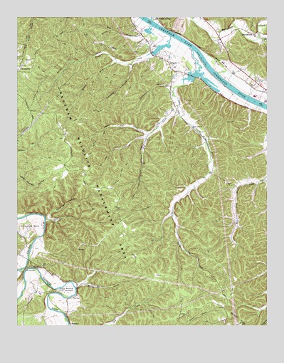
Lillamay, TN USGS Topographic Map
Click on map above to begin viewing in our Map Viewer.

This topographic map contains these locations and features:
Feature Name Type Latitude Longitude GNIS ID View Map
Ashland City Fire Department Station 2BuildingN36.2409°W87.0214°2653866View Map
Barton LandingLocaleN36.2181°W87.0083°1644878View Map
Blue CreekStreamN36.2464°W87.0567°1277750View Map
Brush CreekStreamN36.2423°W87.0478°1278673View Map
Brush Creek Access AreaParkN36.2378°W87.0550°1644881View Map
Carney CemeteryCemeteryN36.2406°W87.0006°1279690View Map
Cedar Hill School (historical)SchoolN36.1501°W87.1119°1317249View Map
Cheatham County LandfillLocaleN36.1367°W87.0400°2677896View Map
Cheatham County Poor House (historical)BuildingN36.2495°W87.0542°1644884View Map
Cheatham State Wildlife Management AreaParkN36.1864°W87.0842°1269444View Map
Commissioner District 5CivilN36.1956°W87.0781°2464427View Map
Dry CreekStreamN36.2148°W87.0439°1282920View Map
Gardling HollowValleyN36.1685°W87.1084°1285156View Map
GravelottePopulated PlaceN36.2242°W87.0064°1310761View Map
Hoopers LandingLocaleN36.2373°W87.0378°1644880View Map
Horseshoe BendBendN36.1662°W87.1169°1288433View Map
Knights Ferry (historical)CrossingN36.2231°W87.0206°1644879View Map
LillamayPopulated PlaceN36.2320°W87.0494°1291277View Map
Lillamay School (historical)SchoolN36.2262°W87.0508°1317252View Map
Little Dry CreekStreamN36.2028°W87.0592°1291478View Map
Little Marrowbone CreekStreamN36.2414°W87.0042°1291562View Map
MarrowbonePopulated PlaceN36.2431°W87.0069°1315468View Map
Marrowbone CreekStreamN36.2492°W87.0572°1292728View Map
Marrowbone School (historical)SchoolN36.2439°W87.0172°1317251View Map
Middle Fork Brush CreekStreamN36.2320°W87.0747°1293666View Map
Mound BottomBendN36.1395°W87.0992°1294537View Map
Mound Bottom (historical)Populated PlaceN36.1389°W87.1014°1644876View Map
Mound CreekStreamN36.1403°W87.0953°1294538View Map
Patterson Forge (historical)LocaleN36.1473°W87.1222°1317243View Map
Possumtrot BranchStreamN36.2309°W87.0675°1298306View Map
Sams CreekStreamN36.2367°W87.0369°1300642View Map
Sams Creek ChurchChurchN36.2056°W87.0369°1300643View Map
Sams Creek School (historical)SchoolN36.1862°W87.0269°1317250View Map
Sandy RunStreamN36.2492°W87.0369°1300768View Map
Scott CemeteryCemeteryN36.1364°W87.0969°1300933View Map
Shearons LandingLocaleN36.2445°W87.0533°1644882View Map
Spring HollowValleyN36.1678°W87.1107°1271122View Map
Stillhouse BranchStreamN36.2212°W87.0464°1271402View Map
Stumps LandingLocaleN36.2134°W87.0028°1644877View Map
Sulphur SpringSpringN36.2495°W87.0536°1650777View Map
Sulphur SpringsPopulated PlaceN36.2495°W87.0542°1314357View Map
Sulphur Springs LandingLocaleN36.2467°W87.0533°1644883View Map
The NarrowsGapN36.1484°W87.1200°1304059View Map
Two Rivers Volunteer Fire Department Station 2BuildingN36.2290°W87.0473°2654273View Map

Note: Coordinates in the location and feature list above are referenced to NAD83 datum.


Copyright (C) 2008-2024 Ryan Niemi / Sunset Dynamics ... All Rights Reserved