TopoQuest Logo
Do you find TopoQuest useful?
Help keep TopoQuest running and adding new maps/features by donating!
Bitcoin:  19c7KJd3qBynnjoSw5npx9KScwjBe4ifkT
Litecoin:  LXs6TkuXGGXo1vDsWCkWVdjQX94eUKd6ui
Home View Maps Find Maps Find Places Resources & Links


Cheatham Dam, Tennessee Topographic Map

USGS Map Title: Cheatham Dam, TN
USGS Map MRC: 36087C2
DRG (GeoTIFF) Download: o36087c2.tif


Neighboring USGS Topographic Map Quads:


  Excell, TN  
36087D3
 

  Henrietta, TN  
36087D2
 

  Pleasant View, TN  
36087D1
 

  Cumberland Furnace, TN  
36087C3
 

  Cheatham Dam, TN  
36087C2
 

  Ashland City, TN  
36087C1
 

  Charlotte, TN  
36087B3
 

  Harpeth Valley, TN  
36087B2
 

  Lillamay, TN  
36087B1


Map MRC Location:

N37°
W88°
N37°
W87°
H8 H7 H6 H5 H4 H3 H2 H1
G8 G7 G6 G5 G4 G3 G2 G1
F8 F7 F6 F5 F4 F3 F2 F1
E8 E7 E6 E5 E4 E3 E2 E1
D8 D7 D6 D5 D4 D3 D2 D1
C8 C7 C6 C5 C4 C3 C2 C1
B8 B7 B6 B5 B4 B3 B2 B1
A8 A7 A6 A5 A4 A3 A2 A1
N36°
W88°
N36°
W87°

Cheatham Dam, TN USGS 1:24K Topographic Map Preview:
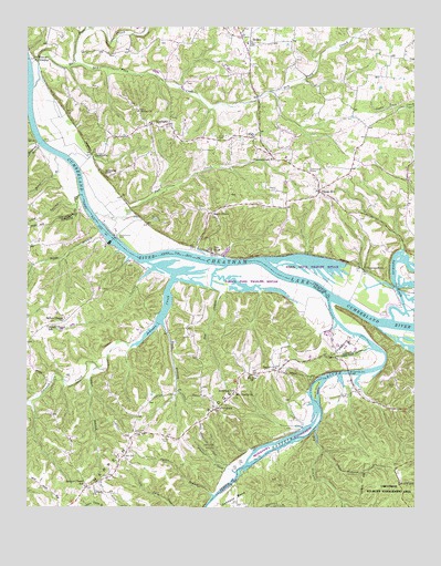
Cheatham Dam, TN USGS Topographic Map
Click on map above to begin viewing in our Map Viewer.

This topographic map contains these locations and features:
Feature Name Type Latitude Longitude GNIS ID View Map
Antioch ChurchChurchN36.2548°W87.2281°1275810View Map
Barton CemeteryCemeteryN36.3570°W87.2369°1326226View Map
Baxters LandingLocaleN36.3448°W87.2464°1317229View Map
Bear BranchStreamN36.3131°W87.1861°1313301View Map
Beech GrovePopulated PlaceN36.3267°W87.1911°1276819View Map
Bell-Hollis CemeteryCemeteryN36.3592°W87.1742°1326228View Map
BellsburgPopulated PlaceN36.2759°W87.1889°1305096View Map
Bellsburg SchoolSchoolN36.2803°W87.1825°1276968View Map
BethelPopulated PlaceN36.3714°W87.1783°1314670View Map
Bethel CemeteryCemeteryN36.3709°W87.1778°1326229View Map
Bethel ChurchChurchN36.2864°W87.1697°1305146View Map
Bethel ChurchChurchN36.3534°W87.2145°1305148View Map
Bethel Freewill Baptist ChurchChurchN36.3714°W87.1778°1326230View Map
Bethel School (historical)SchoolN36.3542°W87.1789°1317227View Map
Betsystown (historical)Populated PlaceN36.3195°W87.2264°1313306View Map
Betsystown LandingLocaleN36.3206°W87.2256°1324011View Map
Big Bethany CreekStreamN36.2712°W87.1564°1269334View Map
Bobbitt-Forbes CemeteryCemeteryN36.3514°W87.2033°1326231View Map
Buck BranchStreamN36.2981°W87.2067°1278795View Map
Cave Spring BranchStreamN36.3314°W87.2333°1279965View Map
ChapmansboroPopulated PlaceN36.3123°W87.1414°1314821View Map
Chapmansboro Post OfficePost OfficeN36.3331°W87.1559°1648557View Map
Cheap HillPopulated PlaceN36.3326°W87.1561°1305870View Map
Cheap Hill Church of ChristChurchN36.3320°W87.1561°1326233View Map
Cheatham DamDamN36.3201°W87.2225°1280307View Map
Cheatham Damsite Access AreaParkN36.3170°W87.2042°1644861View Map
Cheatham Damsite Tailwater Access PointParkN36.3245°W87.2264°1644863View Map
Cheatham LakeReservoirN36.3201°W87.2225°1280308View Map
Clifton CemeteryCemeteryN36.3656°W87.1775°1326234View Map
Clifton ChurchChurchN36.3464°W87.1764°1305974View Map
Clifton Methodist Church CemeteryCemeteryN36.3489°W87.1744°1954769View Map
Commissioner District 4CivilN36.3537°W87.1563°2464019View Map
Cooper Gupton CemeteryCemeteryN36.3681°W87.1864°1326235View Map
Currents LandingLocaleN36.3384°W87.2333°1644864View Map
Daniels CemeteryCemeteryN36.2687°W87.2053°1282033View Map
DoddsvillePopulated PlaceN36.3423°W87.2292°1314952View Map
Doe HollowValleyN36.3057°W87.1876°1282579View Map
Doubledays LandingLocaleN36.3059°W87.1514°1644852View Map
DozierPopulated PlaceN36.2801°W87.1433°1644866View Map
Dry Fork CreekStreamN36.3651°W87.2353°1282980View Map
Dyson Ditch Wildlife RefugeParkN36.3126°W87.1583°1317228View Map
Eatherly-Stewart CemeteryCemeteryN36.3250°W87.1431°1326240View Map
Edwards LandingLocaleN36.2981°W87.1253°1644851View Map
Fall CreekStreamN36.3264°W87.2283°1284068View Map
Fambrough CemeteryCemeteryN36.3364°W87.1906°1326242View Map
Fambroughs LandingLocaleN36.3151°W87.1897°1644858View Map
Fox BluffPopulated PlaceN36.3162°W87.1903°1315075View Map
Frazier CemeteryCemeteryN36.3709°W87.2069°1326243View Map
Gibbs CemeteryCemeteryN36.2823°W87.1308°1285334View Map
Half Pone CreekStreamN36.3595°W87.2481°1286544View Map
Hands BranchStreamN36.3214°W87.2264°1306540View Map
Harpeth Ferry (historical)CrossingN36.3084°W87.1583°1644853View Map
Harpeth RidgeRidgeN36.2689°W87.2097°1286924View Map
Harpeth Ridge Volunteer Fire DepartmentBuildingN36.2747°W87.1906°2653777View Map
Harpeth RiverStreamN36.3037°W87.1528°1303466View Map
Harpeth River Bridge Access PointParkN36.2845°W87.1453°1644849View Map
Harpeth ShoalsBarN36.3112°W87.1700°1644855View Map
Harris-Douglas CemeteryCemeteryN36.3667°W87.1631°1326245View Map
Hegwood LandingLocaleN36.3456°W87.2445°1644865View Map
Henrietta Volunteer Fire Department Station 2BuildingN36.3433°W87.1725°2654263View Map
Hinton CrossingPopulated PlaceN36.3667°W87.2475°1315240View Map
Hudgens CemeteryCemeteryN36.3664°W87.1261°1326248View Map
Indian Ford (historical)CrossingN36.3139°W87.1903°1644859View Map
Jackie BranchStreamN36.2531°W87.1897°1289165View Map
Jackson ChapelPopulated PlaceN36.2556°W87.2306°1313334View Map
Jackson Chapel CemeteryCemeteryN36.2578°W87.2319°1324118View Map
Jackson Chapel Methodist ChurchChurchN36.2556°W87.2314°1324119View Map
Jackson Chapel SchoolSchoolN36.2562°W87.2308°1306615View Map
Johnson BranchStreamN36.2592°W87.1828°1289531View Map
Johnson CreekStreamN36.3098°W87.2031°1306632View Map
Jones BranchStreamN36.3414°W87.2406°1289709View Map
Justice CemeteryCemeteryN36.3678°W87.2219°1326250View Map
Little Bethany CreekStreamN36.2651°W87.1547°1291383View Map
Lock A (historical)DamN36.3151°W87.1922°1644857View Map
Lock A Recreation AreaParkN36.3159°W87.1869°1644856View Map
Locust BranchStreamN36.2867°W87.2270°1291781View Map
Major CemeteryCemeteryN36.3725°W87.2383°1326253View Map
Mayberry BranchStreamN36.3442°W87.2458°1293002View Map
Mayberry Branch Access ParkParkN36.3453°W87.2470°1644850View Map
Millers Chapel Freewill Baptist ChurchChurchN36.2989°W87.2383°1306752View Map
Millers Chapel SchoolSchoolN36.2970°W87.2436°1306753View Map
Montgomery Bell BridgeBridgeN36.2853°W87.1461°1294192View Map
Mount Liberty CemeteryCemeteryN36.2792°W87.1833°1324145View Map
Mount Liberty ChurchChurchN36.2795°W87.1833°1306771View Map
Mount Zion ChurchChurchN36.2848°W87.1775°1306801View Map
NeptunePopulated PlaceN36.3498°W87.2047°1295394View Map
Neptune United Methodist ChurchChurchN36.3498°W87.2122°1326255View Map
New Hope CemeteryCemeteryN36.3553°W87.2167°1326256View Map
Newtons LandingLocaleN36.3164°W87.1989°1644860View Map
Nicholson CemeteryCemeteryN36.3609°W87.1983°1326259View Map
Pack IslandIslandN36.2809°W87.1572°1296642View Map
Page CemeteryCemeteryN36.3595°W87.2275°1326260View Map
Pardue (historical)Populated PlaceN36.3034°W87.1542°1313343View Map
Pardue CemeteryCemeteryN36.3312°W87.1572°1326261View Map
Pardue Pond Wildlife RefugeParkN36.3089°W87.1783°1324166View Map
Pardues LandingLocaleN36.3048°W87.1542°1646324View Map
Pardues Wood Yard (historical)LocaleN36.3131°W87.1794°1646325View Map
Reids ReefBarN36.3092°W87.1644°1644854View Map
Rowerths LandingLocaleN36.3134°W87.2139°1646326View Map
Shearon Family CemeteryCemeteryN36.3567°W87.1278°2087501View Map
Skaggs CemeteryCemeteryN36.3203°W87.1942°1270417View Map
Smith CemeteryCemeteryN36.3462°W87.1889°1303671View Map
Stewart CemeteryCemeteryN36.3328°W87.1697°1271365View Map
Stones LandingLocaleN36.3201°W87.2203°1646059View Map
Sycamore CreekStreamN36.2992°W87.1322°1272002View Map
Teasley CemeteryCemeteryN36.3589°W87.1589°1326266View Map
Walton CemeteryCemeteryN36.3748°W87.1800°1326267View Map
Weakley CemeteryCemeteryN36.3317°W87.1844°1326268View Map
Wheeless-Green CemeteryCemeteryN36.3725°W87.2081°1326269View Map
Whifferdill AirportAirportN36.3214°W87.1524°2675498View Map
Whirl Pool LandingLocaleN36.3278°W87.2320°1646327View Map
Williams-Shearon CemeteryCemeteryN36.3373°W87.1475°1326270View Map
Williamsons Cribs (historical)LocaleN36.3173°W87.2170°1644862View Map

Note: Coordinates in the location and feature list above are referenced to NAD83 datum.


Copyright (C) 2008-2024 Ryan Niemi / Sunset Dynamics ... All Rights Reserved