TopoQuest Logo
Do you find TopoQuest useful?
Help keep TopoQuest running and adding new maps/features by donating!
Bitcoin:  19c7KJd3qBynnjoSw5npx9KScwjBe4ifkT
Litecoin:  LXs6TkuXGGXo1vDsWCkWVdjQX94eUKd6ui
Home View Maps Find Maps Find Places Resources & Links


Ashland City, Tennessee Topographic Map

USGS Map Title: Ashland City, TN
USGS Map MRC: 36087C1
DRG (GeoTIFF) Download: o36087c1.tif


Neighboring USGS Topographic Map Quads:


  Henrietta, TN  
36087D2
 

  Pleasant View, TN  
36087D1
 

  Springfield South, TN  
36086D8
 

  Cheatham Dam, TN  
36087C2
 

  Ashland City, TN  
36087C1
 

  Forest Grove, TN  
36086C8
 

  Harpeth Valley, TN  
36087B2
 

  Lillamay, TN  
36087B1
 

  Scottsboro, TN  
36086B8


Map MRC Location:

N37°
W88°
N37°
W87°
H8 H7 H6 H5 H4 H3 H2 H1
G8 G7 G6 G5 G4 G3 G2 G1
F8 F7 F6 F5 F4 F3 F2 F1
E8 E7 E6 E5 E4 E3 E2 E1
D8 D7 D6 D5 D4 D3 D2 D1
C8 C7 C6 C5 C4 C3 C2 C1
B8 B7 B6 B5 B4 B3 B2 B1
A8 A7 A6 A5 A4 A3 A2 A1
N36°
W88°
N36°
W87°

Ashland City, TN USGS 1:24K Topographic Map Preview:
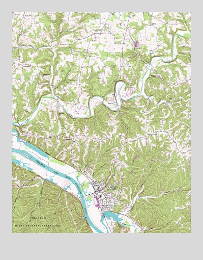
Ashland City, TN USGS Topographic Map
Click on map above to begin viewing in our Map Viewer.

This topographic map contains these locations and features:
Feature Name Type Latitude Longitude GNIS ID View Map
Ashland CityPopulated PlaceN36.2742°W87.0642°1304885View Map
Ashland City Division (historical)CensusN36.2723°W87.0217°1648637View Map
Ashland City DockLocaleN36.2687°W87.0764°1644874View Map
Ashland City Elementary SchoolSchoolN36.2731°W87.0492°1317233View Map
Ashland City Fire Department Station 1BuildingN36.2751°W87.0629°2653671View Map
Ashland City First Baptist ChurchChurchN36.2795°W87.0669°1644873View Map
Ashland City Police DepartmentBuildingN36.2750°W87.0627°2765717View Map
Ashland City Post OfficePost OfficeN36.2748°W87.0665°1650764View Map
Bearwallow ChurchChurchN36.3059°W87.0283°1276665View Map
BethlehemPopulated PlaceN36.3020°W87.0828°1277151View Map
Bethlehem ChurchChurchN36.3176°W87.0933°1305176View Map
Big Bluff CreekStreamN36.2831°W87.0950°1269335View Map
Big Bluff Creek Access AreaParkN36.2798°W87.0992°1644871View Map
Binkley CemeteryCemeteryN36.3425°W87.0494°1277486View Map
Blue Spring CemeteryCemeteryN36.3237°W87.0150°1277799View Map
Blue Spring CreekStreamN36.3284°W87.0369°1305312View Map
Boston HollowValleyN36.2709°W87.0383°1278017View Map
Boston Hollow BranchStreamN36.2703°W87.0392°1647406View Map
Brinkley BranchStreamN36.2623°W87.0606°1278403View Map
Centennial Medical Center at Ashland CityHospitalN36.2772°W87.0657°2697309View Map
Central High SchoolSchoolN36.2706°W87.0633°1317234View Map
Cheatham CountyCivilN36.2612°W87.0868°1639731View Map
Cheatham County CourthouseBuildingN36.2748°W87.0633°1317235View Map
Cheatham County Emergency ManagementBuildingN36.2748°W87.0632°2654277View Map
Cheatham County Sheriff's OfficeBuildingN36.2748°W87.0632°2765818View Map
Cobb Hollow CreekStreamN36.2726°W87.0786°1644872View Map
Cochran Community CenterLocaleN36.3364°W87.0797°1280846View Map
Commissioner District 1CivilN36.2675°W87.0300°2464216View Map
Crockets LandingLocaleN36.2828°W87.0872°1644868View Map
Dodge LandingLocaleN36.2792°W87.0842°1644869View Map
Dry Fork CreekStreamN36.2603°W87.0517°1282975View Map
Fannie Field CemeteryCemeteryN36.3048°W87.0897°1284118View Map
Felts CemeteryCemeteryN36.3312°W87.0903°1284200View Map
Flax Patch Dam (historical)DamN36.2912°W87.1086°1644867View Map
Forest Hill CemeteryCemeteryN36.2687°W87.0564°1284592View Map
GreenbrierPopulated PlaceN36.2764°W87.1181°1286140View Map
Greenbrier School (historical)SchoolN36.2756°W87.1183°1317232View Map
Happy HollowValleyN36.3693°W87.0050°1310755View Map
Harpeth IslandIslandN36.2939°W87.1144°1286922View Map
Harris CemeteryCemeteryN36.3442°W87.0553°1286971View Map
Hudgens CemeteryCemeteryN36.3342°W87.0864°1288609View Map
Hunt CemeteryCemeteryN36.3467°W87.1161°1288716View Map
Lenox BranchStreamN36.2731°W87.0739°1291022View Map
Little Bluff CreekStreamN36.2784°W87.0833°1291394View Map
LockertsvillePopulated PlaceN36.3459°W87.1208°1291772View Map
Lockertsville ChurchChurchN36.3387°W87.1042°1291773View Map
Marks CreekStreamN36.2698°W87.0747°1292700View Map
Miles LandingLocaleN36.2856°W87.1006°1644870View Map
Pleasant View Division (historical)CensusN36.3745°W87.1194°1648639View Map
Poplar RidgeRidgeN36.3731°W87.1172°1298214View Map
Slick HollowValleyN36.3456°W87.0290°1270508View Map
Smith CemeteryCemeteryN36.3434°W87.1053°1270636View Map
Spring CreekStreamN36.3270°W87.0992°1271087View Map
Sugar Fork CreekStreamN36.3548°W87.0986°1271678View Map
Sweet Home Community CenterLocaleN36.3651°W87.0628°1271972View Map
SycamorePopulated PlaceN36.3220°W87.0531°1314370View Map
Sycamore ChapelChurchN36.3387°W87.0239°1303977View Map
Sycamore Middle SchoolSchoolN36.3681°W87.0494°1317230View Map
Sycamore Powder Mill Landing (historical)LocaleN36.2648°W87.0731°1644875View Map
Teasley CemeteryCemeteryN36.3417°W87.0917°1272266View Map
Teasley HollowValleyN36.3316°W87.0963°1272267View Map
Town of Ashland CityCivilN36.2727°W87.0595°2405175View Map
Triangle Community CenterLocaleN36.3692°W87.0289°1272871View Map
Turner-Pardue CemeteryCemeteryN36.2903°W87.0822°1273088View Map
Two Rivers Volunteer Fire Department Station 1BuildingN36.2756°W87.1184°2653640View Map
Vick BranchStreamN36.2678°W87.0406°1273447View Map
WAJN-AM (Ashland City)TowerN36.2856°W87.0828°1639972View Map
Walker CemeteryCemeteryN36.3714°W87.0703°1273613View Map
West Cheatham Elementary SchoolSchoolN36.3039°W87.0933°1317231View Map
Whisky HillSummitN36.3528°W87.0294°1274308View Map

Note: Coordinates in the location and feature list above are referenced to NAD83 datum.


Copyright (C) 2008-2024 Ryan Niemi / Sunset Dynamics ... All Rights Reserved