TopoQuest Logo
Do you find TopoQuest useful?
Help keep TopoQuest running and adding new maps/features by donating!
Bitcoin:  19c7KJd3qBynnjoSw5npx9KScwjBe4ifkT
Litecoin:  LXs6TkuXGGXo1vDsWCkWVdjQX94eUKd6ui
Home View Maps Find Maps Find Places Resources & Links


Limestone, New York Topographic Map

USGS Map Title: Limestone, NY
USGS Map MRC: 42078A6
DRG (GeoTIFF) Download: o42078a6.tif


Neighboring USGS Topographic Map Quads:


  Little Valley, NY  
42078B7
 

  Salamanca, NY  
42078B6
 

  Humphrey, NY  
42078B5
 

  Red House, NY  
42078A7
 

  Limestone, NY  
42078A6
 

  Knapp Creek, NY  
42078A5
 

  Stickney, PA  
41078H7
 

  Bradford, PA  
41078H6
 

  Derrick City, PA  
41078H5


Map MRC Location:

N43°
W79°
N43°
W78°
H8 H7 H6 H5 H4 H3 H2 H1
G8 G7 G6 G5 G4 G3 G2 G1
F8 F7 F6 F5 F4 F3 F2 F1
E8 E7 E6 E5 E4 E3 E2 E1
D8 D7 D6 D5 D4 D3 D2 D1
C8 C7 C6 C5 C4 C3 C2 C1
B8 B7 B6 B5 B4 B3 B2 B1
A8 A7 A6 A5 A4 A3 A2 A1
N42°
W79°
N42°
W78°

Limestone, NY USGS 1:24K Topographic Map Preview:
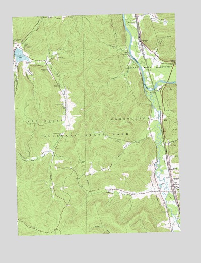
Limestone, NY USGS Topographic Map
Click on map above to begin viewing in our Map Viewer.

This topographic map contains these locations and features:
Feature Name Type Latitude Longitude GNIS ID View Map
Bailley BrookStreamN42.0515°W78.6384°942804View Map
Beehunter CreekStreamN42.0992°W78.7384°943543View Map
Bova CreekStreamN42.0981°W78.7239°944502View Map
Bova Ski TowLocaleN42.1012°W78.7161°974324View Map
Bradford JunctionPopulated PlaceN42.0970°W78.6261°972254View Map
Camp ArrowheadLocaleN42.0578°W78.7150°945544View Map
Camp CarletonLocaleN42.0748°W78.7136°945560View Map
Camp Number EightLocaleN42.1028°W78.7161°945634View Map
Camp Number ElevenLocaleN42.0992°W78.7223°945629View Map
CarrolltonPopulated PlaceN42.1084°W78.6517°945913View Map
Carrollton RunStreamN42.0987°W78.6581°945914View Map
Cattaraugus Residential CenterBuildingN42.0247°W78.6318°2597451View Map
Congdon TrailLocaleN42.0948°W78.7239°947275View Map
France BrookStreamN42.0517°W78.7192°950585View Map
Irish BrookStreamN42.0512°W78.6600°953755View Map
Irvine MillsPopulated PlaceN42.0648°W78.6370°953795View Map
Leonard BrookStreamN42.0509°W78.6392°955212View Map
Leonard RunStreamN42.1045°W78.6614°955216View Map
LimestonePopulated PlaceN42.0273°W78.6295°955350View Map
Limestone BrookStreamN42.0295°W78.6397°955351View Map
Limestone CemeteryCemeteryN42.0366°W78.6339°2554931View Map
Limestone Census Designated PlaceCensusN42.0228°W78.6325°2678893View Map
Limestone Drive-In (historical)LocaleN42.0428°W78.6294°2558461View Map
Limestone Elementary SchoolSchoolN42.0281°W78.6288°2597376View Map
Limestone United Methodist ChurchChurchN42.0224°W78.6285°2597424View Map
Limestone Volunteer Fire Department Station 1BuildingN42.0264°W78.6288°2701144View Map
Limestone Volunteer Fire Department Station 2BuildingN42.0262°W78.6413°2701213View Map
Lony HollowValleyN42.0363°W78.6299°955952View Map
McIntosh CreekStreamN42.1059°W78.7445°956784View Map
McIntosh TrailLocaleN42.1076°W78.7411°956785View Map
Miller HollowValleyN42.1012°W78.6425°957315View Map
Mount IrvineSummitN42.0628°W78.6675°953796View Map
Nichols RunStreamN42.0273°W78.6336°958568View Map
Pentecostal TabernacleChurchN42.0221°W78.6573°2597430View Map
Red House LakeLakeN42.1028°W78.7446°962301View Map
Rice BrookStreamN42.0612°W78.6411°962445View Map
Riverside JunctionPopulated PlaceN42.0809°W78.6417°973009View Map
Ryan TrailLocaleN42.0856°W78.7150°963137View Map
Saint Patrick's ChurchChurchN42.0252°W78.6262°2597443View Map
South CarrolltonPopulated PlaceN42.1031°W78.6620°973091View Map
State Line BrookStreamN42.0056°W78.6272°966273View Map
Stoddard CreekStreamN42.0995°W78.7473°970662View Map
Stoddard HollowValleyN42.0984°W78.7467°966482View Map
Sugar Bush TrailLocaleN42.1112°W78.7492°966703View Map
Thunder RocksPillarN42.0415°W78.7009°967482View Map
Town of CarrolltonCivilN42.0545°W78.6394°978797View Map
Tunungwant CreekStreamN42.0837°W78.6500°967946View Map
Village of Limestone (historical)CivilN42.0228°W78.6325°2390942View Map
Windfall CreekStreamN42.1217°W78.6636°971455View Map
Windfall HollowValleyN42.1231°W78.6486°971458View Map

Note: Coordinates in the location and feature list above are referenced to NAD83 datum.


Copyright (C) 2008-2024 Ryan Niemi / Sunset Dynamics ... All Rights Reserved