TopoQuest Logo
Do you find TopoQuest useful?
Help keep TopoQuest running and adding new maps/features by donating!
Bitcoin:  19c7KJd3qBynnjoSw5npx9KScwjBe4ifkT
Litecoin:  LXs6TkuXGGXo1vDsWCkWVdjQX94eUKd6ui
Home View Maps Find Maps Find Places Resources & Links


Little Valley, New York Topographic Map

USGS Map Title: Little Valley, NY
USGS Map MRC: 42078B7
DRG (GeoTIFF) Download: o42078b7.tif


Neighboring USGS Topographic Map Quads:


  New Albion, NY  
42078C8
 

  Cattaraugus, NY  
42078C7
 

  Ellicottville, NY  
42078C6
 

  Randolph, NY  
42078B8
 

  Little Valley, NY  
42078B7
 

  Salamanca, NY  
42078B6
 

  Steamburg, NY  
42078A8
 

  Red House, NY  
42078A7
 

  Limestone, NY  
42078A6


Map MRC Location:

N43°
W79°
N43°
W78°
H8 H7 H6 H5 H4 H3 H2 H1
G8 G7 G6 G5 G4 G3 G2 G1
F8 F7 F6 F5 F4 F3 F2 F1
E8 E7 E6 E5 E4 E3 E2 E1
D8 D7 D6 D5 D4 D3 D2 D1
C8 C7 C6 C5 C4 C3 C2 C1
B8 B7 B6 B5 B4 B3 B2 B1
A8 A7 A6 A5 A4 A3 A2 A1
N42°
W79°
N42°
W78°

Little Valley, NY USGS 1:24K Topographic Map Preview:
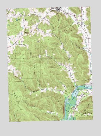
Little Valley, NY USGS Topographic Map
Click on map above to begin viewing in our Map Viewer.

This topographic map contains these locations and features:
Feature Name Type Latitude Longitude GNIS ID View Map
Allegany Indian Reservation Fire DepartmentBuildingN42.1529°W78.7639°2701133View Map
Annis CemeteryCemeteryN42.2325°W78.7680°2554920View Map
Bailey HollowValleyN42.1605°W78.8258°942788View Map
Breeds RunStreamN42.1412°W78.7773°944679View Map
Bucktooth HillSummitN42.1959°W78.7678°945088View Map
Bucktooth IslandIslandN42.1592°W78.7731°945089View Map
Bucktooth RapidsRapidsN42.1601°W78.7725°945090View Map
Bucktooth RunStreamN42.1617°W78.7723°945091View Map
Camp LiloliLocaleN42.1348°W78.8128°945616View Map
Drakes RunStreamN42.1492°W78.7895°948634View Map
Dublin CreekStreamN42.2281°W78.7620°948724View Map
Dublin HollowValleyN42.2146°W78.7548°948725View Map
East Branch Bucktooth RunStreamN42.1792°W78.7836°948990View Map
ElkdalePopulated PlaceN42.2151°W78.7536°949500View Map
First Congregational ChurchChurchN42.2477°W78.7965°2597410View Map
Full Gospel MissionChurchN42.1381°W78.7795°950775View Map
Hillside AcresLocaleN42.2067°W78.8694°2544019View Map
Hoags FlatFlatN42.1556°W78.7742°952908View Map
Jimmerson HillSummitN42.1501°W78.8209°954030View Map
Jimmersontown ChurchChurchN42.1523°W78.7725°954031View Map
Lees HollowValleyN42.2329°W78.7756°955172View Map
Little Valley Campus Elementary SchoolSchoolN42.2478°W78.7971°2597377View Map
Little Valley Post OfficePost OfficeN42.2495°W78.7979°2598456View Map
Little Valley Rod and Gun ClubLocaleN42.2373°W78.8592°974699View Map
Little Valley Volunteer Fire DepartmentBuildingN42.2489°W78.7970°2700874View Map
Maple Grove CemeteryCemeteryN42.2188°W78.8552°956402View Map
Memorial Library of Little ValleyBuildingN42.2490°W78.7977°2598256View Map
Missionary Indian ChurchChurchN42.1328°W78.7850°957440View Map
Newtons EddyBayN42.1617°W78.7545°958529View Map
Parker HillSummitN42.1601°W78.8639°959907View Map
Saint Michaels Lutheran ChurchChurchN42.2485°W78.7980°2597442View Map
Sawmill RunStreamN42.1434°W78.7900°964536View Map
ShongoPopulated PlaceN42.1387°W78.7781°973064View Map
Shutts HillSummitN42.2128°W78.8278°965199View Map
The NarrowsGapN42.2228°W78.8459°967301View Map
Town of ColdspringCivilN42.1431°W78.8556°978850View Map
Town of Little ValleyCivilN42.2265°W78.7613°979159View Map
Town of SalamancaCivilN42.1701°W78.8014°979451View Map
Valley View Baptist ChurchChurchN42.2426°W78.7769°2597449View Map
Village of Little ValleyCivilN42.2494°W78.7988°2390945View Map
West Branch Bucktooth RunStreamN42.1792°W78.7836°969108View Map
Whig Street CreekStreamN42.2148°W78.7584°971037View Map
Woodworth HollowValleyN42.2037°W78.7614°971733View Map

Note: Coordinates in the location and feature list above are referenced to NAD83 datum.


Copyright (C) 2008-2024 Ryan Niemi / Sunset Dynamics ... All Rights Reserved