TopoQuest Logo
Do you find TopoQuest useful?
Help keep TopoQuest running and adding new maps/features by donating!
Bitcoin:  19c7KJd3qBynnjoSw5npx9KScwjBe4ifkT
Litecoin:  LXs6TkuXGGXo1vDsWCkWVdjQX94eUKd6ui
Home View Maps Find Maps Find Places Resources & Links


Lincolnton, Georgia Topographic Map

USGS Map Title: Lincolnton, GA
USGS Map MRC: 33082G4
DRG (GeoTIFF) Download: o33082g4.tif


Neighboring USGS Topographic Map Quads:


  Chennault, GA  
33082H5
 

  Willington, SC  
33082H4
 

  McCormick, SC  
33082H3
 

  Metasville, GA  
33082G5
 

  Lincolnton, GA  
33082G4
 

  Plum Branch, SC  
33082G3
 

  Aonia, GA  
33082F5
 

  Woodlawn, GA  
33082F4
 

  Leah, GA  
33082F3


Map MRC Location:

N34°
W83°
N34°
W82°
H8 H7 H6 H5 H4 H3 H2 H1
G8 G7 G6 G5 G4 G3 G2 G1
F8 F7 F6 F5 F4 F3 F2 F1
E8 E7 E6 E5 E4 E3 E2 E1
D8 D7 D6 D5 D4 D3 D2 D1
C8 C7 C6 C5 C4 C3 C2 C1
B8 B7 B6 B5 B4 B3 B2 B1
A8 A7 A6 A5 A4 A3 A2 A1
N33°
W83°
N33°
W82°

Lincolnton, GA USGS 1:24K Topographic Map Preview:
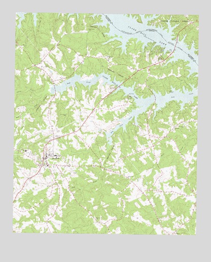
Lincolnton, GA USGS Topographic Map
Click on map above to begin viewing in our Map Viewer.

This topographic map contains these locations and features:
Feature Name Type Latitude Longitude GNIS ID View Map
Augusta CampLocaleN33.8315°W82.3940°326978View Map
Barksdale Ferry (historical)CrossingN33.8723°W82.4368°1252039View Map
Barksdale Ferry (historical)CrossingN33.8723°W82.4368°352092View Map
Bethany ChurchChurchN33.8510°W82.4362°354579View Map
City of LincolntonCivilN33.7931°W82.4777°2404932View Map
Curry CreekStreamN33.8307°W82.4782°355411View Map
Dooley SpringSpringN33.8507°W82.4010°327666View Map
Dry Fork CreekStreamN33.8226°W82.4110°327698View Map
Elijah Clark MonumentParkN33.8546°W82.4026°335574View Map
Elijah Clark State ParkParkN33.8540°W82.4035°355668View Map
Florence CreekStreamN33.8173°W82.4924°327852View Map
Fortson Ferry BridgeBridgeN33.8571°W82.3907°1229196View Map
Fortsons Ferry (historical)CrossingN33.8571°W82.3907°1252045View Map
Fortsons Ferry (historical)CrossingN33.8571°W82.3907°352093View Map
Fortsons Ferry BridgeBridgeN33.8571°W82.3907°352094View Map
LeverettPopulated PlaceN33.8107°W82.3910°332207View Map
Lincoln CountyCivilN33.7937°W82.4512°1688000View Map
Lincoln County CourthouseBuildingN33.7935°W82.4774°335580View Map
Lincoln County Elementary SchoolSchoolN33.7967°W82.4916°335581View Map
Lincoln County High SchoolSchoolN33.7943°W82.4703°335582View Map
Lincoln County JailBuildingN33.7942°W82.4756°2734203View Map
Lincoln County Middle SchoolSchoolN33.7943°W82.4717°2545807View Map
Lincoln County Sheriff's DepartmentBuildingN33.7942°W82.4759°2733727View Map
LincolntonPopulated PlaceN33.7923°W82.4790°328514View Map
Lincolnton Academy (historical)SchoolN33.7893°W82.4804°335583View Map
Lincolnton CemeteryCemeteryN33.7896°W82.4804°335584View Map
Lincolnton Police DepartmentBuildingN33.7929°W82.4777°2733802View Map
Lincolnton Post OfficePost OfficeN33.7884°W82.4774°2767396View Map
Lincolnton Presbyterian ChurchChurchN33.7901°W82.4801°335585View Map
Lincolnton Volunteer Fire DepartmentBuildingN33.7939°W82.4778°2604476View Map
Lincolnton WaterworksLocaleN33.8323°W82.4321°344272View Map
Marthas Chapel School (historical)SchoolN33.8715°W82.3807°1229225View Map
Martins Crossroad Volunteer Fire Department Station 2BuildingN33.8429°W82.4093°2604495View Map
New Hope Baptist ChurchChurchN33.7518°W82.3882°335590View Map
New Prater Ranch Airport (historical)AirportN33.8696°W82.4601°344083View Map
Pine Grove ChurchChurchN33.8118°W82.3837°329214View Map
Pleasant Grove ChurchChurchN33.7821°W82.4221°329254View Map
Prater Ranch AirportAirportN33.8443°W82.4797°344084View Map
Price Grove ChurchChurchN33.8171°W82.4646°329325View Map
Sandy Branch Volunteer Fire DepartmentBuildingN33.8706°W82.3764°2578514View Map
Smith ChapelChurchN33.8654°W82.4487°335597View Map
Smith Chapel CemeteryCemeteryN33.8648°W82.4501°329735View Map
Soap Creek LodgeLocaleN33.8282°W82.4212°329752View Map
White Rock (historical)Populated PlaceN33.7565°W82.4407°344087View Map
White Rock ChurchChurchN33.7587°W82.4432°330251View Map
Willow Landing (historical)LocaleN33.8601°W82.3960°1252061View Map

Note: Coordinates in the location and feature list above are referenced to NAD83 datum.


Copyright (C) 2008-2025 Ryan Niemi / Sunset Dynamics ... All Rights Reserved