TopoQuest Logo
Do you find TopoQuest useful?
Help keep TopoQuest running and adding new maps/features by donating!
Bitcoin:  19c7KJd3qBynnjoSw5npx9KScwjBe4ifkT
Litecoin:  LXs6TkuXGGXo1vDsWCkWVdjQX94eUKd6ui
Home View Maps Find Maps Find Places Resources & Links


Plum Branch, South Carolina Topographic Map

USGS Map Title: Plum Branch, SC
USGS Map MRC: 33082G3
DRG (GeoTIFF) Download: o33082g3.tif


Neighboring USGS Topographic Map Quads:


  Willington, SC  
33082H4
 

  McCormick, SC  
33082H3
 

  Winterseat, SC  
33082H2
 

  Lincolnton, GA  
33082G4
 

  Plum Branch, SC  
33082G3
 

  Parksville, SC  
33082G2
 

  Woodlawn, GA  
33082F4
 

  Leah, GA  
33082F3
 

  Clarks Hill, SC  
33082F2


Map MRC Location:

N34°
W83°
N34°
W82°
H8 H7 H6 H5 H4 H3 H2 H1
G8 G7 G6 G5 G4 G3 G2 G1
F8 F7 F6 F5 F4 F3 F2 F1
E8 E7 E6 E5 E4 E3 E2 E1
D8 D7 D6 D5 D4 D3 D2 D1
C8 C7 C6 C5 C4 C3 C2 C1
B8 B7 B6 B5 B4 B3 B2 B1
A8 A7 A6 A5 A4 A3 A2 A1
N33°
W83°
N33°
W82°

Plum Branch, SC USGS 1:24K Topographic Map Preview:
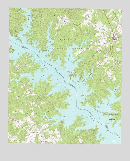
Plum Branch, SC USGS Topographic Map
Click on map above to begin viewing in our Map Viewer.

This topographic map contains these locations and features:
Feature Name Type Latitude Longitude GNIS ID View Map
Benningsfield CreekStreamN33.8165°W82.3123°1246744View Map
Branch School (historical)SchoolN33.8021°W82.2710°1229181View Map
Camp CreekStreamN33.7724°W82.2782°344079View Map
Camp Daniel MarshallLocaleN33.7632°W82.2840°354967View Map
Chamberlain Ferry Picnic AreaParkN33.8462°W82.3510°1229189View Map
Chamberlains Ferry (historical)CrossingN33.8376°W82.3554°1229190View Map
Chamberlains Ferry (historical)CrossingN33.8376°W82.3554°335572View Map
Clark Hill MarinaLocaleN33.8165°W82.3051°1229560View Map
Dordon CreekStreamN33.7782°W82.2732°1229644View Map
Double BranchesPopulated PlaceN33.7521°W82.3329°331576View Map
Ferguson Island (historical)IslandN33.8057°W82.3123°344080View Map
Geyer Springs School (historical)SchoolN33.8726°W82.3096°1229198View Map
Hawe CreekStreamN33.8307°W82.3373°1229781View Map
Hawe Creek Camping AreaLocaleN33.8362°W82.3385°1245923View Map
Holiness ChurchChurchN33.7715°W82.3723°335579View Map
Jester BranchStreamN33.8521°W82.3221°1229857View Map
Landam BranchStreamN33.8060°W82.2946°1229894View Map
Little RiverStreamN33.8421°W82.3571°1229933View Map
Little River SubdivisionPopulated PlaceN33.8501°W82.3671°1229218View Map
Marthas Chapel (historical)ChurchN33.8657°W82.3737°1229224View Map
Martin Island (historical)IslandN33.7579°W82.2573°344081View Map
Martins Crossroad Volunteer Fire DepartmentBuildingN33.7672°W82.3620°2603768View Map
Martins CrossroadsPopulated PlaceN33.7723°W82.3718°326388View Map
MaximPopulated PlaceN33.7932°W82.3407°332335View Map
McCoys Ferry (historical)CrossingN33.8165°W82.3218°1251640View Map
McCoys Ferry (historical)CrossingN33.8165°W82.3218°335588View Map
Mulberry ChurchChurchN33.7510°W82.3296°335589View Map
New Hope ChurchChurchN33.8748°W82.2501°1229244View Map
Parks Grove ChurchChurchN33.8146°W82.3640°320241View Map
Pine Grove CemeteryCemeteryN33.8237°W82.2871°1250095View Map
Pine Grove ChurchChurchN33.8301°W82.2671°1250102View Map
Pine Grove Church (historical)ChurchN33.8237°W82.2879°1229256View Map
Pine Grove School (historical)SchoolN33.8235°W82.2879°1229257View Map
Plum BranchPopulated PlaceN33.8487°W82.2598°1230184View Map
Plum Branch Baptist ChurchChurchN33.8501°W82.2579°1229260View Map
Plum Branch CemeteryCemeteryN33.8515°W82.2529°1229261View Map
Plum Branch Volunteer Fire DepartmentBuildingN33.8495°W82.2603°2578505View Map
Republican CemeteryCemeteryN33.8619°W82.3412°1229264View Map
Republican ChurchChurchN33.8621°W82.3412°1250349View Map
Searle Island (historical)IslandN33.7771°W82.2865°344086View Map
Searle Mill (historical)LocaleN33.8698°W82.3540°1241319View Map
Searles School (historical)SchoolN33.8587°W82.2998°1252057View Map
Shriver CreekStreamN33.7796°W82.3035°322966View Map
Soap CreekStreamN33.8354°W82.3621°329751View Map
Springfield ChurchChurchN33.8651°W82.3387°1230359View Map
Springfield School (historical)SchoolN33.8651°W82.3393°1229276View Map
Sturkeys Ferry (historical)CrossingN33.8015°W82.3010°1229277View Map
Sturkeys Ferry (historical)CrossingN33.8015°W82.3010°352098View Map
Town of Plum BranchCivilN33.8482°W82.2587°2407137View Map
Wallace Landing (historical)LocaleN33.7793°W82.2840°1252060View Map
Wells CreekStreamN33.8151°W82.3335°330202View Map

Note: Coordinates in the location and feature list above are referenced to NAD83 datum.


Copyright (C) 2008-2025 Ryan Niemi / Sunset Dynamics ... All Rights Reserved