TopoQuest Logo
Do you find TopoQuest useful?
Help keep TopoQuest running and adding new maps/features by donating!
Bitcoin:  19c7KJd3qBynnjoSw5npx9KScwjBe4ifkT
Litecoin:  LXs6TkuXGGXo1vDsWCkWVdjQX94eUKd6ui
Home View Maps Find Maps Find Places Resources & Links


Litchfield, Michigan Topographic Map

USGS Map Title: Litchfield, MI
USGS Map MRC: 42084A7
DRG (GeoTIFF) Download: o42084a7.tif


Neighboring USGS Topographic Map Quads:


  Lyon Lake, MI  
42084B8
 

  Southwest Albion, MI  
42084B7
 

  Southeast Albion, MI  
42084B6
 

  Tekonsha, MI  
42084A8
 

  Litchfield, MI  
42084A7
 

  Mosherville, MI  
42084A6
 

  Coldwater East, MI  
41084H8
 

  Allen, MI  
41084H7
 

  Hillsdale, MI  
41084H6


Map MRC Location:

N43°
W85°
N43°
W84°
H8 H7 H6 H5 H4 H3 H2 H1
G8 G7 G6 G5 G4 G3 G2 G1
F8 F7 F6 F5 F4 F3 F2 F1
E8 E7 E6 E5 E4 E3 E2 E1
D8 D7 D6 D5 D4 D3 D2 D1
C8 C7 C6 C5 C4 C3 C2 C1
B8 B7 B6 B5 B4 B3 B2 B1
A8 A7 A6 A5 A4 A3 A2 A1
N42°
W85°
N42°
W84°

Litchfield, MI USGS 1:24K Topographic Map Preview:
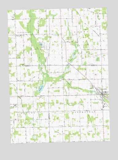
Litchfield, MI USGS Topographic Map
Click on map above to begin viewing in our Map Viewer.

This topographic map contains these locations and features:
Feature Name Type Latitude Longitude GNIS ID View Map
Bentleys CornersPopulated PlaceN42.1023°W84.8666°621133View Map
Boot Hill CemeteryCemeteryN42.0383°W84.8647°2435440View Map
Born SchoolSchoolN42.1084°W84.8650°621746View Map
Boughton SchoolSchoolN42.1156°W84.8077°621772View Map
ButlerPopulated PlaceN42.0578°W84.8652°622363View Map
Butler CemeteryCemeteryN42.0583°W84.8556°2435442View Map
Butler Post Office (historical)Post OfficeN42.0578°W84.8653°2435384View Map
Butler SpeedwayLocaleN42.0347°W84.8667°2109257View Map
City of LitchfieldCivilN42.0418°W84.7581°1626628View Map
Clarendon CemeteryCemeteryN42.1011°W84.8561°623342View Map
Clarendon Township ParkParkN42.1181°W84.8667°2109310View Map
Claucherty AirportAirportN42.0777°W84.8271°1624011View Map
Congregational ChurchChurchN42.0458°W84.7581°2418485View Map
Congregational Church of Litchfield Historical MarkerParkN42.0453°W84.7583°2419769View Map
Fireman's ParkParkN42.0433°W84.7589°2418490View Map
First Baptist ChurchChurchN42.0444°W84.7583°2418484View Map
Frier LakeLakeN42.0923°W84.8338°626502View Map
Hadley Corners SchoolSchoolN42.0287°W84.8077°627585View Map
Herricksuille SchoolSchoolN42.0581°W84.8700°628143View Map
Jenkins Golf CourseLocaleN42.0500°W84.7731°2109933View Map
Knicker Bocker SchoolSchoolN42.0798°W84.8700°629814View Map
Lampson Run DrainCanalN42.1048°W84.7697°630116View Map
LitchfieldPopulated PlaceN42.0439°W84.7575°630540View Map
Litchfield Elementary SchoolSchoolN42.0461°W84.7578°2418488View Map
Litchfield Family Health ClinicHospitalN42.0492°W84.7581°2418483View Map
Litchfield Fire DepartmentBuildingN42.0433°W84.7575°2418482View Map
Litchfield High SchoolSchoolN42.0461°W84.7544°2418489View Map
Litchfield LibraryBuildingN42.0456°W84.7586°2418480View Map
Litchfield Police DeptBuildingN42.0431°W84.7576°2418481View Map
Litchfield Post OfficePost OfficeN42.0431°W84.7583°2418473View Map
Litchfield StationLocaleN42.0453°W84.7639°2418487View Map
Litchfield Village CemeteryCemeteryN42.0433°W84.7533°2419742View Map
McIlwain and Extension DrainCanalN42.0917°W84.7808°2109307View Map
Oak Arbor SchoolSchoolN42.0139°W84.7514°633810View Map
Quaker LakeLakeN42.0509°W84.8356°635541View Map
Quaker Mills SchoolSchoolN42.0723°W84.8191°635542View Map
Rainey SchoolSchoolN42.0720°W84.7977°635605View Map
Reading Emergency Unit Station #3BuildingN42.0427°W84.7572°2662075View Map
Saint Joe Baptist ChurchChurchN42.1019°W84.8681°2630092View Map
Saint Joseph CemeteryCemeteryN42.0728°W84.8575°2109309View Map
Saint Joseph ChurchChurchN42.0725°W84.8569°636775View Map
Sand CreekStreamN42.0567°W84.8033°637172View Map
Saratoga CemeteryCemeteryN42.0586°W84.7978°2109934View Map
Shooks Prairie CemeteryCemeteryN42.0003°W84.8561°637838View Map
Soap CreekStreamN42.0759°W84.8350°638225View Map
South Litchfield ChurchChurchN42.0150°W84.8089°638380View Map
Stoddard SchoolSchoolN42.0575°W84.7569°638859View Map
Township of HomerCivilN42.1152°W84.7683°1626485View Map
Township of LitchfieldCivilN42.0274°W84.7689°1626629View Map
United Methodist ChurchChurchN42.0458°W84.7594°2418486View Map
Whig Center CemeteryCemeteryN42.0433°W84.8611°2109258View Map
Whig Center SchoolSchoolN42.0420°W84.8644°1616277View Map
Whitcomb LakeLakeN42.0802°W84.7939°1616295View Map
Worthington and Billman DrainCanalN42.1014°W84.7639°2109308View Map

Note: Coordinates in the location and feature list above are referenced to NAD83 datum.


Copyright (C) 2008-2024 Ryan Niemi / Sunset Dynamics ... All Rights Reserved