TopoQuest Logo
Do you find TopoQuest useful?
Help keep TopoQuest running and adding new maps/features by donating!
Bitcoin:  19c7KJd3qBynnjoSw5npx9KScwjBe4ifkT
Litecoin:  LXs6TkuXGGXo1vDsWCkWVdjQX94eUKd6ui
Home View Maps Find Maps Find Places Resources & Links


Lyon Lake, Michigan Topographic Map

USGS Map Title: Lyon Lake, MI
USGS Map MRC: 42084B8
DRG (GeoTIFF) Download: o42084b8.tif


Neighboring USGS Topographic Map Quads:


  Ceresco, MI  
42085C1
 

  Marshall, MI  
42084C8
 

  Northwest Albion, MI  
42084C7
 

  Ellis Corners, MI  
42085B1
 

  Lyon Lake, MI  
42084B8
 

  Southwest Albion, MI  
42084B7
 

  Burlington, MI  
42085A1
 

  Tekonsha, MI  
42084A8
 

  Litchfield, MI  
42084A7


Map MRC Location:

N43°
W85°
N43°
W84°
H8 H7 H6 H5 H4 H3 H2 H1
G8 G7 G6 G5 G4 G3 G2 G1
F8 F7 F6 F5 F4 F3 F2 F1
E8 E7 E6 E5 E4 E3 E2 E1
D8 D7 D6 D5 D4 D3 D2 D1
C8 C7 C6 C5 C4 C3 C2 C1
B8 B7 B6 B5 B4 B3 B2 B1
A8 A7 A6 A5 A4 A3 A2 A1
N42°
W85°
N42°
W84°

Lyon Lake, MI USGS 1:24K Topographic Map Preview:
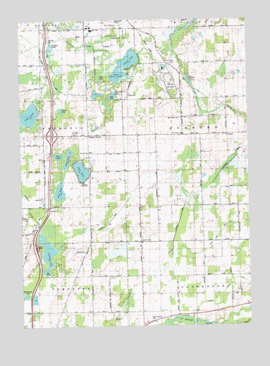
Lyon Lake, MI USGS Topographic Map
Click on map above to begin viewing in our Map Viewer.

This topographic map contains these locations and features:
Feature Name Type Latitude Longitude GNIS ID View Map
Cedar LakeLakeN42.2116°W84.9946°622919View Map
Cedar Lake Post Office (historical)Post OfficeN42.2083°W84.9917°2630175View Map
Clarendon and Eckford Drain Number ThreeCanalN42.1492°W84.8850°623341View Map
Crystal LakeLakeN42.2401°W84.9823°624172View Map
Eaton Proving GroundsLocaleN42.2234°W84.9161°1623330View Map
Fish LakeLakeN42.1800°W84.9787°626033View Map
Fredonia Township Fire Department Station 1BuildingN42.2025°W84.9632°2636189View Map
Goose Pond DrainCanalN42.1667°W84.8872°626983View Map
Huckleberry DrainCanalN42.1973°W84.8783°628757View Map
Interchange 32CrossingN42.2033°W84.9825°2628036View Map
Klingaman LakeLakeN42.1378°W84.9982°629793View Map
Little Polly ChurchChurchN42.2334°W84.9147°630737View Map
Long LakeLakeN42.1940°W84.9741°630920View Map
Lyon LakeLakeN42.1886°W84.9667°631240View Map
Lyon Lake CemeteryCemeteryN42.1964°W84.9611°2630225View Map
Lyon Lake ChurchChurchN42.1959°W84.9625°631242View Map
Lyon Lake Post Office (historical)Post OfficeN42.1947°W84.9625°2630160View Map
Maple Grove ChurchChurchN42.1598°W84.9339°631447View Map
Marshall Country ClubLocaleN42.1837°W84.9655°1623504View Map
Maynard LakeLakeN42.2192°W84.9489°631778View Map
McFadden CemeteryCemeteryN42.1311°W84.9625°2630224View Map
Mud LakeLakeN42.2259°W84.9547°632906View Map
Nottawa DrainCanalN42.1873°W84.9183°633768View Map
Nottawa LakeLakeN42.1541°W84.9853°633769View Map
Pine LakeLakeN42.1948°W84.9795°634955View Map
Squaw LakeLakeN42.2135°W84.9775°638675View Map
Squaw Lake DrainCanalN42.2289°W84.9794°638683View Map
Stuart LakeLakeN42.2338°W84.9396°638974View Map
Township of EckfordCivilN42.2028°W84.8850°1626214View Map
Upper Brace LakeLakeN42.2276°W84.9461°1615396View Map
West Clarendon CemeteryCemeteryN42.1275°W84.9294°1616092View Map
West Eckford CemeteryCemeteryN42.2103°W84.9114°1616101View Map
West Eckford ChurchChurchN42.2037°W84.9108°1616102View Map
Westwinds CampgroundLocaleN42.1556°W84.9658°1616230View Map
Wilders PondLakeN42.2250°W84.9066°1616454View Map
Wilders Station (historical)LocaleN42.2278°W84.9111°2630059View Map
Wilderville Post Office (historical)Post OfficeN42.2278°W84.9111°2630115View Map
Wrights CornersPopulated PlaceN42.2037°W84.9619°1616845View Map

Note: Coordinates in the location and feature list above are referenced to NAD83 datum.


Copyright (C) 2008-2025 Ryan Niemi / Sunset Dynamics ... All Rights Reserved