TopoQuest Logo
Do you find TopoQuest useful?
Help keep TopoQuest running and adding new maps/features by donating!
Bitcoin:  19c7KJd3qBynnjoSw5npx9KScwjBe4ifkT
Litecoin:  LXs6TkuXGGXo1vDsWCkWVdjQX94eUKd6ui
Home View Maps Find Maps Find Places Resources & Links


Littleton, Iowa Topographic Map

USGS Map Title: Littleton, IA
USGS Map MRC: 42092E1
DRG (GeoTIFF) Download: o42092e1.tif


Neighboring USGS Topographic Map Quads:


  Readlyn, IA  
42092F2
 

  Fairbank, IA  
42092F1
 

  Oelwein, IA  
42091F8
 

  Dunkerton, IA  
42092E2
 

  Littleton, IA  
42092E1
 

  Hazleton, IA  
42091E8
 

  Gilbertville, IA  
42092D2
 

  Jesup, IA  
42092D1
 

  Independence, IA  
42091D8


Map MRC Location:

N43°
W93°
N43°
W92°
H8 H7 H6 H5 H4 H3 H2 H1
G8 G7 G6 G5 G4 G3 G2 G1
F8 F7 F6 F5 F4 F3 F2 F1
E8 E7 E6 E5 E4 E3 E2 E1
D8 D7 D6 D5 D4 D3 D2 D1
C8 C7 C6 C5 C4 C3 C2 C1
B8 B7 B6 B5 B4 B3 B2 B1
A8 A7 A6 A5 A4 A3 A2 A1
N42°
W93°
N42°
W92°

Littleton, IA USGS 1:24K Topographic Map Preview:
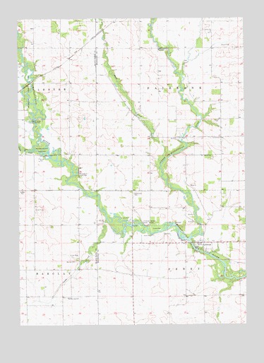
Littleton, IA USGS Topographic Map
Click on map above to begin viewing in our Map Viewer.

This topographic map contains these locations and features:
Feature Name Type Latitude Longitude GNIS ID View Map
Amish CemeteryCemeteryN42.5689°W92.0227°454171View Map
Barclay Post Office (historical)Post OfficeN42.5230°W92.0918°2001913View Map
Brown SchoolSchoolN42.6122°W92.0468°454865View Map
Bruggeman County ParkParkN42.5972°W92.1182°454875View Map
Buck CreekStreamN42.5664°W92.0455°454918View Map
Camp CreekStreamN42.5433°W92.0766°455110View Map
Crane CreekStreamN42.5711°W92.1168°455698View Map
Cutshaw Bridge State Access AreaParkN42.5389°W92.0516°2000171View Map
KierLocaleN42.5980°W92.0032°466240View Map
Kier Post Office (historical)Post OfficeN42.5980°W92.0032°2000067View Map
Little Wapsipinicon RiverStreamN42.5350°W92.0310°458528View Map
LittletonPopulated PlaceN42.5333°W92.0235°458534View Map
Littleton CemeteryCemeteryN42.5339°W92.0179°2000170View Map
Littleton Post Office (historical)Post OfficeN42.5328°W92.0238°2000066View Map
Mickey Fox Wildlife AreaParkN42.5389°W92.0502°2000054View Map
New Barclay CemeteryCemeteryN42.5114°W92.0981°459467View Map
Old Barclay CemeteryCemeteryN42.5258°W92.0935°454355View Map
Rigdon Access County ParkParkN42.5819°W92.1141°460635View Map
River Birch Bottom County ParkParkN42.5714°W92.1096°460648View Map
Rural Elementary School Number 4SchoolN42.6197°W92.0182°455305View Map
Saint Michaels CemeteryCemeteryN42.5533°W92.0616°461228View Map
Township of FairbankCivilN42.5984°W92.0229°467806View Map
Township of PerryCivilN42.5113°W92.0230°468506View Map
Triumph Elementary SchoolSchoolN42.5762°W92.0137°462330View Map
Union CemeteryCemeteryN42.5833°W92.0163°462432View Map
Wapsie Bluff County ParkParkN42.5614°W92.0943°462668View Map

Note: Coordinates in the location and feature list above are referenced to NAD83 datum.


Copyright (C) 2008-2024 Ryan Niemi / Sunset Dynamics ... All Rights Reserved