TopoQuest Logo
Do you find TopoQuest useful?
Help keep TopoQuest running and adding new maps/features by donating!
Bitcoin:  19c7KJd3qBynnjoSw5npx9KScwjBe4ifkT
Litecoin:  LXs6TkuXGGXo1vDsWCkWVdjQX94eUKd6ui
Home View Maps Find Maps Find Places Resources & Links


Lodge Grass, Montana Topographic Map

USGS Map Title: Lodge Grass, MT
USGS Map MRC: 45107C3
DRG (GeoTIFF) Download: o45107c3.tif


Neighboring USGS Topographic Map Quads:


  Benteen, MT  
45107D4
 

  Lodge Grass NE, MT  
45107D3
 

  Thompson Creek NW, MT  
45107D2
 

  Good Luck Creek, MT  
45107C4
 

  Lodge Grass, MT  
45107C3
 

  Wolf Mountain Lookout, MT  
45107C2
 

  Wyola, MT  
45107B4
 

  Wyola NE, MT  
45107B3
 

  Kid Creek, MT  
45107B2


Map MRC Location:

N46°
W108°
N46°
W107°
H8 H7 H6 H5 H4 H3 H2 H1
G8 G7 G6 G5 G4 G3 G2 G1
F8 F7 F6 F5 F4 F3 F2 F1
E8 E7 E6 E5 E4 E3 E2 E1
D8 D7 D6 D5 D4 D3 D2 D1
C8 C7 C6 C5 C4 C3 C2 C1
B8 B7 B6 B5 B4 B3 B2 B1
A8 A7 A6 A5 A4 A3 A2 A1
N45°
W108°
N45°
W107°

Lodge Grass, MT USGS 1:24K Topographic Map Preview:
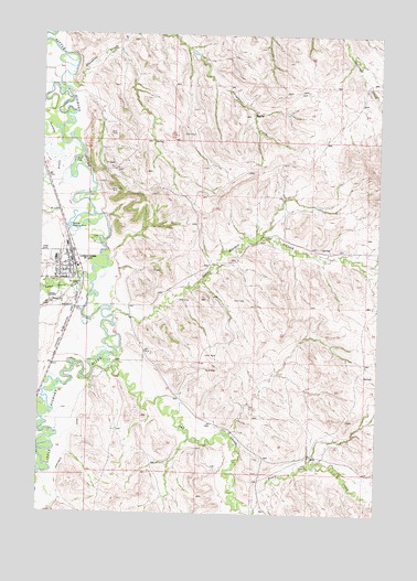
Lodge Grass, MT USGS Topographic Map
Click on map above to begin viewing in our Map Viewer.

This topographic map contains these locations and features:
Feature Name Type Latitude Longitude GNIS ID View Map
0635E25BAAA01_ WellWellN45.2883°W107.3681°808742View Map
06S35E01BCAA01 WellWellN45.3427°W107.3720°809017View Map
06S35E01CABA01 WellWellN45.3394°W107.3720°809006View Map
06S35E01CD__01 WellWellN45.3341°W107.3706°808977View Map
06S35E01DC__01 WellWellN45.3341°W107.3656°808976View Map
06S35E12ACBB01 WellWellN45.3222°W107.3676°808927View Map
06S35E12BDDC01 WellWellN45.3261°W107.3704°808948View Map
06S35E12DD__01 WellWellN45.3197°W107.3606°808908View Map
06S35E13AA__01 WellWellN45.3161°W107.3606°808895View Map
06S35E13AB__01 WellWellN45.3161°W107.3656°808896View Map
06S35E13AC__01 WellWellN45.3125°W107.3656°808869View Map
06S35E13AC__02 WellWellN45.3125°W107.3656°808870View Map
06S35E13AC__03 WellWellN45.3125°W107.3656°808871View Map
06S35E13AC__04 WellWellN45.3125°W107.3656°808872View Map
06S35E13AC__05 WellWellN45.3125°W107.3656°808873View Map
06S35E13ACAC01 WellWellN45.3136°W107.3651°808881View Map
06S35E13ADCC01 WellWellN45.3116°W107.3631°808862View Map
06S35E13BA__01 WellWellN45.3161°W107.3706°808897View Map
06S35E13BABD01 WellWellN45.3164°W107.3718°808900View Map
06S35E13CAAA01 WellWellN45.3108°W107.3693°808857View Map
06S35E13CAAA02 WellWellN45.3105°W107.3698°808855View Map
06S35E13CDAD01 WellWellN45.3064°W107.3681°808835View Map
06S35E13CDCB01 WellWellN45.3047°W107.3740°808827View Map
06S35E13DCBB01 WellWellN45.3061°W107.3684°808833View Map
06S35E24CACD01 WellWellN45.2922°W107.3720°808762View Map
06S35E24CACD02 WellWellN45.2925°W107.3720°808763View Map
06S35E25CDBB01 WellWellN45.2775°W107.3729°808690View Map
06S35E36BCBC01 WellWellN45.2697°W107.3737°808660View Map
06S36E06CBBA01 WellWellN45.3402°W107.3551°809010View Map
06S36E18ACAD01 WellWellN45.3136°W107.3423°808880View Map
06S36E29CDAC01 WellWellN45.2772°W107.3231°808688View Map
06S36E29DCDB01 WellWellN45.2766°W107.3231°808683View Map
06S36E33BACB01 WellWellN45.2730°W107.3109°808675View Map
First Crow Indian Baptist ChurchChurchN45.3144°W107.3631°1716344View Map
Fort C F Smith Historical MarkerParkN45.3111°W107.3673°1716396View Map
Forty Mile ColonyPopulated PlaceN45.2700°W107.3506°1716275View Map
Fortymile CanalCanalN45.2708°W107.3609°771529View Map
Grey Blanket CreekStreamN45.3016°W107.3493°771989View Map
Grey Blanket School (historical)SchoolN45.3122°W107.2845°1716425View Map
Interchange 530CrossingN45.3125°W107.3490°1716387View Map
Lodge GrassPopulated PlaceN45.3144°W107.3631°773532View Map
Lodge GrassLocaleN45.3144°W107.3631°1716511View Map
Lodge Grass CreekStreamN45.3097°W107.3568°773537View Map
Lodge Grass Post OfficePost OfficeN45.3134°W107.3636°1716510View Map
Lodge Grass SchoolSchoolN45.3172°W107.3710°1716436View Map
Lodge Grass Volunteer Fire DepartmentBuildingN45.3137°W107.3654°2546713View Map
Our Lady of Loretto ChurchChurchN45.3144°W107.3631°1716343View Map
Owl CreekStreamN45.2891°W107.3501°775009View Map
Sioux Pass CreekStreamN45.2519°W107.2951°776579View Map
Slaughter CreekStreamN45.3637°W107.3666°776629View Map
Sunday CreekStreamN45.3505°W107.3706°777320View Map
Town of Lodge GrassCivilN45.3143°W107.3678°2412909View Map
White Arm ParkParkN45.3119°W107.3626°1716329View Map

Note: Coordinates in the location and feature list above are referenced to NAD83 datum.


Copyright (C) 2008-2024 Ryan Niemi / Sunset Dynamics ... All Rights Reserved