TopoQuest Logo
Do you find TopoQuest useful?
Help keep TopoQuest running and adding new maps/features by donating!
Bitcoin:  19c7KJd3qBynnjoSw5npx9KScwjBe4ifkT
Litecoin:  LXs6TkuXGGXo1vDsWCkWVdjQX94eUKd6ui
Home View Maps Find Maps Find Places Resources & Links


Lometa, Texas Topographic Map

USGS Map Title: Lometa, TX
USGS Map MRC: 31098B4
DRG (GeoTIFF) Download: o31098b4.tif


Neighboring USGS Topographic Map Quads:


  San Saba Peak, TX  
31098C5
 

  Antelope Gap, TX  
31098C4
 

  Castle Peak, TX  
31098C3
 

  Wolf Ridge, TX  
31098B5
 

  Lometa, TX  
31098B4
 

  Ogles, TX  
31098B3
 

  Bend, TX  
31098A5
 

  Gorman Falls, TX  
31098A4
 

  Nix, TX  
31098A3


Map MRC Location:

N32°
W99°
N32°
W98°
H8 H7 H6 H5 H4 H3 H2 H1
G8 G7 G6 G5 G4 G3 G2 G1
F8 F7 F6 F5 F4 F3 F2 F1
E8 E7 E6 E5 E4 E3 E2 E1
D8 D7 D6 D5 D4 D3 D2 D1
C8 C7 C6 C5 C4 C3 C2 C1
B8 B7 B6 B5 B4 B3 B2 B1
A8 A7 A6 A5 A4 A3 A2 A1
N31°
W99°
N31°
W98°

Lometa, TX USGS 1:24K Topographic Map Preview:
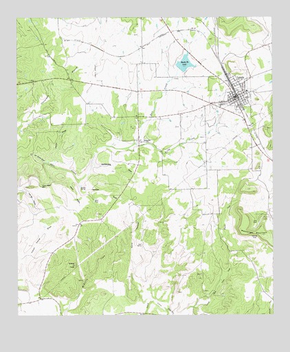
Lometa, TX USGS Topographic Map
Click on map above to begin viewing in our Map Viewer.

This topographic map contains these locations and features:
Feature Name Type Latitude Longitude GNIS ID View Map
Browns CreekStreamN31.1274°W98.4278°1352997View Map
City of LometaCivilN31.2166°W98.3924°2410858View Map
Denmoe CoveBasinN31.1574°W98.3856°1355916View Map
Dugout CreekStreamN31.1502°W98.3959°1356417View Map
Grassy KnobSummitN31.1463°W98.4717°1358312View Map
Happy HollowValleyN31.1812°W98.4836°1358752View Map
Indian Camp DrawValleyN31.1476°W98.4984°1359917View Map
Indian Water HoleLakeN31.1796°W98.4886°1359996View Map
Jennings SpringsSpringN31.1752°W98.4670°1998376View Map
Kirby CreekStreamN31.1971°W98.4417°1360694View Map
LometaPopulated PlaceN31.2171°W98.3934°1361632View Map
Lometa Air StripAirportN31.2255°W98.4613°1387099View Map
Lometa City HallBuildingN31.2173°W98.3939°2753747View Map
Lometa DivisionCivilN31.2109°W98.4004°1938932View Map
Lometa Post OfficePost OfficeN31.2184°W98.3939°2731813View Map
Lometa ReservoirReservoirN31.2302°W98.4189°1856179View Map
Lometa Reservoir DamDamN31.2285°W98.4203°1856178View Map
Lometa SchoolSchoolN31.2191°W98.3889°2007959View Map
Lometa Volunteer Fire and Rescue DepartmentBuildingN31.2173°W98.3940°2552081View Map
Long Cove CemeteryCemeteryN31.2171°W98.3934°2507787View Map
Lost SpringSpringN31.1545°W98.4395°1361845View Map
Lynn CoveValleyN31.1681°W98.3841°1362004View Map
Messanger MountainSummitN31.1588°W98.3809°1362664View Map
North Fork Lynch CreekStreamN31.1252°W98.4234°1375170View Map
Panther DrawValleyN31.1816°W98.4702°1364785View Map
Panther SpringSpringN31.1785°W98.4689°1364794View Map
Pecan DrawValleyN31.1885°W98.4831°1364972View Map
Pole Bar CanyonValleyN31.1785°W98.4982°1365514View Map
Rattlesnake DrawValleyN31.1892°W98.4636°1366037View Map
Sand HollowValleyN31.1454°W98.4428°1367615View Map
Sand TankReservoirN31.1732°W98.4627°1367646View Map
Santa Fe LakeReservoirN31.2288°W98.4195°1367748View Map
SenterfittPopulated PlaceN31.1979°W98.4373°1380514View Map
Senterfitt (historical)Populated PlaceN31.2002°W98.4428°2034970View Map
Van Winkle GulchValleyN31.1890°W98.4869°1370581View Map

Note: Coordinates in the location and feature list above are referenced to NAD83 datum.


Copyright (C) 2008-2024 Ryan Niemi / Sunset Dynamics ... All Rights Reserved