TopoQuest Logo
Do you find TopoQuest useful?
Help keep TopoQuest running and adding new maps/features by donating!
Bitcoin:  19c7KJd3qBynnjoSw5npx9KScwjBe4ifkT
Litecoin:  LXs6TkuXGGXo1vDsWCkWVdjQX94eUKd6ui
Home View Maps Find Maps Find Places Resources & Links


Wolf Ridge, Texas Topographic Map

USGS Map Title: Wolf Ridge, TX
USGS Map MRC: 31098B5
DRG (GeoTIFF) Download: o31098b5.tif


Neighboring USGS Topographic Map Quads:


  Big Valley South, TX  
31098C6
 

  San Saba Peak, TX  
31098C5
 

  Antelope Gap, TX  
31098C4
 

  San Saba, TX  
31098B6
 

  Wolf Ridge, TX  
31098B5
 

  Lometa, TX  
31098B4
 

  Bear Hollow, TX  
31098A6
 

  Bend, TX  
31098A5
 

  Gorman Falls, TX  
31098A4


Map MRC Location:

N32°
W99°
N32°
W98°
H8 H7 H6 H5 H4 H3 H2 H1
G8 G7 G6 G5 G4 G3 G2 G1
F8 F7 F6 F5 F4 F3 F2 F1
E8 E7 E6 E5 E4 E3 E2 E1
D8 D7 D6 D5 D4 D3 D2 D1
C8 C7 C6 C5 C4 C3 C2 C1
B8 B7 B6 B5 B4 B3 B2 B1
A8 A7 A6 A5 A4 A3 A2 A1
N31°
W99°
N31°
W98°

Wolf Ridge, TX USGS 1:24K Topographic Map Preview:
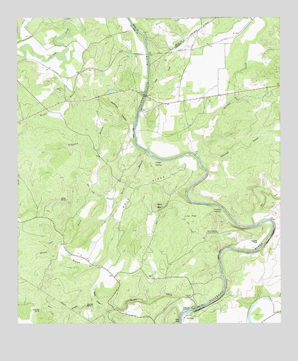
Wolf Ridge, TX USGS Topographic Map
Click on map above to begin viewing in our Map Viewer.

This topographic map contains these locations and features:
Feature Name Type Latitude Longitude GNIS ID View Map
Antelope CreekStreamN31.1929°W98.5392°1351142View Map
Blue Pool SpringSpringN31.1321°W98.5928°1352484View Map
Boggy CreekStreamN31.2238°W98.5623°1352575View Map
Browns BranchStreamN31.2382°W98.6006°1352993View Map
Burnt BranchStreamN31.1941°W98.5628°1353364View Map
Cedar BranchStreamN31.1671°W98.5837°1354037View Map
Cedar HollowBasinN31.1902°W98.5578°1354109View Map
Colony ChurchChurchN31.1443°W98.5617°1354812View Map
Cottonwood BranchStreamN31.1946°W98.5370°1355054View Map
Elliott CreekStreamN31.2474°W98.5695°1356922View Map
Glory HoleLakeN31.1263°W98.5481°1373858View Map
Harmony Ridge CemeteryCemeteryN31.2424°W98.5808°2570563View Map
Harris CemeteryCemeteryN31.2213°W98.6039°1358844View Map
Hicks CrossingPopulated PlaceN31.1671°W98.5056°1379927View Map
Historical MonumentParkN31.1618°W98.5353°1359309View Map
Lick FlatFlatN31.1679°W98.5428°1361178View Map
Lost BranchStreamN31.1763°W98.5442°1361810View Map
Molasses HollowValleyN31.2061°W98.5695°1363040View Map
Parker SpringsSpringN31.1252°W98.5753°1998377View Map
Parks MillLocaleN31.1357°W98.5439°1364847View Map
Pecan Pool SpringSpringN31.1304°W98.6150°1364981View Map
Pool BranchStreamN31.1288°W98.5828°1365572View Map
Rabbit HollowValleyN31.1329°W98.5816°1365932View Map
Raven BluffCliffN31.1532°W98.5292°1366060View Map
Raven CliffCliffN31.1599°W98.5050°1366061View Map
Red BluffCliffN31.2029°W98.5695°1366116View Map
Red Bluff CrossingPopulated PlaceN31.2124°W98.5664°1380418View Map
Robinson RanchLocaleN31.1582°W98.5139°1366622View Map
Rock Lick BranchStreamN31.1796°W98.5759°1366684View Map
Rough CreekStreamN31.1307°W98.5434°1366912View Map
Rough Creek CrossingPopulated PlaceN31.1302°W98.5450°1380461View Map
Salt CreekStreamN31.1652°W98.5125°1367400View Map
Sand RockSummitN31.1732°W98.5586°1367640View Map
Star CampLocaleN31.1277°W98.5459°1369108View Map
Traywick BranchStreamN31.2057°W98.5692°1370098View Map
Turkey ValleyBasinN31.1710°W98.5300°1370281View Map
US 190 BridgeBridgeN31.2188°W98.5656°2031643View Map
Walker SpringSpringN31.1752°W98.6045°1370765View Map
Wolf RidgeRidgeN31.1810°W98.5675°1371867View Map

Note: Coordinates in the location and feature list above are referenced to NAD83 datum.


Copyright (C) 2008-2025 Ryan Niemi / Sunset Dynamics ... All Rights Reserved