TopoQuest Logo
Do you find TopoQuest useful?
Help keep TopoQuest running and adding new maps/features by donating!
Bitcoin:  19c7KJd3qBynnjoSw5npx9KScwjBe4ifkT
Litecoin:  LXs6TkuXGGXo1vDsWCkWVdjQX94eUKd6ui
Home View Maps Find Maps Find Places Resources & Links


Weston, Vermont Topographic Map

USGS Map Title: Weston, VT
USGS Map MRC: 43072C7
DRG (GeoTIFF) Download: o43072c7.tif


Neighboring USGS Topographic Map Quads:


  Wallingford, VT  
43072D8
 

  Mount Holly, VT  
43072D7
 

  Ludlow, VT  
43072D6
 

  Danby, VT  
43072C8
 

  Weston, VT  
43072C7
 

  Andover, VT  
43072C6
 

  Peru, VT  
43072B8
 

  Londonderry, VT  
43072B7


Map MRC Location:

N44°
W73°
N44°
W72°
H8 H7 H6 H5 H4 H3 H2 H1
G8 G7 G6 G5 G4 G3 G2 G1
F8 F7 F6 F5 F4 F3 F2 F1
E8 E7 E6 E5 E4 E3 E2 E1
D8 D7 D6 D5 D4 D3 D2 D1
C8 C7 C6 C5 C4 C3 C2 C1
B8 B7 B6 B5 B4 B3 B2 B1
A8 A7 A6 A5 A4 A3 A2 A1
N43°
W73°
N43°
W72°

Weston, VT USGS 1:24K Topographic Map Preview:
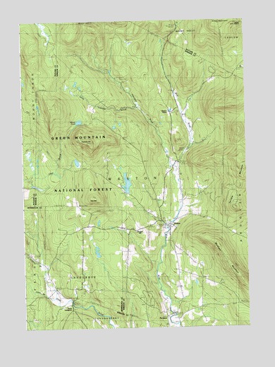
Weston, VT USGS Topographic Map
Click on map above to begin viewing in our Map Viewer.

This topographic map contains these locations and features:
Feature Name Type Latitude Longitude GNIS ID View Map
Beaver MeadowsSwampN43.3720°W72.8626°1460591View Map
Farrar ParkParkN43.2917°W72.7932°1922348View Map
Farrar-Mansur MuseumBuildingN43.2926°W72.7926°1922347View Map
Forefathers CemeteryCemeteryN43.2933°W72.7966°1922361View Map
Greendale BrookStreamN43.3159°W72.7909°1460937View Map
Greendale Camp and Picnic GroundsLocaleN43.3509°W72.8218°1461698View Map
Griffith BrookStreamN43.2762°W72.8648°1460939View Map
Holt MountainSummitN43.3029°W72.8359°1460997View Map
Island CemeteryCemeteryN43.2519°W72.7876°1922425View Map
Jenny Coolidge BrookStreamN43.3409°W72.8095°1461020View Map
Jones BrookStreamN43.2626°W72.8579°1461032View Map
Landgrove SchoolSchoolN43.2667°W72.8570°1461058View Map
Maple Grove CemeteryCemeteryN43.2943°W72.7872°1922454View Map
Markham MountainSummitN43.2740°W72.7584°1461130View Map
Morgan HillSummitN43.2901°W72.8123°1461171View Map
Moses PondLakeN43.3342°W72.8429°1461173View Map
New CemeteryCemeteryN43.2653°W72.8570°1920341View Map
North LandgrovePopulated PlaceN43.2598°W72.8487°1461230View Map
Old CemeteryCemeteryN43.2694°W72.8601°1920363View Map
Old Parish ChurchChurchN43.2901°W72.7934°1922508View Map
Peabody HillSummitN43.3251°W72.8373°1461260View Map
Peabody PondLakeN43.3173°W72.8443°1461701View Map
The IslandPopulated PlaceN43.2545°W72.7948°1461532View Map
Town of LandgroveCivilN43.2639°W72.8466°1462131View Map
Town of WestonCivilN43.3149°W72.8059°1462255View Map
Villiage Inn Winter Sports AreaLocaleN43.2598°W72.8587°1461702View Map
Wantastiquet LakeReservoirN43.3088°W72.8167°1766426View Map
Wantastiquet Lake DamDamN43.3051°W72.8145°1766425View Map
Wantastiquet Trout ClubLocaleN43.3079°W72.8193°1461808View Map
WestonPopulated PlaceN43.2912°W72.7932°1461600View Map
Weston Bowl MillLocaleN43.2992°W72.7870°1922710View Map
Weston Community ChurchChurchN43.2915°W72.7934°1922711View Map
Weston PlayhouseBuildingN43.2926°W72.7932°1922713View Map
Weston Post OfficePost OfficeN43.2911°W72.7931°1922714View Map
Weston PrioryChurchN43.3376°W72.7926°1461601View Map
Weston Village Historic DistrictParkN43.2912°W72.7934°1922715View Map
Weston Volunteer Fire DepartmentBuildingN43.2949°W72.7892°1922712View Map
Wilder Memorial LibraryBuildingN43.2915°W72.7948°1922732View Map
Zion ChapelChurchN43.3173°W72.7873°1461643View Map

Note: Coordinates in the location and feature list above are referenced to NAD83 datum.


Copyright (C) 2008-2024 Ryan Niemi / Sunset Dynamics ... All Rights Reserved