TopoQuest Logo
Do you find TopoQuest useful?
Help keep TopoQuest running and adding new maps/features by donating!
Bitcoin:  19c7KJd3qBynnjoSw5npx9KScwjBe4ifkT
Litecoin:  LXs6TkuXGGXo1vDsWCkWVdjQX94eUKd6ui
Home View Maps Find Maps Find Places Resources & Links


Long Lake, Texas Topographic Map

USGS Map Title: Long Lake, TX
USGS Map MRC: 31095F7
DRG (GeoTIFF) Download: o31095f7.tif


Neighboring USGS Topographic Map Quads:


  Yard, TX  
31095G8
 

  Tennessee Colony, TX  
31095G7
 

  Northwest Palestine, TX  
31095G6
 

  Butler, TX  
31095F8
 

  Long Lake, TX  
31095F7
 

  Southwest Palestine, TX  
31095F6
 

  Keechi, TX  
31095E8
 

  Oakwood, TX  
31095E7
 

  Indian Lake, TX  
31095E6


Map MRC Location:

N32°
W96°
N32°
W95°
H8 H7 H6 H5 H4 H3 H2 H1
G8 G7 G6 G5 G4 G3 G2 G1
F8 F7 F6 F5 F4 F3 F2 F1
E8 E7 E6 E5 E4 E3 E2 E1
D8 D7 D6 D5 D4 D3 D2 D1
C8 C7 C6 C5 C4 C3 C2 C1
B8 B7 B6 B5 B4 B3 B2 B1
A8 A7 A6 A5 A4 A3 A2 A1
N31°
W96°
N31°
W95°

Long Lake, TX USGS 1:24K Topographic Map Preview:
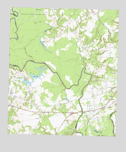
Long Lake, TX USGS Topographic Map
Click on map above to begin viewing in our Map Viewer.

This topographic map contains these locations and features:
Feature Name Type Latitude Longitude GNIS ID View Map
Big LakeReservoirN31.7122°W95.8342°1352091View Map
Big Lake Bottom Wildlife Management AreaParkN31.7082°W95.8569°2028789View Map
Blue LakeReservoirN31.6822°W95.8397°1352472View Map
Blue Lake DamDamN31.6918°W95.8352°1855593View Map
Brushy LakeLakeN31.6262°W95.7666°1353080View Map
Caney CreekStreamN31.6288°W95.7958°1372926View Map
Cedar LakeLakeN31.7288°W95.8321°1354126View Map
Cedar Lake SloughStreamN31.6966°W95.8463°1889590View Map
Gaston BranchStreamN31.6777°W95.8650°1357915View Map
Green Bay High SchoolSchoolN31.6541°W95.7588°1358369View Map
Keechie CreekStreamN31.6927°W95.7875°1360506View Map
Lake CreekStreamN31.7235°W95.8347°1374441View Map
Lake PortLakeN31.6655°W95.8719°1365597View Map
Little Brushy LakeLakeN31.6252°W95.7693°1374560View Map
Little LakeLakeN31.6591°W95.8047°1361399View Map
Long LakeLakeN31.6300°W95.7733°1361749View Map
Long LakePopulated PlaceN31.6496°W95.7811°1361751View Map
Long Lake Oil FieldOilfieldN31.6746°W95.7663°1361753View Map
Mount Pilgrim ChurchChurchN31.6643°W95.7558°1363302View Map
Mud LakeLakeN31.6455°W95.7840°1363410View Map
Saline BranchStreamN31.6777°W95.8647°1367364View Map
Smith LakeLakeN31.6613°W95.8078°1368491View Map
Texas Department of Criminal Justice Louis C Powledge UnitBuildingN31.7337°W95.8039°2738568View Map
Town CreekStreamN31.7013°W95.7908°1370054View Map

Note: Coordinates in the location and feature list above are referenced to NAD83 datum.


Copyright (C) 2008-2025 Ryan Niemi / Sunset Dynamics ... All Rights Reserved