TopoQuest Logo
Do you find TopoQuest useful?
Help keep TopoQuest running and adding new maps/features by donating!
Bitcoin:  19c7KJd3qBynnjoSw5npx9KScwjBe4ifkT
Litecoin:  LXs6TkuXGGXo1vDsWCkWVdjQX94eUKd6ui
Home View Maps Find Maps Find Places Resources & Links


Keechi, Texas Topographic Map

USGS Map Title: Keechi, TX
USGS Map MRC: 31095E8
DRG (GeoTIFF) Download: o31095e8.tif


Neighboring USGS Topographic Map Quads:


  Turlington, TX  
31096F1
 

  Butler, TX  
31095F8
 

  Long Lake, TX  
31095F7
 

  Lanely, TX  
31096E1
 

  Keechi, TX  
31095E8
 

  Oakwood, TX  
31095E7
 

  Buffalo, TX  
31096D1
 

  Flo, TX  
31095D8
 

  Lake Leon, TX  
31095D7


Map MRC Location:

N32°
W96°
N32°
W95°
H8 H7 H6 H5 H4 H3 H2 H1
G8 G7 G6 G5 G4 G3 G2 G1
F8 F7 F6 F5 F4 F3 F2 F1
E8 E7 E6 E5 E4 E3 E2 E1
D8 D7 D6 D5 D4 D3 D2 D1
C8 C7 C6 C5 C4 C3 C2 C1
B8 B7 B6 B5 B4 B3 B2 B1
A8 A7 A6 A5 A4 A3 A2 A1
N31°
W96°
N31°
W95°

Keechi, TX USGS 1:24K Topographic Map Preview:
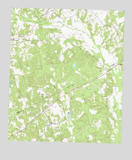
Keechi, TX USGS Topographic Map
Click on map above to begin viewing in our Map Viewer.

This topographic map contains these locations and features:
Feature Name Type Latitude Longitude GNIS ID View Map
Bess LakeReservoirN31.5174°W95.9005°1863856View Map
Bess Lake DamDamN31.5185°W95.8969°1863855View Map
Brook Spring BranchStreamN31.6102°W95.9419°1372731View Map
Brooke CemeteryCemeteryN31.6055°W95.9975°1372732View Map
Brown ChapelChurchN31.5955°W95.9977°1372740View Map
Connolly LakeReservoirN31.5531°W95.9981°1373183View Map
Connolly Lake DamDamN31.5518°W95.9319°1855564View Map
Holly BranchStreamN31.6127°W95.9683°1374108View Map
Jelly SloughStreamN31.6071°W95.9283°1374278View Map
KeechiPopulated PlaceN31.5168°W95.9533°1380866View Map
Keechi CemeteryCemeteryN31.5199°W95.9580°1374347View Map
Keechi LakeReservoirN31.5273°W95.9338°1374349View Map
Lipsey Lake Dam Number 2DamN31.5785°W95.8786°1864202View Map
Lipsey Lake Number 2ReservoirN31.5795°W95.8757°1864203View Map
Little Lake DamDamN31.5368°W95.8769°1864234View Map
Mount Zion ChurchChurchN31.5152°W95.9541°1375038View Map
Oakwood Dome Oil FieldOilfieldN31.5438°W95.9605°1375254View Map
Plum CreekPopulated PlaceN31.5982°W95.9855°1380901View Map
Plum Creek CemeteryCemeteryN31.5943°W95.9980°1375506View Map
Rocky Mount ChurchChurchN31.6099°W95.8972°1375810View Map
S C Pickins DamDamN31.5868°W95.9536°1855560View Map
S C Pickins LakeReservoirN31.5835°W95.9540°1855561View Map
T B Pickens DamDamN31.5785°W95.9536°1855562View Map
T B Pickens LakeReservoirN31.5768°W95.9529°1855563View Map
Tan Yard BranchStreamN31.6127°W95.9864°1376377View Map
Trahin SchoolSchoolN31.5924°W95.9914°1376489View Map
Twin BranchStreamN31.5343°W95.8836°1376541View Map
Willis CemeteryCemeteryN31.6229°W95.9847°1376810View Map

Note: Coordinates in the location and feature list above are referenced to NAD83 datum.


Copyright (C) 2008-2025 Ryan Niemi / Sunset Dynamics ... All Rights Reserved