TopoQuest Logo
Do you find TopoQuest useful?
Help keep TopoQuest running and adding new maps/features by donating!
Bitcoin:  19c7KJd3qBynnjoSw5npx9KScwjBe4ifkT
Litecoin:  LXs6TkuXGGXo1vDsWCkWVdjQX94eUKd6ui
Home View Maps Find Maps Find Places Resources & Links


Long Lake, Mississippi Topographic Map

USGS Map Title: Long Lake, MS
USGS Map MRC: 32090D8
DRG (GeoTIFF) Download: o32090d8.tif


Neighboring USGS Topographic Map Quads:


  Eagle Bend, MS  
32091E1
 

  Cane Bayou, MS  
32090E8
 

  Floweree, MS  
32090E7
 

  Ashly, LA  
32091D1
 

  Long Lake, MS  
32090D8
 

  Redwood, MS  
32090D7
 

  Mound, LA  
32091C1
 

  Vicksburg West, MS  
32090C8
 

  Vicksburg East, MS  
32090C7


Map MRC Location:

N33°
W91°
N33°
W90°
H8 H7 H6 H5 H4 H3 H2 H1
G8 G7 G6 G5 G4 G3 G2 G1
F8 F7 F6 F5 F4 F3 F2 F1
E8 E7 E6 E5 E4 E3 E2 E1
D8 D7 D6 D5 D4 D3 D2 D1
C8 C7 C6 C5 C4 C3 C2 C1
B8 B7 B6 B5 B4 B3 B2 B1
A8 A7 A6 A5 A4 A3 A2 A1
N32°
W91°
N32°
W90°

Long Lake, MS USGS 1:24K Topographic Map Preview:
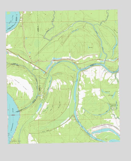
Long Lake, MS USGS Topographic Map
Click on map above to begin viewing in our Map Viewer.

This topographic map contains these locations and features:
Feature Name Type Latitude Longitude GNIS ID View Map
Alligator LakeLakeN32.4226°W90.8911°666227View Map
Alligator LakeSwampN32.4781°W90.8760°666233View Map
Boat SloughGutN32.4349°W90.8782°667351View Map
Boats Slough Landing (historical)LocaleN32.4404°W90.8795°707639View Map
Brecount LakeLakeN32.4456°W90.9701°667537View Map
Browns Point LandingLocaleN32.4040°W90.9854°707642View Map
Crooks Point Landing (historical)LocaleN32.4429°W90.9168°707648View Map
Cypress BayouStreamN32.4857°W90.9023°693025View Map
Dalneys LandingLocaleN32.4279°W90.9587°709488View Map
Duck LakeLakeN32.4808°W90.9231°669472View Map
Eagle Lake FerryCrossingN32.4432°W90.9162°707650View Map
False River (historical)StreamN32.4432°W90.9184°707651View Map
Fish LakeSwampN32.4082°W90.9498°669984View Map
Goose LakeLakeN32.4656°W90.8791°670517View Map
Halpino Landing (historical)LocaleN32.4513°W90.9940°686332View Map
Horseshoe LakeLakeN32.4524°W90.8811°687599View Map
Indian Camp LakeLakeN32.4195°W90.8812°671675View Map
Kings FerryCrossingN32.4004°W90.9243°672175View Map
Landing Number Eightyfive (historical)LocaleN32.4132°W90.9312°691040View Map
Little Cuba LandingLocaleN32.4290°W90.9207°707662View Map
Little Flat LakeLakeN32.4100°W90.8785°672609View Map
Locust Grove Landing (historical)LocaleN32.4313°W90.9512°707665View Map
Long LakeLakeN32.4016°W90.8936°672832View Map
Long LakePopulated PlaceN32.4088°W90.8834°672841View Map
McKees LandingLocaleN32.4390°W90.9557°709494View Map
Moon LakeLakeN32.4650°W90.9082°673761View Map
Old ChannelChannelN32.4493°W90.9459°675168View Map
Paw Paw ChuteGutN32.4149°W90.9707°675511View Map
Paw Paw ChuteStreamN32.4063°W90.9868°538026View Map
Paw Paw IslandIslandN32.4351°W90.9932°555609View Map
Paw Paw LandingLocaleN32.4296°W90.9657°707671View Map
Pilgrims Rest ChurchChurchN32.4426°W90.9145°675773View Map
Pleasant Valley ChurchChurchN32.4410°W90.8765°676140View Map
Steele BayouStreamN32.4488°W90.8912°678260View Map
Steele Bayou LandingLocaleN32.4488°W90.8926°709497View Map
Sweets Ferry (historical)CrossingN32.4488°W90.8959°690949View Map
Taylor LakeLakeN32.4296°W90.9526°678600View Map
Taylor PlantationLocaleN32.4293°W90.9501°686386View Map
Vicksburg Harbor ProjectLocaleN32.3899°W90.8957°711328View Map
Wallace Lake (historical)LakeN32.4921°W90.9284°691041View Map
White House Landing (historical)LocaleN32.4096°W90.9609°707691View Map
Whteman LakeSwampN32.4126°W90.9409°679660View Map
Williams PlantationLocaleN32.4113°W90.9584°686406View Map
Willow BayouGutN32.4757°W90.9640°691042View Map
Willow BayouSwampN32.4065°W90.9568°679735View Map
Wilton BayouSwampN32.3868°W90.9576°679775View Map

Note: Coordinates in the location and feature list above are referenced to NAD83 datum.


Copyright (C) 2008-2025 Ryan Niemi / Sunset Dynamics ... All Rights Reserved