TopoQuest Logo
Do you find TopoQuest useful?
Help keep TopoQuest running and adding new maps/features by donating!
Bitcoin:  19c7KJd3qBynnjoSw5npx9KScwjBe4ifkT
Litecoin:  LXs6TkuXGGXo1vDsWCkWVdjQX94eUKd6ui
Home View Maps Find Maps Find Places Resources & Links


Loup Loup Summit, Washington Topographic Map

USGS Map Title: Loup Loup Summit, WA
USGS Map MRC: 48119D8
DRG (GeoTIFF) Download: o48119d8.tif


Neighboring USGS Topographic Map Quads:


  Pearrygin Peak, WA  
48120E1
 

  Old Baldy, WA  
48119E8
 

  Conconully West, WA  
48119E7
 

  Blue Buck Mountain, WA  
48120D1
 

  Loup Loup Summit, WA  
48119D8
 

  Buck Mountain, WA  
48119D7
 

  Twisp East, WA  
48120C1
 

  Thrapp Mountain, WA  
48119C8
 

  Chiliwist Valley, WA  
48119C7


Map MRC Location:

N49°
W120°
N49°
W119°
H8 H7 H6 H5 H4 H3 H2 H1
G8 G7 G6 G5 G4 G3 G2 G1
F8 F7 F6 F5 F4 F3 F2 F1
E8 E7 E6 E5 E4 E3 E2 E1
D8 D7 D6 D5 D4 D3 D2 D1
C8 C7 C6 C5 C4 C3 C2 C1
B8 B7 B6 B5 B4 B3 B2 B1
A8 A7 A6 A5 A4 A3 A2 A1
N48°
W120°
N48°
W119°

Loup Loup Summit, WA USGS 1:24K Topographic Map Preview:
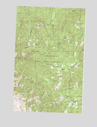
Loup Loup Summit, WA USGS Topographic Map
Click on map above to begin viewing in our Map Viewer.

This topographic map contains these locations and features:
Feature Name Type Latitude Longitude GNIS ID View Map
Bear MountainSummitN48.4129°W119.9231°1516281View Map
Beaver RidgeRidgeN48.4840°W119.9845°1516347View Map
Bobcat MountainSummitN48.4568°W119.8976°1516740View Map
Granite MountainSummitN48.4963°W119.8967°1520234View Map
Hidden CampLocaleN48.3993°W119.9006°1520745View Map
J R Picnic AreaLocaleN48.3893°W119.8959°1521283View Map
Leighty CampLocaleN48.4254°W119.8901°1521999View Map
Lightning CreekStreamN48.4510°W119.9984°1522071View Map
Lightning Creek RidgeRidgeN48.4465°W119.9859°1522073View Map
Little Buck MountainSummitN48.3876°W119.9267°1522174View Map
Loup Loup CampgroundLocaleN48.3957°W119.9026°1528714View Map
Loup Loup Recreation AreaLocaleN48.3910°W119.8881°1522521View Map
Loup Loup Ski AreaLocaleN48.3910°W119.9178°1529679View Map
Loup Loup SummitSummitN48.3885°W119.8873°1522522View Map
Methow Winter Range and Wildlife RefugeParkN48.3844°W119.9795°1529938View Map
Middle ForkStreamN48.4385°W119.9823°1523060View Map
Middle RidgeRidgeN48.4460°W119.9262°1523103View Map
South Fork MeadowsFlatN48.4263°W119.9092°1526217View Map
South RidgeRidgeN48.4138°W119.9701°1526311View Map
South SummitLocaleN48.3838°W119.8998°1529678View Map

Note: Coordinates in the location and feature list above are referenced to NAD83 datum.


Copyright (C) 2008-2025 Ryan Niemi / Sunset Dynamics ... All Rights Reserved