TopoQuest Logo
Do you find TopoQuest useful?
Help keep TopoQuest running and adding new maps/features by donating!
Bitcoin:  19c7KJd3qBynnjoSw5npx9KScwjBe4ifkT
Litecoin:  LXs6TkuXGGXo1vDsWCkWVdjQX94eUKd6ui
Home View Maps Find Maps Find Places Resources & Links


Loveland, Colorado Topographic Map

USGS Map Title: Loveland, CO
USGS Map MRC: 40105D1
DRG (GeoTIFF) Download: o40105d1.tif


Neighboring USGS Topographic Map Quads:


  Horsetooth Reservoir, CO  
40105E2
 

  Fort Collins, CO  
40105E1
 

  Timnath, CO  
40104E8
 

  Masonville, CO  
40105D2
 

  Loveland, CO  
40105D1
 

  Windsor, CO  
40104D8
 

  Carter Lake Reservoir, CO  
40105C2
 

  Berthoud, CO  
40105C1
 

  Johnstown, CO  
40104C8


Map MRC Location:

N41°
W106°
N41°
W105°
H8 H7 H6 H5 H4 H3 H2 H1
G8 G7 G6 G5 G4 G3 G2 G1
F8 F7 F6 F5 F4 F3 F2 F1
E8 E7 E6 E5 E4 E3 E2 E1
D8 D7 D6 D5 D4 D3 D2 D1
C8 C7 C6 C5 C4 C3 C2 C1
B8 B7 B6 B5 B4 B3 B2 B1
A8 A7 A6 A5 A4 A3 A2 A1
N40°
W106°
N40°
W105°

Loveland, CO USGS 1:24K Topographic Map Preview:
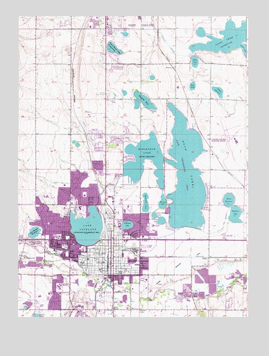
Loveland, CO USGS Topographic Map
Click on map above to begin viewing in our Map Viewer.

This topographic map contains these locations and features:
Feature Name Type Latitude Longitude GNIS ID View Map
A and A DairyLocaleN40.4544°W105.0519°2707038View Map
Alford LakesLakeN40.4472°W105.0939°177734View Map
All Saints Episcopal Church ColumbariumCemeteryN40.4266°W105.0964°2036929View Map
Big Barnes DitchCanalN40.4028°W105.1141°202492View Map
Big Thompson PitMineN40.4000°W105.0744°1683574View Map
Bill Reed Middle SchoolSchoolN40.3951°W105.0801°1923134View Map
Boyd LakeReservoirN40.4336°W105.0335°177738View Map
Boyd Lake DamDamN40.4405°W105.0455°198466View Map
Boyd Lake QuarryMineN40.4000°W105.0744°1683575View Map
Boyd Lake State ParkParkN40.4333°W105.0417°2097203View Map
Browns CornerPopulated PlaceN40.4075°W105.0589°177715View Map
Cattail PondLakeN40.3754°W105.1150°202495View Map
Cemetery LakeLakeN40.4133°W105.0657°177712View Map
Cemetery Lake DamDamN40.4117°W105.0672°200298View Map
Centennial Elementary SchoolSchoolN40.4300°W105.0999°1923140View Map
Cherry HillSummitN40.3786°W105.0933°177723View Map
City of LovelandCivilN40.4169°W105.0620°2410886View Map
Conrad Ball Middle SchoolSchoolN40.4193°W105.0670°1923135View Map
Coulson Excavating PitMineN40.4000°W105.0744°1683577View Map
Coulson PitMineN40.4000°W105.0744°1683576View Map
Donath LakeReservoirN40.4649°W105.0563°201671View Map
Dry CreekStreamN40.4339°W105.0678°177724View Map
Duck LakeReservoirN40.4810°W105.0288°177731View Map
Duck Lake DamDamN40.4828°W105.0308°201712View Map
Equalizer LakeReservoirN40.4177°W105.0067°177736View Map
Farmers DitchCanalN40.4083°W105.0061°202496View Map
Fort Collins-Loveland Municipal AirportAirportN40.4492°W105.0082°177743View Map
Fossil Creek ReservoirReservoirN40.4903°W105.0081°202498View Map
Garfield Elementary SchoolSchoolN40.3994°W105.0872°177709View Map
Haag PitMineN40.4000°W105.0744°1683578View Map
Haags Sand and Gravel PitMineN40.3986°W105.0853°1683583View Map
Heinricy LakeReservoirN40.4229°W105.0464°177740View Map
Hollowell CornerLocaleN40.3783°W105.0591°177721View Map
Horseshoe LakeReservoirN40.4395°W105.0563°177739View Map
Houts DamDamN40.4264°W105.0094°201672View Map
Houts ReservoirReservoirN40.4237°W105.0102°177737View Map
Kauffman PitMineN40.4000°W105.0744°1683579View Map
Kings CornerPopulated PlaceN40.3783°W105.0733°177722View Map
KLOV-AM (Loveland)TowerN40.3919°W105.0980°204039View Map
Lake LovelandReservoirN40.4122°W105.0874°177713View Map
Lakeside CemeteryCemeteryN40.4119°W105.0716°177710View Map
Lakeside ParkParkN40.4064°W105.0803°177711View Map
Lincoln SchoolSchoolN40.4078°W105.0736°177708View Map
Little Barnes DitchCanalN40.4083°W105.0639°177742View Map
Loch Lon ParkParkN40.3833°W105.1086°1923141View Map
Louden DitchCanalN40.4305°W105.1016°202491View Map
LovelandPopulated PlaceN40.3978°W105.0750°177720View Map
Loveland Burial ParkCemeteryN40.4128°W105.0752°2036966View Map
Loveland Fire and Rescue Station 1BuildingN40.3962°W105.0716°2666881View Map
Loveland Fire and Rescue Station 2BuildingN40.4194°W105.0964°2667079View Map
Loveland Fire and Rescue Station 3BuildingN40.3833°W105.1156°2667078View Map
Loveland Fire and Rescue Station 4BuildingN40.4498°W105.0054°2667353View Map
Loveland Fire and Rescue Station 5BuildingN40.4389°W105.0756°2667077View Map
Loveland Fire and Rescue Station 6BuildingN40.4102°W105.0164°2667029View Map
Loveland Gravel PitMineN40.3980°W105.1211°1683580View Map
Loveland High SchoolSchoolN40.4206°W105.0916°1923138View Map
Loveland Memeorial HospitalHospitalN40.3978°W105.0897°1923144View Map
Loveland Police DepartmentBuildingN40.4008°W105.0665°2680089View Map
Loveland Post OfficePost OfficeN40.4211°W105.0706°2750929View Map
Loveland Sugar Refinery QuarryMineN40.4050°W105.0630°1683573View Map
Lower Hoffman LakeLakeN40.4153°W105.0472°177707View Map
Lucile Erwin Middle SchoolSchoolN40.4297°W105.0997°1923136View Map
McKee Medical CenterHospitalN40.4132°W105.0516°1853933View Map
McKee Medical Center HeliportAirportN40.4119°W105.0514°204502View Map
Memorial Hospital (historical)HospitalN40.3972°W105.0903°177719View Map
Modena CemeteryCemeteryN40.3997°W105.1231°2036933View Map
Mount Hope SchoolSchoolN40.4605°W105.0528°177726View Map
Mud LakeLakeN40.4710°W105.0300°177732View Map
Namaqua ParkParkN40.4000°W105.1186°1923142View Map
Nelson ReservoirReservoirN40.4688°W105.0160°177730View Map
Osborn ParkParkN40.3908°W105.0572°1923143View Map
Poudre Fire Authority Fire Station 14BuildingN40.4968°W105.0387°2667199View Map
RedmondPopulated PlaceN40.4789°W105.0408°177727View Map
Resthaven Memorial GardensCemeteryN40.4672°W105.0761°177725View Map
Rist Benson ReservoirReservoirN40.4103°W105.1162°177714View Map
Robert Benson LakeReservoirN40.4865°W105.0732°177729View Map
Rollers LakeLakeN40.4316°W105.0941°177735View Map
Ryan GulchValleyN40.3855°W105.0940°177744View Map
Say Hawker PitMineN40.3986°W105.1066°1683584View Map
Sierra Vista Nursing HomeHospitalN40.4003°W105.0928°177718View Map
Swart PitMineN40.4000°W105.0744°1683581View Map
Thompson Valley Emergency Medical ServicesBuildingN40.3957°W105.1135°2716995View Map
Thompson Valley High SchoolSchoolN40.3877°W105.1025°1923139View Map
Trilby CornerPopulated PlaceN40.4947°W105.0775°177728View Map
Truscott Elementary SchoolSchoolN40.3980°W105.0789°177716View Map
U.S. Gypsum QuarryMineN40.4000°W105.0744°1683582View Map
Upper Hoffman LakeLakeN40.4159°W105.0483°177706View Map
Valentine Post OfficePost OfficeN40.3978°W105.0748°2750930View Map
Walt Clark Middle SchoolSchoolN40.3838°W105.1134°1923137View Map
Washington SchoolSchoolN40.3939°W105.0700°177717View Map
Westerdoll LakeLakeN40.4216°W105.0557°177741View Map

Note: Coordinates in the location and feature list above are referenced to NAD83 datum.


Copyright (C) 2008-2025 Ryan Niemi / Sunset Dynamics ... All Rights Reserved