TopoQuest Logo
Do you find TopoQuest useful?
Help keep TopoQuest running and adding new maps/features by donating!
Bitcoin:  19c7KJd3qBynnjoSw5npx9KScwjBe4ifkT
Litecoin:  LXs6TkuXGGXo1vDsWCkWVdjQX94eUKd6ui
Home View Maps Find Maps Find Places Resources & Links


Lower Lake Mary, Arizona Topographic Map

USGS Map Title: Lower Lake Mary, AZ
USGS Map MRC: 35111A5
DRG (GeoTIFF) Download: o35111a5.tif


Neighboring USGS Topographic Map Quads:


  Flagstaff West, AZ  
35111B6
 

  Flagstaff East, AZ  
35111B5
 

  Winona, AZ  
35111B4
 

  Mountainaire, AZ  
35111A6
 

  Lower Lake Mary, AZ  
35111A5
 

  Ashurst Lake, AZ  
35111A4
 

  Munds Park, AZ  
34111H6
 

  Mormon Mountain, AZ  
34111H5
 

  Mormon Lake, AZ  
34111H4


Map MRC Location:

N36°
W112°
N36°
W111°
H8 H7 H6 H5 H4 H3 H2 H1
G8 G7 G6 G5 G4 G3 G2 G1
F8 F7 F6 F5 F4 F3 F2 F1
E8 E7 E6 E5 E4 E3 E2 E1
D8 D7 D6 D5 D4 D3 D2 D1
C8 C7 C6 C5 C4 C3 C2 C1
B8 B7 B6 B5 B4 B3 B2 B1
A8 A7 A6 A5 A4 A3 A2 A1
N35°
W112°
N35°
W111°

Lower Lake Mary, AZ USGS 1:24K Topographic Map Preview:
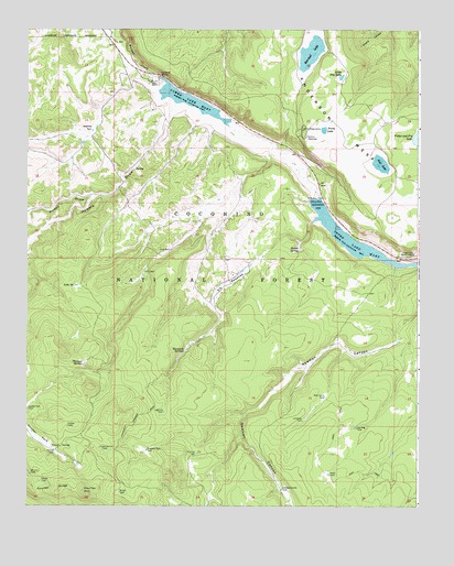
Lower Lake Mary, AZ USGS Topographic Map
Click on map above to begin viewing in our Map Viewer.

This topographic map contains these locations and features:
Feature Name Type Latitude Longitude GNIS ID View Map
Babbit SpringSpringN35.0670°W111.5385°25862View Map
Bonita TankReservoirN35.0036°W111.5956°26595View Map
Caņada Granda TankReservoirN35.0045°W111.5437°27241View Map
Canyon Vista CampgroundLocaleN35.1239°W111.5984°2670008View Map
Charco TankReservoirN35.0067°W111.6208°27507View Map
Clark WellWellN35.0672°W111.5796°27686View Map
Corner TankReservoirN35.0145°W111.6164°27952View Map
Coulter CabinLocaleN35.0209°W111.6121°28068View Map
Coulter HillSummitN35.0031°W111.6063°28069View Map
Coulter ParkFlatN35.0181°W111.6213°28071View Map
Double TankReservoirN35.1168°W111.6172°37757View Map
Elk Park MeadowsFlatN35.0584°W111.5615°28855View Map
Fisher and Fry LakeLakeN35.0970°W111.5007°29024View Map
Forest Service TankReservoirN35.0149°W111.6011°29100View Map
Hey Dog TankReservoirN35.0208°W111.5200°29915View Map
Highlands Fire District Station 24 Lake MaryBuildingN35.1155°W111.5942°2672660View Map
Hold Up TankReservoirN35.0138°W111.5710°30047View Map
Howard DrawValleyN35.1056°W111.5779°30250View Map
Howard TankReservoirN35.0631°W111.6239°2090364View Map
Hoxworth SpringsSpringN35.0403°W111.5750°30259View Map
Hoxworth TankReservoirN35.0428°W111.5714°2090361View Map
JAO WellWellN35.0617°W111.5879°30453View Map
Joeys TankReservoirN35.0085°W111.5288°30565View Map
Johnneys TankReservoirN35.0225°W111.5373°30571View Map
KZJC-TV (Flagstaff)TowerN35.0734°W111.5690°45272View Map
Lagunita TankReservoirN35.0247°W111.5818°30842View Map
Lake Mary Boating SiteLocaleN35.0734°W111.5249°37887View Map
Lake Mary MeadowsFlatN35.0900°W111.5854°37888View Map
Lake Number OneLakeN35.0578°W111.6094°32328View Map
Lake View Forest CampLocaleN35.0661°W111.5018°30854View Map
Little Dry LakeLakeN35.1126°W111.5252°31061View Map
Little Dry Lake TankReservoirN35.1133°W111.5233°2090353View Map
Lost TankReservoirN35.0758°W111.5081°2090359View Map
Lower Lake MaryReservoirN35.1051°W111.5723°31364View Map
Lower Lake Mary DamDamN35.1125°W111.5832°37917View Map
Lower Lake Mary Picnic AreaLocaleN35.1111°W111.5837°2669529View Map
Lower TankReservoirN35.1194°W111.5300°2090352View Map
Marshall LakeLakeN35.1198°W111.5350°31531View Map
Marshall Mesa TankReservoirN35.1197°W111.5629°37926View Map
Mount Lion TankReservoirN35.0085°W111.6239°32075View Map
Mustang Park TankReservoirN35.0146°W111.5870°32217View Map
Nameless TankReservoirN35.0753°W111.5736°2090356View Map
Narrows Boat LaunchLocaleN35.0639°W111.5012°2669948View Map
Natural TankReservoirN35.0356°W111.5381°2090362View Map
Newman TankReservoirN35.0432°W111.5067°37968View Map
Perkins TelescopeBuildingN35.0970°W111.5368°32801View Map
Peterson SeepageReservoirN35.0156°W111.6174°32830View Map
Pit Number Two TankReservoirN35.0584°W111.5257°37999View Map
Pit One TankReservoirN35.0603°W111.5333°2090360View Map
Priest DrawValleyN35.0814°W111.6038°33195View Map
Prime LakeLakeN35.0990°W111.5309°33201View Map
Roadbed TankReservoirN35.0982°W111.6046°33661View Map
Rocky TankReservoirN35.0544°W111.5172°2090363View Map
Sinkhole TankReservoirN35.0139°W111.5083°38075View Map
Statler TankReservoirN35.0894°W111.6100°2090355View Map
Stump TankReservoirN35.0722°W111.5647°2090357View Map
Thomas SpringSpringN35.0373°W111.6076°35274View Map
United States Geological Survey ObservatoryLocaleN35.0995°W111.5368°35663View Map
Upper Lake Mary Boat Launch Number 2LocaleN35.0712°W111.5220°2669871View Map
Upper Lake Mary DamDamN35.0809°W111.5318°38137View Map
Vail LakeLakeN35.0899°W111.5129°35747View Map
Vail Lake TankReservoirN35.0875°W111.5097°2090358View Map
Westec TankReservoirN35.0964°W111.6178°2090354View Map
Wild Horse TankReservoirN35.0287°W111.5303°36172View Map

Note: Coordinates in the location and feature list above are referenced to NAD83 datum.


Copyright (C) 2008-2024 Ryan Niemi / Sunset Dynamics ... All Rights Reserved