TopoQuest Logo
Do you find TopoQuest useful?
Help keep TopoQuest running and adding new maps/features by donating!
Bitcoin:  19c7KJd3qBynnjoSw5npx9KScwjBe4ifkT
Litecoin:  LXs6TkuXGGXo1vDsWCkWVdjQX94eUKd6ui
Home View Maps Find Maps Find Places Resources & Links


Mountainaire, Arizona Topographic Map

USGS Map Title: Mountainaire, AZ
USGS Map MRC: 35111A6
DRG (GeoTIFF) Download: o35111a6.tif


Neighboring USGS Topographic Map Quads:


  Bellemont, AZ  
35111B7
 

  Flagstaff West, AZ  
35111B6
 

  Flagstaff East, AZ  
35111B5
 

  Dutton Hill, AZ  
35111A7
 

  Mountainaire, AZ  
35111A6
 

  Lower Lake Mary, AZ  
35111A5
 

  Wilson Mountain, AZ  
34111H7
 

  Munds Park, AZ  
34111H6
 

  Mormon Mountain, AZ  
34111H5


Map MRC Location:

N36°
W112°
N36°
W111°
H8 H7 H6 H5 H4 H3 H2 H1
G8 G7 G6 G5 G4 G3 G2 G1
F8 F7 F6 F5 F4 F3 F2 F1
E8 E7 E6 E5 E4 E3 E2 E1
D8 D7 D6 D5 D4 D3 D2 D1
C8 C7 C6 C5 C4 C3 C2 C1
B8 B7 B6 B5 B4 B3 B2 B1
A8 A7 A6 A5 A4 A3 A2 A1
N35°
W112°
N35°
W111°

Mountainaire, AZ USGS 1:24K Topographic Map Preview:
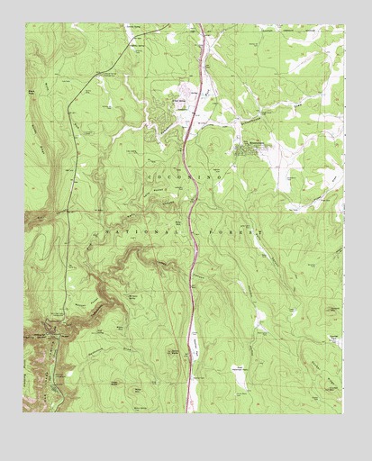
Mountainaire, AZ USGS Topographic Map
Click on map above to begin viewing in our Map Viewer.

This topographic map contains these locations and features:
Feature Name Type Latitude Longitude GNIS ID View Map
Black PassGapN35.1025°W111.7496°26434View Map
Butte TankReservoirN35.0111°W111.7096°2090051View Map
Chavez TankReservoirN35.0257°W111.6844°27533View Map
Claude Black TankReservoirN35.0063°W111.6673°27688View Map
Cookstove DrawValleyN35.0147°W111.7377°27875View Map
Coulter MountainSummitN35.0081°W111.6307°28070View Map
Coulter Park TankReservoirN35.0254°W111.6251°28072View Map
Coulter RidgeRidgeN35.0134°W111.6329°28073View Map
Coulter TankReservoirN35.0050°W111.6348°28074View Map
Crusher SinkReservoirN35.0897°W111.7266°28200View Map
Dewey Grade TankReservoirN35.0969°W111.6581°28448View Map
East Newman ParkFlatN35.0122°W111.6654°28778View Map
Eightynine A TankReservoirN35.0776°W111.7307°28829View Map
Forest Highlands Golf ClubLocaleN35.1075°W111.7041°2669905View Map
Freeway TankReservoirN35.0089°W111.6896°2090053View Map
Fry CanyonValleyN35.0614°W111.7202°29222View Map
Gates Cabin TankReservoirN35.0603°W111.6619°29277View Map
Griffiths SpringSpringN35.1172°W111.7092°29603View Map
Griffiths TankReservoirN35.1158°W111.7073°29604View Map
Half Pint TankReservoirN35.0233°W111.6278°29687View Map
Heckethorn TankReservoirN35.0755°W111.6478°29845View Map
Highlands Fire District Headquarters Station 21BuildingN35.0972°W111.6961°2672425View Map
Highlands Fire District Station 22 Bear Jaw Fire and Fuels ModuleBuildingN35.0858°W111.6553°2672658View Map
Highlands Fire District Station 23 MountainaireBuildingN35.0940°W111.6791°2672659View Map
Highlands Fire District Station 25 Forest HighlandsBuildingN35.1082°W111.7030°2672661View Map
Howard MountainSummitN35.0336°W111.6307°30253View Map
James CanyonValleyN35.0433°W111.7202°30500View Map
James TankReservoirN35.0422°W111.7054°2090057View Map
Kachina VillagePopulated PlaceN35.0970°W111.6927°1866987View Map
Kachina Village Census Designated PlaceCensusN35.0949°W111.6926°2408458View Map
Kelly CanyonValleyN35.0589°W111.7171°30726View Map
Kelly Canyon InterchangeCrossingN35.0520°W111.6827°37871View Map
Kelly PocketBasinN35.0714°W111.7007°30727View Map
Kelly SeepSpringN35.0609°W111.6889°30728View Map
Kelly TankReservoirN35.0510°W111.6553°37872View Map
Landon SpringSpringN35.1238°W111.7115°30869View Map
Limbergh SpringSpringN35.1082°W111.7211°37900View Map
Lindbergh Spring Roadside ParkParkN35.1086°W111.7207°31002View Map
Log Landing TankReservoirN35.0835°W111.7059°31185View Map
Lowlander TankReservoirN35.0721°W111.6880°31389View Map
Mexican PocketBasinN35.0345°W111.7252°31784View Map
Mortgage SpringSpringN35.0373°W111.7097°32064View Map
Mortgage TankRangeN35.0383°W111.7007°2090048View Map
MountainairePopulated PlaceN35.0853°W111.6660°32083View Map
Mountainaire Census Designated PlaceCensusN35.0920°W111.6493°2408886View Map
Newman ParkLakeN35.0202°W111.6837°32313View Map
Newman Park InterchangeCrossingN35.0186°W111.6849°37967View Map
Newman TankReservoirN35.0111°W111.6839°32318View Map
O'Neil SpringSpringN35.1005°W111.6873°32424View Map
Oak Creek VistaLocaleN35.0328°W111.7332°41180View Map
Oak Creek Vista CampgroundLocaleN35.0314°W111.7343°32438View Map
Oat TankReservoirN35.0192°W111.7093°2090056View Map
Pine Flat CampgroundLocaleN35.0117°W111.7377°32936View Map
Point TankReservoirN35.0486°W111.7085°2090058View Map
Priest TankReservoirN35.0687°W111.6348°33196View Map
Pumphouse WashStreamN35.0239°W111.7360°33226View Map
Quarry SinkReservoirN35.1030°W111.7267°33262View Map
Raymond ParkParkN35.0917°W111.7243°38029View Map
Ritter ButteSummitN35.0097°W111.7127°33642View Map
Ritter Butte TankReservoirN35.0128°W111.7167°2090054View Map
Ritter MountainSummitN35.0075°W111.7065°33643View Map
Ritter SpringSpringN35.0013°W111.7062°33644View Map
Ritter TankReservoirN35.0102°W111.6977°33645View Map
Saginaw SinkReservoirN35.0781°W111.6731°33943View Map
Schoolhouse DrawValleyN35.0961°W111.6840°34142View Map
Scott SpringSpringN35.0261°W111.7213°34165View Map
Scott TankReservoirN35.0222°W111.7154°2090055View Map
Section Sixteen TankReservoirN35.1183°W111.6593°34209View Map
Section Twentyfour TankReservoirN35.0982°W111.7161°34219View Map
Seruchos TankReservoirN35.0477°W111.6365°34266View Map
Smith ButteSummitN35.0197°W111.6924°34546View Map
Smith Butte TankReservoirN35.0193°W111.6877°2090049View Map
Sterling CanyonValleyN35.0245°W111.7365°34832View Map
Sterling SpringSpringN35.0250°W111.7402°34834View Map
Tinaja TankReservoirN35.0334°W111.6443°35342View Map
Tule TankReservoirN35.1063°W111.7324°35514View Map
Twin TanksReservoirN35.0657°W111.6425°35634View Map
Ward Camp TankReservoirN35.0263°W111.6554°35891View Map
Willson TankReservoirN35.0295°W111.7065°41169View Map
Wilson SeepSpringN35.0271°W111.7110°36293View Map
Wilson TankReservoirN35.0300°W111.7063°38188View Map
Woody WashStreamN35.0831°W111.7188°36394View Map

Note: Coordinates in the location and feature list above are referenced to NAD83 datum.


Copyright (C) 2008-2025 Ryan Niemi / Sunset Dynamics ... All Rights Reserved